Milstead, Alabama
Unincorporated community in Alabama, United States
32°26′33″N 85°53′51″W / 32.44250°N 85.89750°W / 32.44250; -85.89750Milstead, also known as Cowles or Cowles Station, is an unincorporated community in Macon County, Alabama, United States.
History
The community was named after the location where a gristmill once stood by the Tallapoosa River.[2] Milstead was located at the junction of the Tallassee and Montgomery Railway and the Western Railway of Alabama.[3]
Fort Decatur, a fort built during the Creek War, was located near Milstead. John Sevier died here while conducting a survey of Creek lands.[4]
A post office operated under the name Cowle's Station from 1867 to 1895, under the name Cowles from 1895 to 1896, and under the name Milstead from 1896 to 1964.[5]
Auburn University maintains the E.V. Smith Research Center in Milstead.[4]
Gallery
-
 Auburn University's E.V. Smith Research Center is located in Milstead.
 -
 The Tallapoosa River at Milstead
 -
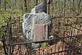 The site of Fort Decatur, an earthen fort established in March 1814 as part of the Creek War and the larger War of 1812, is located on the banks of the Tallapoosa River near modern-day Milstead. Today, the fort site is marked by a historical marker (pictured) that was placed by the Alabama Anthropological Society in 1931.


References
- ^ "Milstead". Geographic Names Information System. United States Geological Survey, United States Department of the Interior.
- ^ Foscue, Virginia (1989). Place Names in Alabama. Tuscaloosa: The University of Alabama Press. p. 94. ISBN 0-8173-0410-X.
- ^ The American and English railroad cases: a collection of all cases, affecting railroads of every kind, decided by the courts of appellate jurisdiction in the United States, England, and Canada [1894-1913]. E. Thompson Co. 1901. pp. 171.
- ^ a b Mike Bunn; Clay Williams (July 1, 2008). Battle for the Southern Frontier: The Creek War and the War of 1812. Arcadia Publishing Incorporated. p. 59. ISBN 978-1-62584-381-4.
- ^ "Macon County". Jim Forte Postal History. Retrieved April 3, 2020.
- v
- t
- e
Municipalities and communities of Macon County, Alabama, United States
County seat: Tuskegee

communities
‡This populated place also has portions in an adjacent county or counties
- Alabama portal
- United States portal
Unincorporated community in Alabama, United States
 | This Macon County, Alabama state location article is a stub. You can help Wikipedia by expanding it. |
- v
- t
- e


