Maroantsetra
Commune and town in Analanjirofo, Madagascar
Maroantsetra Louisbourg | |
|---|---|
Commune and town | |
| 15°26′0″S 49°45′0″E / 15.43333°S 49.75000°E / -15.43333; 49.75000 | |
| Country |  Madagascar Madagascar |
| Region | Analanjirofo |
| District | Maroantsetra |
| Government | |
| • Type | Urban municipality |
| • Mayor | Ahmad Ch. Soilihi |
| Elevation | 14 m (46 ft) |
| Population (2018)Census | |
| • Total | 42,529 |
| Demonym | Antimaroa |
| Time zone | UTC3 (EAT) |
| Postal code | 512 |
Maroantsetra [maronˈtseʈʂə̥], formerly Louisbourg, is a market town and domestic seaport in Analanjirofo Region, Madagascar, at the northern end of the Bay of Antongil. In 2018, Maroantsetra counted 42,529 people. Even though it is a small city, Maroantsetra played an important role in the betsimisaraka history as the unification of this tribe by Ratsimilaho started there. Throughout the eighteenth century, Maroantsetra also actively participated in the piracy and the attack led collectively by the betsimisarakas against the islands of comoros and some east african countries.
History
Maurice Benyovszky arrived in Maroantsetra in February 1774. He established a colony here, which was named Louisbourg. A hospital was built as well as a quarantine post on Nosy Mangabe island just off the coast.[1]
Geography and climate
Maroantsetra is a coastal town in northeastern Madagascar, approximately 900 kilometres (560 mi) by air northeast of Antananarivo. The Antainambalana River flows into the bay after meandering around the town.[2] It is one of the wettest places in Madagascar due to the trade winds, and receives an average of 138 inches (350 cm) of rain annually.[3]
Landmarks and economy
Maroantsetra is the main point of access to Masoala National Park and the Nosy Mangabe special reserve.
Transport
The town is served by Maroantsetra Airport. The National road 5 links the town to Toamasina though its largely unpaved .
The Melissa Express passenger boat operates between the town and Mananara, and further on to Soanierana and Ivongo. The trip to Mananara typically takes about three hours and runs twice a week between September and February, though the service is not always reliable due to adverse weather conditions. Cargo boats permit passengers and travel to Mananara, Île Sainte Marie, Tamatave and Antalaha.[4]
Notable people
- Jacques Rabemananjara (1913–2005), politician and writer
- Johanita Ndahimananjara (June 5, 1960), medical practitioner and politician
Nature
- see: Masoala National Park and Nosy Mangabe;
- see:Masoala Makira Bay of Antongil, commonly known as MaMaBay
Gallery
-
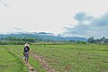
 Fizono, a village of Maroantsetra
 -
 Sahamadia
 -
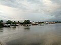 Harbour
 -

-


Wikimedia Commons has media related to Maroantsetra.
References
- ^ Pierre Van den Boogaerde (2011). Shipwrecks of Madagascar. Strategic Book. p. 141. ISBN 9781612043395.
- ^ Google (1 February 2020). "Maroantsetra" (Map). Google Maps. Google. Retrieved 1 February 2020.
- ^ Tammy Gagne (2012). We Visit Madagascar. Mitchell Lane Publishers. p. 17. ISBN 9781612283791.
- ^ "Flights & getting there". Lonely Planet. Retrieved 1 February 2020.
- v
- t
- e
Capital: Fenoarivo Atsinanana

6 districts; 71 communes
Authority control databases | |
|---|---|
| International |
|
| National |
|


