Makati–Mandaluyong Bridge
Bridge in Metro Manila, the Philippines
14°34′10″N 121°01′57″E / 14.5694°N 121.0325°E / 14.5694; 121.0325S04552LZ (southbound)
B04891LZ (bridge)[1]
0.29 km (0.18 mi) (road)[1]

The Makati–Mandaluyong Bridge is a four-lane road bridge crossing the Pasig River in Metro Manila, the Philippines. It connects P. Burgos Extension, a continuation of Makati Avenue in Barangay Poblacion, Makati at the south bank of the river to Coronado Street in Barangay Hulo, Mandaluyong at the north bank. The bridge was opened in 1986.[1]
The Hulo jeepney terminal, which serves intra-city jeepney and tricycle routes in Mandaluyong, was established in 2015 and can be found under and adjacent to the bridge.[5] Until the opening of the Estrella–Pantaleon Bridge in 2011, the Makati–Mandaluyong Bridge was the only bridge connecting the two cities other than the Guadalupe Bridge that carries EDSA.[6]
Gallery
-
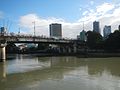 The bridge as seen from the north bank
 -
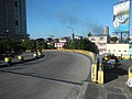
 Pedestrian access for the bridge from Mandaluyong
 -
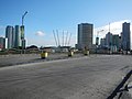
 The bridge approaching Makati
 -
 The bridge approaching Mandaluyong
 -
 Bridge pier
 -
 Road bridge


References
- ^ a b c d "Metro Manila 2nd". www.dpwh.gov.ph. Retrieved November 21, 2021.
- ^ "The study on the improvement of existing bridges along Pasig River and Marikina River in the Republic of the Philippines final report". Japan International Cooperation Agency: Part II - Masterplan, page 20. July 2004.
- ^ a b c d e "Road and Bridge Inventory". www.dpwh.gov.ph. Retrieved November 21, 2021.
- ^ "The project for study on improvement of bridges through disaster mitigating measures for large scale earthquakes in the Republic of the Philippines final report". Japan International Cooperation Agency: 25. December 2013.
- ^ "Hulo jeepney & tricycle terminal with park inaugurated". Mandaluyong City Government. Retrieved September 15, 2022.
- ^ "More bridges across Pasig". Philstar.com. Retrieved November 21, 2021.
- v
- t
- e
| Expressway routes | |||||
|---|---|---|---|---|---|
| Highway routes |
| ||||
| Arterial routes | |||||
| Major interchanges | |||||
| Bridges |
| ||||
| Roundabouts | |||||
| Planned | |||||
| Under construction |

  | This article about a bridge in the Philippines is a stub. You can help Wikipedia by expanding it. |
- v
- t
- e


