Llanddew

Llanddew is a small village and community about 2 km or 1 mile north-east of Brecon, Powys, Wales. The population as of the 2011 UK Census was 232. It is in the historic county of Brecknockshire (Breconshire).
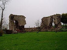
Its manor belongs to the Bishops of Saint Davids, who formerly had a residence or bishop's palace there, of which some ruins still remain. These incorporate a double-sided vaulted well, known as Bishop Gower's Well.
Llanddew Palace was the favoured residence of 12th-13th century clergyman and author Giraldus Cambrensis (Gerald of Wales), and hosted the Archbishop of Canterbury Baldwin of Exeter in 1188 during his mission through Wales recruiting for the Crusades.
St David's parish church in Llanddew is the oldest church in the historic county of Brecknockshire.[citation needed] The building dates from around the 13th century and has a cruciform shape, with a central tower. At one time, there were monastic buildings at the church, and the monks would go around the local area preaching and giving communion.
References
External links
Wikimedia Commons has media related to Llanddew.
Wikimedia Commons has media related to Bishop's Palace, Llanddew.
Wikimedia Commons has media related to St David's Church, Llanddew.
- Photos of Llanddew and surrounding area on geograph.org.uk
51°58′02″N 3°22′35″W / 51.9671°N 3.3763°W / 51.9671; -3.3763
- v
- t
- e
Powys
- Brecon
- Builth Wells
- Crickhowell
- Hay-on-Wye
- Knighton
- Llandrindod Wells
- Llanfair Caereinion
- Llanfyllin
- Llanidloes
- Llanwrtyd Wells
- Machynlleth
- Montgomery
- Newtown
- Presteigne
- Rhayader
- Talgarth
- Welshpool
- Ystradgynlais

- Abbey Cwmhir
- Aberedw
- Aberhafesp
- Abermule with Llandyssil
- Banwy
- Bausley with Criggion
- Beguildy
- Berriew
- Bettws
- Brecon
- Bronllys
- Builth
- Cadfarch
- Caersws
- Carno
- Carreghofa
- Castle Caereinion
- Churchstoke
- Cilmery
- Clyro
- Cray
- Crickhowell
- Cwmdu and District
- Disserth and Trecoed
- Duhonw
- Dwyriw
- Erwood
- Felin-fach
- Forden with Leighton and Trelystan
- Gladestry
- Glantwymyn
- Glasbury
- Glascwm
- Glyn Tarell
- Guilsfield
- Gwernyfed
- Hay
- Honddu Isaf
- Kerry
- Knighton
- Llanafan Fawr
- Llanbadarn Fawr
- Llanbadarn Fynydd
- Llanbister
- Llanbrynmair
- Llanddew
- Llanddewi Ystradenny
- Llandinam
- Llandrindod Wells
- Llandrinio
- Llandysilio
- Llanelwedd
- Llanerfyl
- Llanfair Caereinion
- Llanfechain
- Llanfihangel
- Llanfihangel Rhydithon
- Llanfrynach
- Llanfyllin
- Llangamarch
- Llangattock
- Llangedwyn
- Llangors
- Llangunllo
- Llangurig
- Llangynidr
- Llangyniew
- Llangynog
- Llanidloes
- Llanidloes Without
- Llanigon
- Llanrhaeadr-ym-Mochnant
- Llansantffraid
- Llansilin
- Llanwddyn
- Llanwrthwl
- Llanwrtyd Wells
- Llanyre
- Llywel
- Machynlleth
- Maescar
- Manafon
- Meifod
- Merthyr Cynog
- Mochdre with Penstrowed
- Montgomery
- Nantmel
- New Radnor
- Newtown and Llanllwchaiarn
- Old Radnor
- Painscastle
- Pen-y-bont-fawr
- Penybont
- Presteigne
- Rhayader
- St Harmon
- Talgarth
- Talybont-on-Usk
- Tawe-Uchaf
- Trallong
- Trefeglwys
- Treflys
- Tregynon
- Trewern
- Vale of Grwyney
- Welshpool
- Whitton
- Yscir
- Ystradfellte
- Ystradgynlais
- Abbeycwmhir
- Aber Clydach
- Aberbechan
- Aberbran
- Abercegir
- Abercraf
- Abercynllaith
- Aberedw
- Abergwesyn
- Abergwydol
- Aberhafesp
- Aberhosan
- Abermule
- Abernant
- Abertridwr
- Aberyscir
- Adfa
- Aithnen
- Arddlin
- Bacheldre
- Beguildy
- Berriew
- Bettws Cedewain
- Beulah
- Bont Dolgadfan
- Boughrood
- Bronllys
- Builth Wells
- Burgedin
- Buttington
- Bwlch
- Caehopkin
- Caersws
- Capel-y-ffin
- Carno
- Cathedine
- Cefnllys
- Cemmaes Road
- Church Stoke
- Cilmery
- Clatter
- Clyro
- Coelbren
- Commins Coch
- Crickhowell
- Criggion
- Crossgates
- Cwmdauddwr
- Cwmdu
- Cwmtwrch
- Cwmwysg
- Cwrt-y-Gollen
- Derwenlas
- Dolanog
- Dolfach
- Dolyhir
- Dylife
- Erwood
- Esgairgeiliog
- Forge
- Four Crosses, Montgomeryshire
- Four Crosses, Llanfair Caereinion
- Gladestry
- Glasbury
- Hay-on-Wye
- Heartsease (Knighton)
- Heartsease (Llanddewi Ystradenni)
- Heol Senni
- Kerry
- Knucklas
- Libanus
- Llan
- Llanafan Fawr
- Llanbrynmair
- Llanddew
- Llandinam
- Llandrinio
- Llandysilio
- Llanelwedd
- Llanfair Caereinion
- Llanfechain
- Llanfihangel Nant Bran
- Llanfihangel Talyllyn
- Llanfyllin
- Llangadfan
- Llangammarch Wells
- Llangedwyn
- Llangors
- Llangurig
- Llangynidr
- Llangynog
- Llangynyw
- Llanllwchaiarn
- Llanrhaeadr-ym-Mochnant
- Llansantffraed
- Llansanffraid-ym-Mechain
- Llansilin
- Llanwchaiarn
- Llanwrin
- Llanwrthwl
- Llanwrtyd Wells
- Llanwrtyd
- Llanymynech
- Llanyre
- Llawryglyn
- Llyswen
- Llywel
- Meifod
- Milebrook
- Morben
- Nant Glas
- New Radnor
- Newbridge-on-Wye
- Newchurch
- Old Church Stoke
- Painscastle
- Pandy
- Pant-y-Dwr
- Partrishow
- Penegoes
- Pennant
- Penwyllt
- Penybont
- Pilleth
- Plas Esgair
- Pont Crugnant
- Pontdolgoch
- Pontrobert
- Sarn
- Sennybridge
- Soar
- St Harmon
- Staylittle
- Sycharth
- Talerddig
- Talgarth
- Talybont-on-Usk
- Three Cocks
- Tirabad
- Trecastle
- Trefeglwys
- Tregynon
- Trewern
- Tylwch
- Van, Llanidloes
- Ystradfellte
- Parliamentary constituencies
- Electoral wards
- Places
- Schools
- SSSIs
- Scheduled Monuments
- Country houses
- Listed buildings
- Registered parks and gardens
- Lord Lieutenants
- High Sheriffs
- Museums
- Public art
 Geography
 Wales
Wales


 | This Powys location article is a stub. You can help Wikipedia by expanding it. |
- v
- t
- e


