Ljubljanica
River in Slovenia
45°57′5″N 14°17′41″E / 45.95139°N 14.29472°E / 45.95139; 14.29472, Ljubija45°57′11″N 14°18′0″E / 45.95306°N 14.30000°E / 45.95306; 14.30000, Bistra
• location
• coordinates
• elevation
The Ljubljanica (pronounced [ljuˈbljáːnitsa]), known in the Middle Ages as the Leybach,[3] is a river in the southern part of the Ljubljana Basin in Slovenia. The capital of Slovenia, Ljubljana, lies on the river. The Ljubljanica rises south of the town of Vrhnika and flows into the Sava River about 10 kilometres (6.2 mi) downstream from Ljubljana. Its largest affluent is the Mali Graben Canal.[4] Including its source affluent the Little Ljubljanica (Slovene: Mala Ljubljanica), the river is 41 km (25 mi) in length.[1] The Little Ljubljanica joins the Big Ljubljanica (Slovene: Velika Ljubljanica) after 1,300 m (4,300 ft) and the river continues its course as the Ljubljanica.
The Ljubljanica is the continuation of several karst rivers that flow from the Prezid Karst Field (Slovene: Prezidsko polje) to Vrhnika on the surface and underground in caves, and so the river is poetically said to have seven names (six name changes): Trbuhovica, Obrh, Stržen, Rak, Pivka, Unica, and Ljubljanica.
Archaeological significance
The Ljubljanica has become a popular site for archaeologists and treasure hunters to dive for lost relics and artifacts. Locations in the river between Ljubljana and Vrhnika have offered up pieces of history from the Stone Age to the Renaissance, belonging to a variety of groups, from local ancient cultures to more well-known groups like the Romans and the Celts.[5] One of the more significant findings is a yew spearhead, found in 2009 in Sinja Gorica. It has been dated to about 35,000 to 45,000 before present, the Szeletian period, and supplements the scant data about the presence of Stone Age hunters in the Ljubljana Marsh area.[6]
Exactly why the Ljubljanica became an article dumping ground is unknown, but most historians believe that it is related to how local tradition has always held the river as a sacred place. These treasures may have been offered "to the river during rites of passage, in mourning, or as thanksgiving for battles won."
The Ljubljanica has become a popular attraction in Europe for treasure hunters. This has created an ethical debate between local historians and international treasure seekers. It is believed that the river has offered up between 10,000 and 13,000 objects, of which many have been lost to the public. Many pieces have been sold into private collections, or are hidden away by the original treasure hunters. In 2003, to help curb this trend, Slovenia's national parliament declared the river a site of cultural importance and banned diving in it without a permit.
Gallery
- The Ljubljanica at Nove Fužine
-
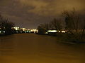 Night view of the river
 -
 Reflection of houses at the Cankar Embankment
 -
 Center of Ljubljana with Annunciation Church in the background
 -
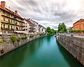 The Ljubljanica from the Cobbler Bridge in Ljubljana
 -
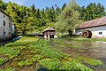 One of the springs of the Ljubljanica at Bistra Castle near Vrhnika
 -
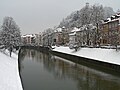 The Ljubljanica under the snow
 -
 Confluence of the Ljubljanica (left) with the Sava and Kamnik Bistrica


See also
References
- ^ a b c d Rivers, longer than 25 km, and their catchment areas, Statistical Office of the Republic of Slovenia
- ^ "Sava River Basin Analysis Report" (PDF). International Sava River Basin Commission. September 2009. p. 13. Archived from the original (PDF, 9.98 MB) on 17 July 2010.
- ^ Snoj, Marko (2009). Etimološki slovar slovenskih zemljepisnih imen. Ljubljana: Modrijan. p. 239.
- ^ "Občinski program varnosti občine Brezovica" [Municipal programme of the Municipality of Brezovica] (in Slovenian). 2010. p. 35. Archived from the original on 19 July 2011. Retrieved 20 September 2010.
- ^ Kaufmann, Carol (Jan 2007). "A River's Gifts". National Geographic Magazine. 150-7.
- ^ "Na Barju našli leseno ost sulice, staro 38.000 do 45.000 let" [A 38,000 to 45,000 Year Old Wooden Spearhead Found in the Ljubljana Marsh] (in Slovenian). Slovenian Press Agency. 6 May 2009. Retrieved 7 January 2011.
External links
Wikimedia Commons has media related to Ljubljanica.
- Condition of Ljubljanica - graphs, in the following order, of water level, flow and temperature data for the past 30 days (taken in Moste by ARSO)
- https://web.archive.org/web/20070311005227/http://expo98.literal.si/eng/zakladi/vode-slovenije/ljubljanica.html
- https://web.archive.org/web/20081011222409/http://www7.nationalgeographic.com/ngm/0701/feature6/index.html
- v
- t
- e
- BTC City
- Central Market
- Emonika
- Exhibition and Convention Centre
- Ljubljana Castle funicular
- Ljubljana Passenger Transport
- Ljubljana railway station
- Ljubljana Ring Road
- Ljubljana Stock Exchange
- Nama
- Trams
| Bridges | |
|---|---|
| Monuments, memorials and fountains |
|
| Palaces and houses |
|
| Churches and places of worship |
|
| Cemeteries |
| Parks | |
|---|---|
| Ponds | |
| Squares |
|
| Streets |
| Landscape parks |
|
|---|---|
| Nature reserves |
|
| Natural monuments |
|
| Designed nature monuments |
- Kucja Valley
- Mount Saint Mary
- Rožnik
- Anton Melik Geographical Institute
- Archives of the Republic of Slovenia
- Biennial of Graphic Arts
- Botanical Garden
- Cankar Centre
- Rog factory
- International Centre of Graphic Arts
- Jakopič Pavilion
- Jožef Stefan Institute
- Ljubljana International Film Festival
- Kiberpipa
- Križanke
- Ljubljana Slovene National Theatre Drama
- Ljubljana Slovene National Theatre Opera and Ballet
- Ljubljana Opera House
- Ljubljana Summer Festival
- Metelkova
- Museum of Contemporary History
- Museum of Modern Art
- The Naked Stage
- National Gallery
- National and University Library
- National Museum
- Poligon
- Slovenian Academy of Sciences and Arts
- Natural History Museum
- Slovenian Philharmonic Orchestra
- Slovenian Railway Museum
- St. Stanislaus Institute
- University of Ljubljana
- Zoo
the administrative seat
- Besnica
- Brezje pri Lipoglavu
- Češnjica
- Črna Vas
- Dolgo Brdo
- Dvor
- Gabrje pri Jančah
- Janče
- Javor
- Lipe
- Mali Lipoglav
- Mali Vrh pri Prežganju
- Malo Trebeljevo
- Medno
- Pance
- Podgrad
- Podlipoglav
- Podmolnik
- Prežganje
- Rašica
- Ravno Brdo
- Repče
- Sadinja Vas
- Selo pri Pancah
- Šentpavel
- Spodnje Gameljne
- Srednje Gameljne
- Stanežiče
- Toško Čelo
- Tuji Grm
- Veliki Lipoglav
- Veliko Trebeljevo
- Vnajnarje
- Volavlje
- Zagradišče
- Zgornja Besnica
- Zgornje Gameljne
- Bizovik
- Bokalce
- Brod (Črnuče District)
- Brod (Šentvid District)
- Črnuče
- Dobrava pri Črnučah
- Dobrunje
- Dolnice
- Dravlje
- Fužine
- Glince
- Glinica
- Gmajna
- Grič
- Gunclje
- Hradeckega Vas
- Hrastje
- Jarše
- Ježa
- Ježica
- Kamna Gorica
- Kleče
- Koseze
- Kozarje
- Laze
- Mala Vas
- Moste
- Nadgorica
- Obrije
- Podboršt
- Podgora
- Podgorica pri Črnučah
- Podutik
- Poljane (Šentvid District)
- Polje
- Pržan
- Rožna Dolina
- Rudnik
- Savlje
- Selo
- Šentjakob ob Savi
- Šentvid
- Slape
- Šmartno ob Savi
- Šmartno pod Šmarno Goro
- Sneberje
- Sostro
- Soteska
- Spodnja Hrušica
- Spodnja Šiška
- Spodnja Zadobrova
- Spodnji Kašelj
- Štepanja Vas
- Stožice
- Studenec
- Tacen
- Tomačevo
- Trata
- Vevče
- Vič
- Vižmarje
- Vodmat
- Vrhovci
- Zadvor
- Zalog
- Zapuže
- Zavoglje
- Zgornja Hrušica
- Zgornja Šiška
- Zgornja Zadobrova
- Zgornji Kašelj

Authority control databases | |
|---|---|
| International |
|
| National |
|


