List of historic places in Middlesex County, Ontario
Map all coordinates using OpenStreetMap
Download coordinates as:
- KML
- GPX (all coordinates)
- GPX (primary coordinates)
- GPX (secondary coordinates)
This is a list of historic places in Middlesex County, Ontario, containing heritage sites listed on the Canadian Register of Historic Places (CRHP), all of which are designated as historic places either locally, provincially, territorially, nationally, or by more than one level of government.
List of historic places
| Name | Address | Coordinates | Government recognition (CRHP №) | Image | |
|---|---|---|---|---|---|
| 37 Ridout Street South | 37 Ridout Street South London ON | 42°58′32″N 81°15′02″W / 42.9755°N 81.2506°W / 42.9755; -81.2506 (37 Ridout Street South) | London municipality (14087) |  More images | |
| 49 Ridout Street South | 49 Ridout Street South London ON | 42°58′29″N 81°15′00″W / 42.9748°N 81.25°W / 42.9748; -81.25 (49 Ridout Street South) | London municipality (14883) |  More images | |
| 64 Elmwood Avenue East | 64 Elmwood Avenue East London ON | 42°58′14″N 81°15′29″W / 42.9705°N 81.2581°W / 42.9705; -81.2581 (64 Elmwood Avenue East) | London municipality (14284) |  | |
| 85 Albion Street | 85 Albion Street London ON | 42°59′19″N 81°15′42″W / 42.9886°N 81.2616°W / 42.9886; -81.2616 (85 Albion Street) | London municipality (14365) |  | |
| 165 Oxford Street East | 165 Oxford Street East London ON | 42°59′42″N 81°15′18″W / 42.995°N 81.255°W / 42.995; -81.255 (165 Oxford Street East) | London municipality (14046) |  | |
| 260 Sydenham Street | 260 Sydenham Street London ON | 42°59′50″N 81°15′06″W / 42.9972°N 81.2517°W / 42.9972; -81.2517 (260 Sydenham Street) | London municipality (14086) |  More images | |
| 308 Princess Avenue | 308 Princess Avenue London ON | 42°59′22″N 81°14′42″W / 42.9895°N 81.2451°W / 42.9895; -81.2451 (308 Princess Avenue) | London municipality (14864) | 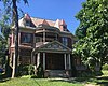 | |
| 350 Talbot Street | 350 Talbot Street London ON | 42°58′53″N 81°15′03″W / 42.9813°N 81.2509°W / 42.9813; -81.2509 (350 Talbot Street) | London municipality (14865) |  | |
| 379 Wortley Road | 379 Wortley Road London ON | 42°57′46″N 81°14′51″W / 42.9627°N 81.2474°W / 42.9627; -81.2474 (379 Wortley Road) | London municipality (14871) | 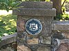 | |
| 398 Piccadilly Street | 398 Piccadilly Street London ON | 42°59′48″N 81°14′42″W / 42.9966°N 81.245°W / 42.9966; -81.245 (398 Piccadilly Street) | London municipality (14872) | 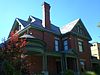 More images | |
| 437 Victoria Street | 437 Victoria Street London ON | 43°00′23″N 81°14′52″W / 43.0063°N 81.2477°W / 43.0063; -81.2477 (437 Victoria Street) | London municipality (14089) | 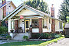 | |
| 496 Waterloo Street | 496 Waterloo Street London ON | 42°59′23″N 81°14′40″W / 42.9896°N 81.2444°W / 42.9896; -81.2444 (496 Waterloo Street) | London municipality (14090) | 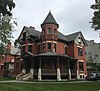 | |
| 501-503 Colborne Street | 501 Colborne Street London ON | 42°59′18″N 81°14′28″W / 42.9883°N 81.2411°W / 42.9883; -81.2411 (501-503 Colborne Street) | London municipality (14884) | 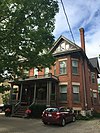 | |
| 527 Princess Avenue | 527 Princess Avenue London ON | 42°59′31″N 81°14′11″W / 42.9919°N 81.2364°W / 42.9919; -81.2364 (527 Princess Avenue) | London municipality (14283) | 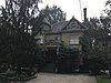 | |
| The Aeolian Hall | 795 Dundas Street London ON | 42°59′27″N 81°13′30″W / 42.9907°N 81.2249°W / 42.9907; -81.2249 (The Aeolian Hall) | London municipality (4402) | 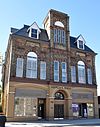 More images | |
| Banting House National Historic Site of Canada | 442 Adelaide Street North London ON | 42°59′23″N 81°13′54″W / 42.9896°N 81.2318°W / 42.9896; -81.2318 (Banting House National Historic Site of Canada) | Federal (4021) |  More images | |
| Baty House | 700 Pond Mills Road London ON | 42°56′40″N 81°11′37″W / 42.9444°N 81.1937°W / 42.9444; -81.1937 (Baty House) | London municipality (10781) |  | |
| Beth-Emmanuel British Methodist Episcopal Church | 430 Grey Street London ON | 42°58′48″N 81°14′06″W / 42.9799°N 81.2351°W / 42.9799; -81.2351 (Beth-Emmanuel British Methodist Episcopal Church) | London municipality (8429) |  More images | |
| Bishop Hellmuth Heritage Conservation District | Bishop Hellmuth Heritage Conservation District London ON | 42°59′56″N 81°15′03″W / 42.9989°N 81.2508°W / 42.9989; -81.2508 (Bishop Hellmuth Heritage Conservation District) | London municipality (10788) |  | |
| Blackfriars Bridge | Blackfriars Street London ON | 42°59′20″N 81°15′26″W / 42.989°N 81.2573°W / 42.989; -81.2573 (Blackfriars Bridge) | London municipality (10079) | 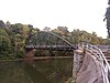 More images | |
| Brick Street Cemetery | 370 Commissioners Road West London ON | 42°57′19″N 81°16′50″W / 42.9554°N 81.2805°W / 42.9554; -81.2805 (Brick Street Cemetery) | London municipality (15190) |  | |
| Buchan House | 566, Dundas Street London ON | London municipality (8569) |  More images | ||
| Carfrae Cottage | 39 Carfrae Street London ON | 42°58′27″N 81°14′51″W / 42.9742°N 81.2474°W / 42.9742; -81.2474 (Carfrae Cottage) | London municipality (10811) | 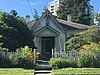 | |
| Carling House | 36 Grosvenor Street London ON | 42°59′58″N 81°15′21″W / 42.9995°N 81.2557°W / 42.9995; -81.2557 (Carling House) | London municipality (10814) | 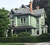 | |
| Chestnut Hill | 55 Centre Street London ON | 42°57′37″N 81°15′53″W / 42.9602°N 81.2648°W / 42.9602; -81.2648 (Chestnut Hill) | London municipality (10904) |  More images | |
| Christ Anglican Church | 138 Wellington Street London ON | 42°58′37″N 81°14′27″W / 42.977°N 81.2408°W / 42.977; -81.2408 (Christ Anglican Church) | London municipality (10183) | 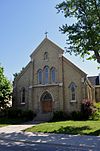 More images | |
| Crooks Property | 22 Peter Street London ON | 42°59′23″N 81°14′11″W / 42.9897°N 81.2363°W / 42.9897; -81.2363 (Crooks Property) | London municipality (10910) | 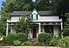 | |
| Curnoe Property | 38 Weston Street London ON | 42°58′13″N 81°14′02″W / 42.9704°N 81.234°W / 42.9704; -81.234 (Curnoe Property) | London municipality (15305) |  | |
| Dominion Public Building | 457 Richmond Street London ON | 42°59′06″N 81°15′04″W / 42.9851°N 81.2511°W / 42.9851; -81.2511 (Dominion Public Building) | Federal (3326), London municipality (10956) | 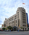 | |
| Dundas Centre United Church | 482 Dundas Street London ON | 42°59′16″N 81°14′12″W / 42.9877°N 81.2367°W / 42.9877; -81.2367 (Dundas Centre United Church) | London municipality (10958) | 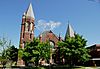 | |
| East Woodfield Heritage Conservation District | London ON | 42°59′28″N 81°14′10″W / 42.9912°N 81.2362°W / 42.9912; -81.2362 (East Woodfield Heritage Conservation District) | London municipality (10974) |  Upload Photo | |
| Eldon House | 481 Ridout Street London ON | 42°59′05″N 81°15′19″W / 42.9846°N 81.2554°W / 42.9846; -81.2554 (Eldon House) | London municipality (8075) | 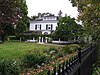 More images | |
| Elsie Perrin Williams Estate | 101 Windermere Road London ON | 43°00′37″N 81°17′28″W / 43.0103°N 81.2912°W / 43.0103; -81.2912 (Elsie Perrin Williams Estate) | London municipality (11032) | 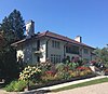 More images | |
| Elsie Perrin Williams Memorial Library | 305 Queens Avenue London ON | 42°59′11″N 81°14′39″W / 42.9863°N 81.2441°W / 42.9863; -81.2441 (Elsie Perrin Williams Memorial Library) | London municipality (11193) |  | |
| Fire Hall No. 5 | 155 Adelaide Street North London ON | 42°58′52″N 81°13′43″W / 42.981°N 81.2285°W / 42.981; -81.2285 (Fire Hall No. 5) | London municipality (11219) | 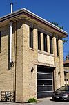 | |
| First Christian Reformed Church | 513 Talbot Street London ON | 42°59′11″N 81°15′14″W / 42.9865°N 81.2539°W / 42.9865; -81.2539 (First Christian Reformed Church) | London municipality (11220) | 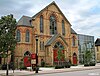 | |
| Flint Cottage and Flint Shelter | 1097 Commissioners Road West London ON | 42°57′26″N 81°19′21″W / 42.9571°N 81.3224°W / 42.9571; -81.3224 (Flint Cottage and Flint Shelter) | London municipality (11222) | 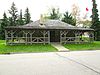 | |
| Forks of the Thames Interpretive Centre | 1 Dundas Street London ON | 42°58′54″N 81°15′21″W / 42.9818°N 81.2559°W / 42.9818; -81.2559 (Forks of the Thames Interpretive Centre) | London municipality (11622) |  | |
| Goodholme | 291 Epworth Avenue London ON | 43°00′41″N 81°15′26″W / 43.0113°N 81.2571°W / 43.0113; -81.2571 (Goodholme) | London municipality (10868) | 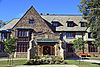 More images | |
| Grand Theatre | 471 Richmond Street London ON | 42°59′09″N 81°15′03″W / 42.9859°N 81.2509°W / 42.9859; -81.2509 (Grand Theatre) | London municipality (13715) | 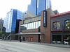 | |
| Grosvenor Lodge | 1017 Western Road London ON | 42°59′42″N 81°16′23″W / 42.9951°N 81.273°W / 42.9951; -81.273 (Grosvenor Lodge) | London municipality (10091) |  More images | |
| Hayman House | 869 Dundas Street London ON | 42°59′36″N 81°13′20″W / 42.9933°N 81.2221°W / 42.9933; -81.2221 (Hayman House) | London municipality (11632) | Upload Photo | |
| J. Allyn Taylor Building | 267 Dundas Street London ON | 42°59′05″N 81°14′44″W / 42.9846°N 81.2455°W / 42.9846; -81.2455 (J. Allyn Taylor Building) | London municipality (13718) | 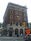 | |
| Labatt Memorial Park | 25 Wilson Avenue London ON | 42°59′01″N 81°15′30″W / 42.9835°N 81.2584°W / 42.9835; -81.2584 (Labatt Memorial Park) | London municipality (10078) | 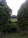 | |
| Lawson Site | 1600 Attawandaron Road London ON | 43°00′45″N 81°18′00″W / 43.0125°N 81.3°W / 43.0125; -81.3 (Lawson Site) | Ontario (1504) |  More images | |
| Loew's London Theatre | 194 Dundas London ON | 42°59′03″N 81°14′54″W / 42.9842°N 81.2483°W / 42.9842; -81.2483 (Loew's London Theatre) | London municipality (14367) | 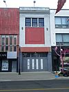 | |
| London and Western Trusts | 353 Richmond Street London ON | 42°58′56″N 81°14′57″W / 42.9821°N 81.2491°W / 42.9821; -81.2491 (London and Western Trusts) | London municipality (11689) |  | |
| London Mechanics Institute Building | 229 Dundas Street London ON | 42°59′03″N 81°14′49″W / 42.9843°N 81.2469°W / 42.9843; -81.2469 (London Mechanics Institute Building) | London municipality (11682) | 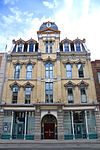 | |
| London Normal School | 165 Elmwood Avenue East London ON | 42°58′14″N 81°15′04″W / 42.9706°N 81.2512°W / 42.9706; -81.2512 (London Normal School) | Ontario (8871) | 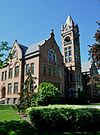 More images | |
| London Psychiatric Hospital | 850 Highbury Avenue North London ON | 43°00′14″N 81°12′16″W / 43.0038°N 81.2044°W / 43.0038; -81.2044 (London Psychiatric Hospital) | London municipality (11684) | 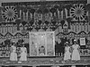 | |
| London Tower | 379 Dundas Street London ON | 42°59′09″N 81°14′25″W / 42.9857°N 81.2404°W / 42.9857; -81.2404 (London Tower) | London municipality (11681) |  | |
| McClary Cottage (95 High Street) | 95 High Street London ON | 42°58′14″N 81°14′18″W / 42.9705°N 81.2384°W / 42.9705; -81.2384 (McClary Cottage (95 High Street)) | London municipality (14480) | 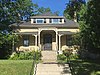 More images | |
| McClary Cottage (97 High Street) | 97 High Street London ON | 42°58′14″N 81°14′18″W / 42.9705°N 81.2384°W / 42.9705; -81.2384 (McClary Cottage (97 High Street)) | London municipality (14484) | 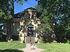 More images | |
| McClary House | 53 McClary London ON | 42°58′14″N 81°14′18″W / 42.9705°N 81.2384°W / 42.9705; -81.2384 (McClary House) | London municipality (14384) | 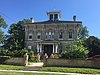 More images | |
| Middlesex County Court House | 399 Ridout Street North, Ward 13 London ON | 42°58′56″N 81°15′15″W / 42.9821°N 81.2543°W / 42.9821; -81.2543 (Middlesex County Court House) | Federal (13537), Ontario (8873) |  More images | |
| New Brighton Housing Co-operative | 473 Baker London ON | 42°58′05″N 81°14′28″W / 42.968°N 81.2411°W / 42.968; -81.2411 (New Brighton Housing Co-operative) | London municipality (14443) |  More images | |
| Norton Attawandaron Site | 150 Chelsea Avenue London ON | 42°58′18″N 81°16′44″W / 42.9718°N 81.279°W / 42.9718; -81.279 (Norton Attawandaron Site) | London municipality (13721) | 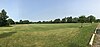 | |
| ‘O’ Block, Wolseley Barracks | London ON | 43°00′00″N 81°14′00″W / 43°N 81.2333°W / 43; -81.2333 (‘O’ Block, Wolseley Barracks) | Federal (11281) | Upload Photo | |
| Old East Heritage Conservation District | London ON | 42°59′38″N 81°13′35″W / 42.9939°N 81.2264°W / 42.9939; -81.2264 (Old East Heritage Conservation District) | London municipality (11863) | 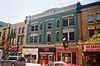 | |
| Old Waterloo South Primary Public School | 186 Waterloo Street London ON | 42°58′45″N 81°14′19″W / 42.9791°N 81.2387°W / 42.9791; -81.2387 (Old Waterloo South Primary Public School) | London municipality (13724) | 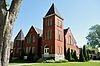 | |
| Palace Theatre | 710 Dundas Street London ON | 42°59′24″N 81°13′41″W / 42.9901°N 81.228°W / 42.9901; -81.228 (Palace Theatre) | London municipality (11868) | 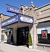 | |
| Park Farm | 120 Meadowlily Road South London ON | 42°57′59″N 81°11′06″W / 42.9664°N 81.185°W / 42.9664; -81.185 (Park Farm) | London municipality (11881) | Upload Photo | |
| Philip Aziz Property | 150 Philip Aziz Avenue London ON | 43°00′08″N 81°16′31″W / 43.0022°N 81.2752°W / 43.0022; -81.2752 (Philip Aziz Property) | London municipality (15471) |  More images | |
| Raleigh House | 639 Barton Street London ON | 42°59′31″N 81°15′22″W / 42.9919°N 81.2561°W / 42.9919; -81.2561 (Raleigh House) | London municipality (12428) | Upload Photo | |
| Ridout Street Complex National Historic Site of Canada | Ridout Street North London ON | 42°59′03″N 81°15′18″W / 42.9842°N 81.255°W / 42.9842; -81.255 (Ridout Street Complex National Historic Site of Canada) | Federal (12873) | 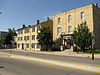 | |
| St. Paul's Cathedral | 472 Richmond Street London ON | 42°59′09″N 81°14′59″W / 42.9857°N 81.2497°W / 42.9857; -81.2497 (St. Paul's Cathedral) | London municipality (15473) |  More images | |
| St. Peter's Seminary | 1040 Waterloo Street London ON | 43°00′44″N 81°15′12″W / 43.0122°N 81.2534°W / 43.0122; -81.2534 (St. Peter's Seminary) | London municipality (8072) | 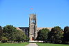 More images | |
| Scottsville Cemetery | 5190 Colonel Talbot Road London ON | 42°53′11″N 81°17′22″W / 42.8865°N 81.2895°W / 42.8865; -81.2895 (Scottsville Cemetery) | London municipality (13725) | 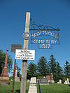 | |
| Sterling Place | 330 Clarence Street London ON | 42°58′56″N 81°14′46″W / 42.9821°N 81.2461°W / 42.9821; -81.2461 (Sterling Place) | London municipality (13191) | 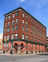 | |
| Substation No. 4 | 119 Carling Street London ON | 42°59′01″N 81°15′06″W / 42.9837°N 81.2516°W / 42.9837; -81.2516 (Substation No. 4) | London municipality (13252) | 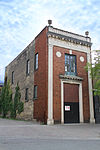 | |
| T Block | 650 Elizabeth Street London ON | 42°59′50″N 81°13′56″W / 42.9971°N 81.2323°W / 42.9971; -81.2323 (T Block) | London municipality (14943) | 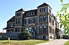 More images | |
| Thornwood | 329 St. George Street London ON | 42°59′59″N 81°15′28″W / 42.9998°N 81.2579°W / 42.9998; -81.2579 (Thornwood) | London municipality (13251) | 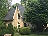 | |
| Victoria Park | 580 Clarence Street London ON | 42°59′22″N 81°14′56″W / 42.9895°N 81.2490°W / 42.9895; -81.2490 (Victoria Park) | London municipality (10655) |  More images | |
| Waverly | 10 Grand Avenue London ON | 42°58′19″N 81°14′49″W / 42.9719°N 81.2469°W / 42.9719; -81.2469 (Waverly) | London municipality (10592) | 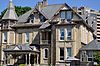 | |
| Wolseley Barracks | London ON | 42°59′55″N 81°13′59″W / 42.9986°N 81.2331°W / 42.9986; -81.2331 (Wolseley Barracks) | Federal (3310) | 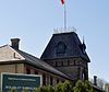 | |
| Wolseley Barracks National Historic Site of Canada | London ON | 43°00′N 81°13′W / 43°N 81.21°W / 43; -81.21 (Wolseley Barracks National Historic Site of Canada) | Federal (14341) | | |
| Parkhill National Historic Site of Canada | West Corner Drive and Prance Road Parkhill ON | 43°12′05″N 81°45′00″W / 43.2014°N 81.7501°W / 43.2014; -81.7501 (Parkhill National Historic Site of Canada) | Federal (10619) | Upload Photo | |
| Battle Hill National Historic Site of Canada | Longwoods Road, Highway 2 Southwest Middlesex ON | 42°41′39″N 81°42′20″W / 42.6941°N 81.7056°W / 42.6941; -81.7056 (Battle Hill National Historic Site of Canada) | Federal (13217) | 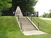 More images |
See also
Wikimedia Commons has media related to Cultural heritage monuments in Ontario.


