List of crossings of the River Ribble
This is a list of crossings of the River Ribble in Northern England.
| Status | Criteria[1] |
|---|---|
| II* | Grade II* listed. Particularly important bridge of more than special interest |
| II | Grade II listed. Bridge of national importance and special interest |
Map all coordinates using OpenStreetMap
Download coordinates as:
- KML
- GPX (all coordinates)
- GPX (primary coordinates)
- GPX (secondary coordinates)
| Crossing | Date | Coordinates | Heritage status | Locality | Notes | Image
|
|---|---|---|---|---|---|---|
| Ribblehead Viaduct | 1875 | 54°12′37″N 2°22′13″W / 54.2104°N 2.3702°W / 54.2104; -2.3702 (Ribblehead Viaduct) | II* | Ribblehead | Settle–Carlisle line Crosses head of valley, not strictly the river itself | 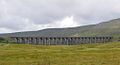 |
| Footbridge | 54°10′50″N 2°19′14″W / 54.1805°N 2.3206°W / 54.1805; -2.3206 (Selside Footbridge) | - | Selside |  | ||
| Pennine Bridleway Bridge | 54°10′22″N 2°18′49″W / 54.1729°N 2.3136°W / 54.1729; -2.3136 (Pennine Bridleway Bridge) | - | Selside | Pennine Bridleway | 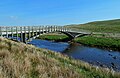
| |
| New Inn Bridge[2] | Late 18th Cent | 54°08′59″N 2°17′47″W / 54.1497°N 2.2964°W / 54.1497; -2.2964 (New Inn Bridge) | II | Horton in Ribblesdale | B6479 |  |
| Footbridge | 54°08′58″N 2°17′47″W / 54.1495°N 2.2964°W / 54.1495; -2.2964 (Horton Footbridge) | - | Horton in Ribblesdale |  | ||
| Footbridge | 54°08′13″N 2°17′56″W / 54.137°N 2.2989°W / 54.137; -2.2989 (Crag Hill Footbridge) | - | Crag Hill Farm | 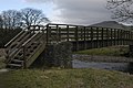 | ||
| Footbridge | 54°07′36″N 2°17′29″W / 54.1267°N 2.2915°W / 54.1267; -2.2915 (Studfold Footbridge) | - | Studfold | 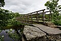 | ||
| Railway Bridge | 54°07′24″N 2°17′27″W / 54.1234°N 2.2909°W / 54.1234; -2.2909 (Helwith Bridge Railway Bridge) | - | Settle–Carlisle line | 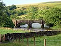 | ||
| Helwith Bridge[3] | 1875 | 54°07′17″N 2°17′25″W / 54.1214°N 2.2902°W / 54.1214; -2.2902 (Helwith Bridge) | II | Helwith Bridge | 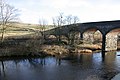 | |
| Farm Access Bridge | 54°07′00″N 2°17′24″W / 54.1168°N 2.29°W / 54.1168; -2.29 (Farm Access Bridge) | - | Helwith Bridge | |||
| Railway Bridge | 54°06′45″N 2°17′12″W / 54.1124°N 2.2867°W / 54.1124; -2.2867 (Railway Bridge) | - | Settle–Carlisle line | 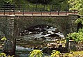 | ||
| Sheriff Brow Viaduct | 54°06′35″N 2°17′04″W / 54.1096°N 2.2844°W / 54.1096; -2.2844 (Sheriff Brow Viaduct) | - | Settle–Carlisle line | 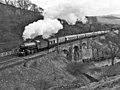 | ||
| Knight Stainforth Bridge[4] | Late 17th Cent | 54°06′03″N 2°16′48″W / 54.1008°N 2.2801°W / 54.1008; -2.2801 (Knight Stainforth Bridge) | II | Stainforth | 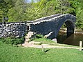 | |
| Holmehead Bridge | 54°05′03″N 2°16′50″W / 54.0843°N 2.2806°W / 54.0843; -2.2806 (Holmehead Bridge) | - | Locks Cottages Access | 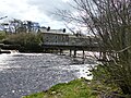 | ||
| Settle Bridge[5] | 17th Cent | 54°04′21″N 2°16′54″W / 54.0724°N 2.2818°W / 54.0724; -2.2818 (Settle Bridge) | II* | Settle | B6480 |  |
| Settle Footbridge | 54°04′21″N 2°16′55″W / 54.0724°N 2.282°W / 54.0724; -2.282 (Settle Footbridge) | - | Settle |  | ||
| Giggleswick Memorial Bridge | 54°04′15″N 2°17′08″W / 54.0707°N 2.2856°W / 54.0707; -2.2856 (Giggleswick Memorial Bridge) | - | Settle |  | ||
| Penny Bridge | 54°03′55″N 2°17′08″W / 54.0653°N 2.2855°W / 54.0653; -2.2855 (Penny Bridge) | - | Settle | |||
| A65 Bridge | 1988 | 54°03′18″N 2°17′33″W / 54.055°N 2.2926°W / 54.055; -2.2926 (A65 Bridge) | - | Settle | A65 | 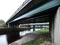 |
| Railway Bridge | 54°03′17″N 2°17′34″W / 54.0547°N 2.2927°W / 54.0547; -2.2927 (Settle Railway Bridge) | - | Settle | Leeds–Morecambe line | | |
| Cow Bridge[6] | Late 18th Cent | 54°00′31″N 2°15′54″W / 54.0085°N 2.2649°W / 54.0085; -2.2649 (Cow Bridge) | II | B6478 |  | |
| Halton Bridge[7] | Mid 18th Cent | 53°59′33″N 2°13′39″W / 53.9924°N 2.2275°W / 53.9924; -2.2275 (Halton Bridge) | II | 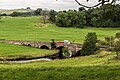 | ||
| Paythorne Bridge[8] | 17th Cent | 53°57′26″N 2°15′32″W / 53.9572°N 2.2589°W / 53.9572; -2.2589 (Paythorne Bridge) | II | Paythorne |  | |
| Gisburn Bridge[9] | 18th Cent | 53°56′33″N 2°16′22″W / 53.9424°N 2.2729°W / 53.9424; -2.2729 (Gisburn Bridge) | II | Gisburn | ||
| Sawley Bridge[10] | c.1800 | 53°54′54″N 2°20′39″W / 53.9151°N 2.3442°W / 53.9151; -2.3442 (Sawley Bridge) | II | Sawley |  | |
| Grindleton Bridge | 53°54′00″N 2°21′55″W / 53.9001°N 2.3652°W / 53.9001; -2.3652 (Grindleton Bridge) | - | Grindleton | 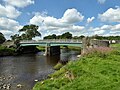 | ||
| West Bradford Bridge[11] | c. 1800 | 53°53′28″N 2°23′23″W / 53.891°N 2.3897°W / 53.891; -2.3897 (West Bradford Bridge) | II | West Bradford | 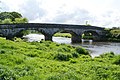 | |
| Brungerley Bridge | 53°52′52″N 2°23′57″W / 53.8811°N 2.3991°W / 53.8811; -2.3991 (Brungerley Bridge) | - | Clitheroe | B6478 |  | |
| Footbridge | 53°52′22″N 2°24′51″W / 53.8728°N 2.4142°W / 53.8728; -2.4142 (Clitheroe Footbridge) | - | Clitheroe |  | ||
| Edisford Bridge[12] | Late Medieval | 53°52′06″N 2°25′03″W / 53.8684°N 2.4176°W / 53.8684; -2.4176 (Edisford Bridge) | II | Clitheroe | B6243 |  |
| Aqueduct | 53°51′01″N 2°25′17″W / 53.8503°N 2.4214°W / 53.8503; -2.4214 (Aqueduct) | - | Whalley | Haweswater Aqueduct | 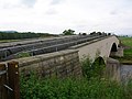 | |
| Mitton Bridge[13] | Early 19th Cent | 53°50′38″N 2°26′00″W / 53.844°N 2.4334°W / 53.844; -2.4334 (Mitton Bridge) | II | Little Mitton | B6246 | 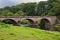 |
| Aqueduct | 53°49′51″N 2°28′11″W / 53.8309°N 2.4697°W / 53.8309; -2.4697 (Aqueduct) | - | 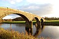 | |||
| New Dinckley Footbridge | 53°49′28″N 2°28′43″W / 53.8245°N 2.4785°W / 53.8245; -2.4785 (New Dinckley Footbridge) | - | Replaced earlier suspension bridge |  | ||
| Ribchester Bridge[14] | 1789 | 53°48′57″N 2°30′51″W / 53.8159°N 2.5143°W / 53.8159; -2.5143 (Ribchester Bridge) | II | Ribchester | B6245 | 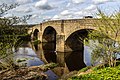 |
| Thirlmere Aqueduct[15] | 1891-2 | 53°46′43″N 2°36′39″W / 53.7785°N 2.6108°W / 53.7785; -2.6108 (Thirlmere Aqueduct) | - | Samlesbury | Thirlmere Aqueduct | |
| Samlesbury Bridge | 53°45′57″N 2°38′10″W / 53.7658°N 2.6362°W / 53.7658; -2.6362 (M6 Bridge) | - | Samlesbury | M6 motorway Main and slip road bridges | 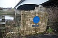 | |
| Brockholes Bridge | 53°45′54″N 2°38′38″W / 53.765°N 2.6439°W / 53.765; -2.6439 (A59 Bridge) | - | Preston | A59 | 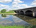 | |
| Walton Bridge[16] | 1781 | 53°45′10″N 2°40′46″W / 53.7528°N 2.6795°W / 53.7528; -2.6795 (Walton Bridge) | II | Preston | A6 | 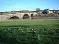 |
| Old Tramway Bridge | 53°45′07″N 2°41′48″W / 53.7519°N 2.6966°W / 53.7519; -2.6966 (Old Tramway Bridge) | - | Avenham Park, Preston | Former Lancaster Canal Tramroad. Pedestrian/cycle, closed since 2019; scheduled to be replaced |  | |
| Avenham Park Bridge | 1849 | 53°45′05″N 2°42′09″W / 53.7513°N 2.7025°W / 53.7513; -2.7025 (Avenham Park Bridge) | - | Avenham Park / Miller Park, Preston | Former East Lancashire Railway, now pedestrian/cycle |  |
| Preston Railway Viaduct[17] | 1838 | 53°44′59″N 2°42′22″W / 53.7497°N 2.7062°W / 53.7497; -2.7062 (Preston Railway Viaduct) | II | Miller Park, Preston | West Coast Main Line | 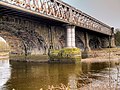 |
| Pipelines | 1881 | 53°44′55″N 2°42′48″W / 53.7486°N 2.7134°W / 53.7486; -2.7134 (West Lancashire Railway Bridge) | - | Preston | Former West Lancashire Railway. Only the pillars survive, supporting water and gas pipelines. | 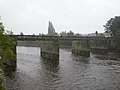 |
| Penwortham Old Bridge[18] | 1759 | 53°44′56″N 2°42′51″W / 53.7488°N 2.7141°W / 53.7488; -2.7141 (Old Penwortham Bridge) | II | Preston | Pedestrian/cycle |  |
| Penwortham New Bridge | 1912 | 53°45′14″N 2°43′04″W / 53.7538°N 2.7177°W / 53.7538; -2.7177 (Penwortham New Bridge) | - | Preston | B5254 | 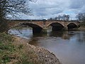 |
| Guild Way Bridge | c.1984 | 53°45′24″N 2°43′15″W / 53.7566°N 2.7209°W / 53.7566; -2.7209 (Guild Way Bridge) | - | Preston | A59 |  |
References
- ^ Listed Buildings, English Heritage, archived from the original on 9 December 2012, retrieved 22 April 2011
- ^ British Listed Buildings
- ^ British Listed Buildings
- ^ British Listed Buildings
- ^ British Listed Buildings
- ^ British Listed Buildings
- ^ British Listed Buildings
- ^ British Listed Buildings
- ^ British Listed Buildings
- ^ British Listed Buildings
- ^ Historic England. "West Bradford Bridge (1072162)". National Heritage List for England.
- ^ British Listed Buildings
- ^ British Listed Buildings
- ^ British Listed Buildings
- ^ Historic England. "Thirlmere Aqueduct (1463266)". Research records (formerly PastScape).
- ^ British Listed Buildings
- ^ British Listed Buildings
- ^ British Listed Buildings


