List of National Historic Landmarks in North Carolina
This is a List of National Historic Landmarks in North Carolina.
North Carolina has 39 National Historic Landmarks:
Map all coordinates using OpenStreetMap
Download coordinates as:
- KML
- GPX (all coordinates)
- GPX (primary coordinates)
- GPX (secondary coordinates)
| [1] | Landmark name | Image | Date designated[2] | Location | County | Description |
|---|---|---|---|---|---|---|
| 1 | Bentonville Battlefield |  | June 19, 1996 (#70000460) | Bentonville and Newton Grove 35°18′23″N 78°19′26″W / 35.306389°N 78.323889°W / 35.306389; -78.323889 (Bentonville Battlefield) | Johnston | Site of Battle of Bentonville |
| 2 | Bethabara |  | January 20, 1999 (#78001948) | Winston-Salem 36°09′16″N 80°17′55″W / 36.154444°N 80.298611°W / 36.154444; -80.298611 (Bethabara) | Forsyth | Area of 1753 Moravian settlement |
| 3 | Bethania Historic District |  | August 7, 2001 (#76001321) | Bethania 36°11′02″N 80°20′13″W / 36.183889°N 80.336944°W / 36.183889; -80.336944 (Bethania Historic District) | Forsyth | |
| 4 | Biltmore Estate | 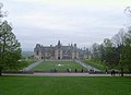 | May 23, 1963 (#66000586) | Asheville 35°32′23″N 82°33′03″W / 35.53965°N 82.55095°W / 35.53965; -82.55095 (Biltmore Estate) 35°32′23″N 82°33′03″W / 35.53965°N 82.55095°W / 35.53965; -82.55095 (Biltmore Estate) | Buncombe | Largest private residence in the united states. |
| 5 | W. T. Blackwell and Company Tobacco Factory |  | December 22, 1977 (#74001346) | Durham 35°59′44″N 78°54′14″W / 35.995457°N 78.903959°W / 35.995457; -78.903959 (W. T. Blackwell and Company Tobacco Factory) | Durham | Also known as Bull Durham Tobacco Factory. |
| 6 | Blandwood | 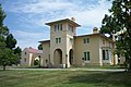 | June 7, 1988 (#70000455) | Greensboro 36°04′13″N 79°47′44″W / 36.070384°N 79.795425°W / 36.070384; -79.795425 (Blandwood) | Guilford | Former home of progressive North Carolina Governor John Motley Morehead, designed by New York architect Alexander Jackson Davis in the Italian Tuscan style. |
| 7 | Cape Hatteras Light Station |  | August 5, 1998 (#78000266) | Buxton 35°15′02″N 75°31′44″W / 35.250556°N 75.528806°W / 35.250556; -75.528806 (Cape Hatteras Light Station) | Dare | At 208 feet (63 m) tall, tallest lighthouse in the United States. |
| 8 | Capitol (North Carolina) |  | November 6, 1973 (#70000476) | Raleigh 35°46′52″N 78°38′20″W / 35.781249°N 78.638897°W / 35.781249; -78.638897 (Capitol (North Carolina)) | Wake | Capitol building, part of Capitol Area Historic District. |
| 9 | Chowan County Courthouse |  | April 15, 1970 (#70000447) | Edenton 36°03′28″N 76°36′29″W / 36.057889°N 76.607935°W / 36.057889; -76.607935 (Chowan County Courthouse) | Chowan | |
| 10 | Christ Episcopal Church |  | December 23, 1987 (#87002597) | Raleigh 35°46′52″N 78°38′16″W / 35.781146°N 78.637648°W / 35.781146; -78.637648 (Christ Episcopal Church) | Wake | Perhaps earliest Gothic architecture church in the South, designed in 1846 by Richard Upjohn |
| 11 | Connemara, The Carl Sandburg Farm | 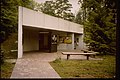 | May 23, 1968 (#68000013) | Flat Rock 35°16′04″N 82°27′06″W / 35.267778°N 82.451667°W / 35.267778; -82.451667 (Connemara, The Carl Sandburg Farm) | Henderson | |
| 12 | Cooleemee |  | June 2, 1978 (#73001334) | Mocksville 35°51′12″N 80°24′36″W / 35.8534°N 80.41°W / 35.8534; -80.41 (Cooleemee) | Davie | Innovative Piedmont plantation house influenced by designs of architect William H. Ranlett. |
| 13 | Coolmore |  | June 2, 1978 (#71000581) | Tarboro 35°55′29″N 77°35′46″W / 35.9248°N 77.596°W / 35.9248; -77.596 (Coolmore) | Edgecombe | Plantation |
| 14 | Cupola House |  | April 15, 1970 (#70000889) | Edenton 36°03′28″N 76°36′33″W / 36.057856°N 76.609261°W / 36.057856; -76.609261 (Cupola House) | Chowan | A house with a cupola |
| 15 | Josephus Daniels House |  | December 8, 1976 (#76001342) | Raleigh 35°47′56″N 78°38′51″W / 35.798937°N 78.647597°W / 35.798937; -78.647597 (Josephus Daniels House) | Wake | Home of Josephus Daniels (Destroyed 2021) |
| 16 | Duke Homestead and Tobacco Factory |  | November 13, 1966 (#66000590) | Durham 36°02′06″N 78°55′16″W / 36.035°N 78.921111°W / 36.035; -78.921111 (Duke Homestead and Tobacco Factory) | Durham | Homestead and factory of Washington Duke |
| 17 | Fort Fisher |  | November 5, 1961 (#66000595) | Wilmington 33°58′18″N 77°55′10″W / 33.9717°N 77.9194°W / 33.9717; -77.9194 (Fort Fisher) | New Hanover | A fort |
| 18 | Guilford Court House Battlefield |  | January 3, 2001 (#66000069) | Greensboro 36°07′53″N 79°50′47″W / 36.131389°N 79.846389°W / 36.131389; -79.846389 (Guilford Court House Battlefield) | Guilford | Partially preserved site of American Revolutionary War's Battle of Guilford Court House |
| 19 | Hardaway Site |  | June 21, 1990 (#84002529) | Badin 35°24′38″N 80°06′53″W / 35.4105°N 80.1147°W / 35.4105; -80.1147 (Hardaway Site) | Stanly | An archaeological site |
| 20 | Hayes Plantation |  | November 7, 1973 (#74001341) | Edenton 36°02′53″N 76°36′08″W / 36.048189°N 76.602229°W / 36.048189; -76.602229 (Hayes Plantation) | Chowan | A plantation |
| 21 | Hinton Rowan Helper House |  | November 7, 1973 (#73001336) | Mocksville 35°54′18″N 80°36′17″W / 35.905137°N 80.604724°W / 35.905137; -80.604724 (Hinton Rowan Helper House) | Davie | Former home of abolitionist and author of nationally influential publication "The Impending Crisis of the South". |
| 22 | Market House |  | November 7, 1973 (#70000451) | Fayetteville 35°03′09″N 78°52′42″W / 35.052557°N 78.878295°W / 35.052557; -78.878295 (Market House) | Cumberland | Market below, town hall above |
| 23 | MONITOR | 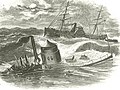 | June 23, 1986 (#74002299) | Cape Hatteras 35°00′06″N 75°24′23″W / 35.001667°N 75.406389°W / 35.001667; -75.406389 (MONITOR) | Dare | USS Monitor shipwreck (ironclad). |
| 24 | Pauli Murray Family Home |  | December 23, 2016 (#100000866) | Durham 35°59′34″N 78°54′59″W / 35.992778°N 78.916389°W / 35.992778; -78.916389 (Pauli Murray Family Home) | Durham | Now the Pauli Murray Center. |
| 25 | Nash-Hooper House |  | November 11, 1971 (#71000610) | Hillsborough 36°04′37″N 79°06′01″W / 36.077058°N 79.100232°W / 36.077058; -79.100232 (Nash-Hooper House) | Orange | NRHP 71000610 |
| 26 | North Carolina Mutual Life Insurance Company Building |  | May 15, 1975 (#75001258) | Durham 35°59′45″N 78°54′03″W / 35.995911°N 78.900857°W / 35.995911; -78.900857 (North Carolina Mutual Life Insurance Company Building) | Durham | 1921 commercial building; second headquarters of a major black-owned insurance company. |
| 27 | NORTH CAROLINA |  | January 14, 1986 (#82004893) | Wilmington 34°14′06″N 77°56′34″W / 34.2349°N 77.942855°W / 34.2349; -77.942855 (NORTH CAROLINA) | New Hanover | NRHP 82004893. USS North Carolina (battleship). |
| 28 | Old East |  | December 21, 1965 (#66000596) | Chapel Hill 35°54′38″N 79°03′03″W / 35.910618°N 79.05075°W / 35.910618; -79.05075 (Old East) | Orange | First building of first state university in the United States, built in 1795 |
| 29 | Old Salem Historic District |  | November 13, 1966 (#66000591) | Winston-Salem 36°05′12″N 80°14′31″W / 36.086624°N 80.2419°W / 36.086624; -80.2419 (Old Salem Historic District) | Forsyth | Early Moravian settlement, now a museum |
| 30 | Palmer-Marsh House |  | April 15, 1970 (#70000439) | Bath 35°28′30″N 76°48′51″W / 35.474870°N 76.814170°W / 35.474870; -76.814170 (Palmer-Marsh House) | Beaufort | |
| 31 | Pinehurst Historic District |  | June 19, 1996 (#73001361) | Pinehurst 35°11′42″N 79°28′23″W / 35.1951°N 79.473164°W / 35.1951; -79.473164 (Pinehurst Historic District) | Moore | Resort community designed by Frederick Law Olmsted; also includes Pinehurst Resort |
| 32 | Playmakers Theatre |  | November 7, 1973 (#71000605) | Chapel Hill 35°54′17″N 79°03′02″W / 35.904754°N 79.050450°W / 35.904754; -79.050450 (Playmakers Theatre) | Orange | Academic building in the Greek Revival style by New York architect Alexander Jackson Davis. |
| 33 | Reed Gold Mine | 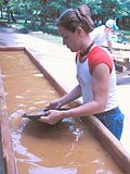 | May 23, 1966 (#66000587) | Concord 35°17′08″N 80°28′12″W / 35.28542°N 80.46996°W / 35.28542; -80.46996 (Reed Gold Mine) | Cabarrus | Site of first gold discovery in United States |
| 34 | Salem Tavern |  | January 29, 1964 (#66000592) | Winston-Salem 36°05′07″N 80°14′30″W / 36.085336°N 80.241745°W / 36.085336; -80.241745 (Salem Tavern) | Forsyth | Vernacular structure erected in the eighteenth century that served as a social center of the North Carolina Piedmont. |
| 35 | Single Brothers' House |  | April 15, 1970 (#70000454) | Winston-Salem 36°05′15″N 80°14′32″W / 36.087560°N 80.242105°W / 36.087560; -80.242105 (Single Brothers' House) | Forsyth | Early vernacular structure that exemplifies the central European architectural traditions of the Moravians. |
| 36 | Town Creek Indian Mound |  | July 19, 1964 (#66000594) | Mount Gilead 35°10′58″N 79°55′46″W / 35.182806°N 79.929472°W / 35.182806; -79.929472 (Town Creek Indian Mound) | Montgomery | Archaeological site |
| 37 | Union Tavern |  | May 15, 1975 (#75001245) | Milton 36°32′12″N 79°12′24″W / 36.536567°N 79.206785°W / 36.536567; -79.206785 (Union Tavern) | Caswell | Early nineteenth century vernacular structure with strong associations with influential freedman cabinetmaker Thomas Day. |
| 38 | Thomas Wolfe House | 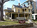 | November 11, 1971 (#71000572) | Asheville 35°35′45″N 82°32′43″W / 35.595699°N 82.545287°W / 35.595699; -82.545287 (Thomas Wolfe House) | Buncombe | |
| 39 | Wright Brothers National Memorial Visitor Center |  | January 3, 2001 (#66000071) | Kill Devil Hills 36°01′14″N 75°40′03″W / 36.020659°N 75.667596°W / 36.020659; -75.667596 (Wright Brothers National Memorial Visitor Center) | Dare |
See also
Wikimedia Commons has media related to National Historic Landmarks in North Carolina.
- National Register of Historic Places listings in North Carolina
- List of National Historic Landmarks by state
References
- ^ Numbers represent an alphabetical ordering by significant words. Various colorings, defined here, differentiate National Historic Landmarks and historic districts from other NRHP buildings, structures, sites or objects.
- ^ The eight-digit number below each date is the number assigned to each location in the National Register Information System database, which can be viewed by clicking the number.
External links
Map all coordinates using OpenStreetMap
Download coordinates as:
- KML
- GPX (all coordinates)
- GPX (primary coordinates)
- GPX (secondary coordinates)
- "National Register Information System". National Register of Historic Places. National Park Service. July 9, 2010.
- v
- t
- e
- Alabama
- Alaska
- Arizona
- Arkansas
- California
- Colorado
- Connecticut
- Delaware
- Florida
- Georgia
- Hawaii
- Idaho
- Illinois
- Indiana
- Iowa
- Kansas
- Kentucky
- Louisiana
- Maine
- Maryland
- Massachusetts
- Michigan
- Minnesota
- Mississippi
- Missouri
- Montana
- Nebraska
- Nevada
- New Hampshire
- New Jersey
- New Mexico
- New York
- North Carolina
- North Dakota
- Ohio
- Oklahoma
- Oregon
- Pennsylvania
- Rhode Island
- South Carolina
- South Dakota
- Tennessee
- Texas
- Utah
- Vermont
- Virginia
- Washington
- West Virginia
- Wisconsin
- Wyoming
| Insular area | |
|---|---|
| Associated state | |
| Foreign country |
| |
|---|---|
| Topics | |
| Lists by state |
|
| Lists by insular areas | |
| Lists by associated state | |
| Other areas | |
| Related | |
| |


