Lendelede
Municipality in Flemish Community, Belgium

Flag

Coat of arms
Location of Lendelede


Lendelede
Location in Belgium 
Location of Lendelede in West-Flanders

 Belgium
 (2019-01-01)[1]
8860
34025
Lendelede (Dutch pronunciation: [ˈlɛndəˌleːdə]; West Flemish: Lendlee) is a municipality located in the Belgian province of West Flanders. The municipality comprises only the town of Lendelede proper. On January 1, 2006, Lendelede had a total population of 5,399. The total area is 13.15 km2 which gives a population density of 411 inhabitants per km2.
People from Lendelede
- Ludovicus Baekelandt [nl]
- Achille Delaere
- Jan Kuyckx
- Noël Dejonckheere
Gallery
-
![Ludovicus Baekelandt [nl], 1774–1803, highwayman](//upload.wikimedia.org/wikipedia/commons/thumb/1/1b/L._Baekelandt.jpg/120px-L._Baekelandt.jpg) Ludovicus Baekelandt [nl], 1774–1803, highwayman
Ludovicus Baekelandt [nl], 1774–1803, highwayman -
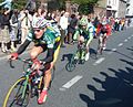 2007 Tour of Flanders through Lendelede with Jan Kuyckx (Landbouwkrediet); Aleksandr Kuschynski (Liquigas); Evert Verbist (- Topsport Vlaanderen)
![Ludovicus Baekelandt [nl], 1774–1803, highwayman](http://upload.wikimedia.org/wikipedia/commons/thumb/1/1b/L._Baekelandt.jpg/120px-L._Baekelandt.jpg)

References
- ^ "Wettelijke Bevolking per gemeente op 1 januari 2018". Statbel. Retrieved 9 March 2019.
External links
 Media related to Lendelede at Wikimedia Commons
- Official website (in Dutch)


- v
- t
- e

- Bold indicates cities
- Italic indicates Municipalities with language facilities
Authority control databases | |
|---|---|
| International |
|
| National |
|
| Geographic |
|
 | This West Flanders location article is a stub. You can help Wikipedia by expanding it. |
- v
- t
- e


