Labessière-Candeil
Commune in Occitania, France

Coat of arms
Location of Labessière-Candeil

(2020–2026) Francis Monsarrat[1]
1
(2021)[2]
81117 /81300
(avg. 265 m or 869 ft)
Labessière-Candeil (French pronunciation: [labesjɛʁ kɑ̃dɛj]; Occitan: La Becièira de Candelh) is a commune in the Tarn department in southern France.
See also
-
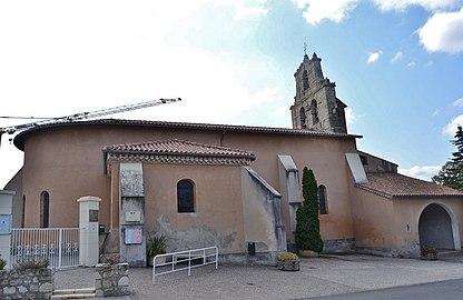 Church Sainte-Anne.
 -
 Shrine as of Labessière-Candeil
 -
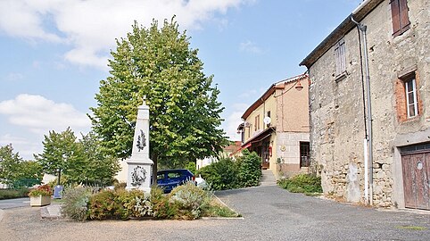 War memorial


References
- ^ "Répertoire national des élus: les maires". data.gouv.fr, Plateforme ouverte des données publiques françaises (in French). 2 December 2020.
- ^ "Populations légales 2021". The National Institute of Statistics and Economic Studies. 28 December 2023.
Wikimedia Commons has media related to Labessière-Candeil.
- v
- t
- e
Communes of the Tarn department
- Aguts
- Aiguefonde
- Alban
- Albipref
- Albine
- Algans
- Almayrac
- Alos
- Amarens
- Ambialet
- Ambres
- Andillac
- Andouque
- Anglès
- Appelle
- Arfons
- Arifat
- Arthès
- Assac
- Aussac
- Aussillon
- Bannières
- Barre
- Beauvais-sur-Tescou
- Belcastel
- Bellegarde-Marsal
- Belleserre
- Berlats
- Bernac
- Bertre
- Le Bez
- Blan
- Blaye-les-Mines
- Boissezon
- Bournazel
- Bout-du-Pont-de-Larn
- Brassac
- Brens
- Briatexte
- Brousse
- Broze
- Burlats
- Busque
- Cabanès
- Les Cabannes
- Cadalen
- Cadix
- Cagnac-les-Mines
- Cahuzac
- Cahuzac-sur-Vère
- Cambon
- Cambon-lès-Lavaur
- Cambounès
- Cambounet-sur-le-Sor
- Les Cammazes
- Campagnac
- Carbes
- Carlus
- Carmaux
- Castanet
- Castelnau-de-Lévis
- Castelnau-de-Montmiral
- Castressubpr
- Caucalières
- Cestayrols
- Combefa
- Cordes-sur-Ciel
- Coufouleux
- Courris
- Crespin
- Crespinet
- Cunac
- Cuq
- Cuq-Toulza
- Curvalle
- Damiatte
- Dénat
- Donnazac
- Dourgne
- Le Dourn
- Durfort
- Escoussens
- Escroux
- Espérausses
- Fauch
- Faussergues
- Fayssac
- Fénols
- Fiac
- Florentin
- Fontrieu
- Fraissines
- Frausseilles
- Le Fraysse
- Fréjairolles
- Fréjeville
- Gaillac
- Garrevaques
- Le Garric
- Garrigues
- Gijounet
- Giroussens
- Graulhet
- Grazac
- Guitalens-L'Albarède
- Itzac
- Jonquières
- Jouqueviel
- Labarthe-Bleys
- Labastide-de-Lévis
- Labastide-Gabausse
- Labastide-Rouairoux
- Labastide-Saint-Georges
- Labessière-Candeil
- Laboulbène
- Laboutarie
- Labruguière
- Lacabarède
- Lacapelle-Pinet
- Lacapelle-Ségalar
- Lacaune
- Lacaze
- Lacougotte-Cadoul
- Lacroisille
- Lacrouzette
- Lagardiolle
- Lagarrigue
- Lagrave
- Lamillarié
- Lamontélarié
- Laparrouquial
- Larroque
- Lasfaillades
- Lasgraisses
- Lautrec
- Lavaur
- Lédas-et-Penthiès
- Lempaut
- Lescout
- Lescure-d'Albigeois
- Lisle-sur-Tarn
- Livers-Cazelles
- Lombers
- Loubers
- Loupiac
- Lugan
- Magrin
- Mailhoc
- Marnaves
- Marssac-sur-Tarn
- Marzens
- Le Masnau-Massuguiès
- Massac-Séran
- Massaguel
- Massals
- Maurens-Scopont
- Mazamet
- Mézens
- Milhars
- Milhavet
- Miolles
- Mirandol-Bourgnounac
- Missècle
- Monestiés
- Montans
- Montauriol
- Montcabrier
- Montdragon
- Montdurausse
- Montels
- Montfa
- Montgaillard
- Montgey
- Montirat
- Montpinier
- Montredon-Labessonnié
- Mont-Roc
- Montrosier
- Montvalen
- Moularès
- Moulayrès
- Moulin-Mage
- Mouzens
- Mouzieys-Panens
- Mouzieys-Teulet
- Murat-sur-Vèbre
- Nages
- Navès
- Noailhac
- Noailles
- Orban
- Padiès
- Palleville
- Pampelonne
- Parisot
- Paulinet
- Payrin-Augmontel
- Péchaudier
- Penne
- Peyregoux
- Peyrole
- Pont-de-Larn
- Poudis
- Poulan-Pouzols
- Prades
- Pratviel
- Puéchoursi
- Puybegon
- Puycalvel
- Puycelsi
- Puygouzon
- Puylaurens
- Rabastens
- Rayssac
- Réalmont
- Le Rialet
- Le Riols
- Rivières
- Roquecourbe
- Roquemaure
- Roquevidal
- Rosières
- Rouairoux
- Rouffiac
- Roussayrolles
- Saint-Affrique-les-Montagnes
- Saint-Agnan
- Saint-Amancet
- Saint-Amans-Soult
- Saint-Amans-Valtoret
- Saint-André
- Saint-Avit
- Saint-Beauzile
- Saint-Benoît-de-Carmaux
- Saint-Christophe
- Saint-Cirgue
- Sainte-Cécile-du-Cayrou
- Sainte-Croix
- Sainte-Gemme
- Saint-Gauzens
- Saint-Genest-de-Contest
- Saint-Germain-des-Prés
- Saint-Germier
- Saint-Grégoire
- Saint-Jean-de-Marcel
- Saint-Jean-de-Rives
- Saint-Jean-de-Vals
- Saint-Juéry
- Saint-Julien-du-Puy
- Saint-Julien-Gaulène
- Saint-Lieux-lès-Lavaur
- Saint-Marcel-Campes
- Saint-Martin-Laguépie
- Saint-Michel-de-Vax
- Saint-Michel-Labadié
- Saint-Paul-Cap-de-Joux
- Saint-Pierre-de-Trivisy
- Saint-Salvi-de-Carcavès
- Saint-Salvy-de-la-Balme
- Saint-Sernin-lès-Lavaur
- Saint-Sulpice-la-Pointe
- Saint-Urcisse
- Saïx
- Saliès
- Salles
- Salvagnac
- Saussenac
- Sauveterre
- La Sauzière-Saint-Jean
- Le Ségur
- Sémalens
- Senaux
- Senouillac
- Le Sequestre
- Sérénac
- Serviès
- Sieurac
- Sorèze
- Soual
- Souel
- Taïx
- Tanus
- Tauriac
- Técou
- Teillet
- Terre-de-Bancalié
- Terssac
- Teulat
- Teyssode
- Tonnac
- Tréban
- Trébas
- Trévien
- Vabre
- Valderiès
- Valdurenque
- Valence-d'Albigeois
- Vaour
- Veilhes
- Vénès
- Verdalle
- Le Verdier
- Viane
- Vielmur-sur-Agout
- Vieux
- Villefranche-d'Albigeois
- Villeneuve-lès-Lavaur
- Villeneuve-sur-Vère
- Vindrac-Alayrac
- Le Vintrou
- Virac
- Viterbe
- Viviers-lès-Lavaur
- Viviers-lès-Montagnes
- pref: prefecture
- subpr: subprefecture
| Authority control databases: National |
|
|---|
 | This Tarn geographical article is a stub. You can help Wikipedia by expanding it. |
- v
- t
- e


