Komárom District
Districts of Hungary in Komárom-Esztergom
Komárom District Komáromi járás | |
|---|---|
Districts of Hungary | |
 Coat of arms | |
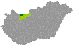 Komárom District within Hungary and Komárom-Esztergom County. | |
| Country |  Hungary Hungary |
| County | Komárom-Esztergom |
| District seat | Komárom |
| Area | |
| • Total | 378.78 km2 (146.25 sq mi) |
| • Rank | 3rd in Komárom-Esztergom |
| Population (2011 census) | |
| • Total | 39,863 |
| • Rank | 3rd in Komárom-Esztergom |
| • Density | 105/km2 (270/sq mi) |
| Website | Official website |
Komárom (Hungarian: Komáromi járás) is a district in north-western part of Komárom-Esztergom County. Komárom is also the name of the town where the district seat is found. The district is located in the Central Transdanubia Statistical Region.
Geography
Komárom District borders with the Slovakian region of Nitra to the north, Tata District to the east, Oroszlány District and Kisbér District to the south, Győr District (Győr-Moson-Sopron County) to the west. The number of the inhabited places in Komárom District is 9.
Municipalities
The district has 3 towns, 1 large village and 5 villages (ordered alphabetically, as of 1 January 2013):[1]
- Ács (6,808)
- Almásfüzitő (2,089)
- Bábolna (3,774)
- Bana (1,630)
- Csém (416)
- Kisigmánd (475)
- Komárom (19,200) – district seat
- Mocsa (2,142)
- Nagyigmánd (3,025)
The bolded municipalities are cities, italics municipality is large village.
Demographics
Religion in Komárom District (2011 census)
Catholic Church (33.8%)
Greek Catholicism (0.4%)
Calvinism (17.6%)
Lutheranism (1.1%)
Other religions (1.1%)
Non-religious (16.3%)
Atheists (1.1%)
Undeclared (28.6%)
In 2011, it had a population of 39,863 and the population density was 105/km2.
| Year | County population[2] | Change |
|---|---|---|
| 2011 | 39,863 | n/a |
Ethnicity
Besides the Hungarian majority, the main minorities are the Roma (approx. 350), German (250) and Slovak (150).
Total population (2011 census): 39,863
Ethnic groups (2011 census):[3]
- Hungarians: 34,121 (96.72%)
- Gypsies: 352 (1.00%)
- Others and indefinable: 806 (2.28%)
- Did not declare their ethnic group: approx. 4,500 persons
Religion
Religious adherence in the county according to 2011 census:[4]
- Catholic – 13,637 (Roman Catholic – 13,489; Greek Catholic – 141);
- Reformed – 7,013;
- Evangelical – 427;
- other religions – 427;
- Non-religious – 6,496;
- Atheism – 441;
- Undeclared – 11,422.
See also
References
External links
- Postal codes of the Komárom District
- v
- t
- e

47°44′00″N 18°07′00″E / 47.7333°N 18.1167°E / 47.7333; 18.1167
 | This Komárom-Esztergom location article is a stub. You can help Wikipedia by expanding it. |
- v
- t
- e


