Kokoda Rural LLG
Local-level government in Papua New Guinea
Place in Oro Province, Papua New Guinea
8°58′41″S 147°52′26″E / 8.978°S 147.874°E / -8.978; 147.874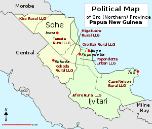
Kokoda Rural LLG is a local-level government (LLG) of Oro Province, Papua New Guinea.[1][2]
Wards
- 01. Asimba
- 02. Kovelo
- 04. Saga
- 06. Iora Lss Blocks
- 07. Kebara
- 08. Abuari
- 09. Alola
- 10. Waju
- 11. Hangiri
- 12. Ambene
- 13. Ilimo
- 14. Hamara
- 15. Ajeka
- 16. Evasusu
- 17. Asisi
- 18. Sairope
- 19. Putembo
- 20. Asafa
- 21. Wora
- 22. Emo
- 23. Awoma
- 24. Kovio
- 81. Kokoda Urban
- 82. Mamba Urban
References
- ^ "Census Figures by Wards - Southern Region". www.nso.gov.pg. 2011 National Population and Housing Census: Ward Population Profile. Port Moresby: National Statistical Office, Papua New Guinea. 2014. Archived from the original on 2019-10-30. Retrieved 2019-10-10.
- ^ "Final Figures". www.nso.gov.pg. 2011 National Population and Housing Census: Ward Population Profile. Port Moresby: National Statistical Office, Papua New Guinea. 2014. Archived from the original on 2015-09-06. Retrieved 2019-10-10.
- OCHA FISS (2018). "Papua New Guinea administrative level 0, 1, 2, and 3 population statistics and gazetteer". Humanitarian Data Exchange. 1.31.9.
- United Nations in Papua New Guinea (2018). "Papua New Guinea Village Coordinates Lookup". Humanitarian Data Exchange. 1.31.9.
- v
- t
- e
- Afore Rural
- Oro Bay Rural
- Popondetta Urban
- Safia Rural
- Tufi Rural (Cape Nelson)

- Higaturu Rural
- Kira Rural
- Kokoda Rural
- Tamata Rural
 | This Oro Province geography article is a stub. You can help Wikipedia by expanding it. |
- v
- t
- e


