Kilspindie
Human settlement in Scotland
- Perth and Kinross
- Perth and Kinross
- North Tayside
- North East Scotland
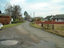
Kilspindie is a village in Perth and Kinross, Scotland.[1] It is situated on the Kilspindie burn, approximately 2+3⁄4 miles (4.5 kilometres) northwest of Errol, 12 miles (19 kilometres) west of Dundee centre and 6+1⁄2 miles (10 kilometres) east of Perth.[2] The village has an area of 6,500 acres (2,600 hectares) of which 3,500 acres (1,400 hectares) are arable land and 200 acres (81 hectares) are woodland, the local geology is mostly whinstone, amygdule and trap.[3] Records show there was a chapel in the village since at least 1214 though the current church, the Kilspindie and Rait Parish Church, was built in 1670 and refurbished in 1938.[4] The village previously housed the Kilspindie Castle which was demolished before 1670.
In the Ordnance Gazetteer of Scotland (1882–84) Francis Groome described Kilspindie:
Kilspindie, a village and a parish in Gowrie district, SE Perthshire. The village, standing in the mouth of a small glen, 1 mile SSW of Rait, 2⅛ miles NNW of Errol station, and 3⅜ NNE of Glencarse station, had anciently a castle, now extinct, and figures in Blind Harry's narrative as the place where Sir William Wallace, with his mother, found refuge in his boyhood.[5]
The village is twinned with Fléac in France.[4]
References
- ^ Ordnance Survey: Landranger map sheet 53 Blairgowrie & Forest of Alyth (Map). Ordnance Survey. 2012. ISBN 9780319231210.
- ^ Google (13 September 2018). "Kilspindie" (Map). Google Maps. Google. Retrieved 13 September 2018.
- ^ Lewis, Samuel (1846). 'Kilmarnock - Kilspindie', in A Topographical Dictionary of Scotland. London. pp. 42–61. Retrieved 13 September 2018.
{{cite book}}:|website=ignored (help) - ^ a b "Kilspindie and Rait Parish Church a Brief History". Clan Cleland.
- ^ "A Vision of Britain Through Time: Kilspindie". www.visionofbritain.co.uk. GB Historical GIS/University of Portsmouth. Retrieved 18 March 2016.
Wikimedia Commons has media related to Kilspindie.
- v
- t
- e
Settlements in Perth and Kinross
- Abernethy
- Abernyte
- Achalader
- Airntully
- Alyth
- Ardler
- Balbeggie
- Bankfoot
- Birnam
- Blairgowrie and Rattray
- Bridge of Cally
- Burrelton
- Campmuir
- Caputh
- Clunie
- Collace
- Cottown
- Craigie
- Coupar Angus
- Dunkeld
- Errol
- Finegand
- Forteviot
- Glencarse
- Harrietfield
- Huntingtower and Ruthvenfield
- Inchture
- Inchyra
- Invergowrie
- Kettins
- Kilspindie
- Kinfauns
- Kingoodie
- Kinloch (Blairgowrie)
- Kinloch (Coupar Angus)
- Kinnaird (Gowrie)
- Kinrossie
- Kirkmichael
- Leetown
- Longforgan
- Luncarty
- Meikleour
- Meigle
- Moneydie
- Murthly
- Perth
- Pitcairngreen
- Pitcur
- Pitmiddle
- Rait
- Redgorton
- Rhynd
- St Madoes
- St Martins
- Scone
- Spittal of Glenshee
- Stanley
- Stormontfield
- Waterloo
- Wolfhill
- Woodside
- Aberargie
- Abercairny
- Aberdalgie
- Aberuthven
- Almondbank
- Ardoch
- Auchterarder
- Balgowan
- Blackford
- Braco
- Bridge of Earn
- Carpow
- Comrie
- Crieff
- Dunning
- Findo Gask
- Forgandenny
- Forteviot
- Fowlis Wester
- Greenloaning
- Invermay
- Madderty
- Methven
- Monzievaird
- Muthill
- Ochtertyre
- Pitkeathly Wells
- St Fillans
- Tibbermore
- Tullibardine
Authority control databases | |
|---|---|
| International |
|
| National |
|
 | This Perth and Kinross location article is a stub. You can help Wikipedia by expanding it. |
- v
- t
- e


