Khirbet Jurish
Archaeological ruin southeast of Jerusalem
31°42′55″N 35°05′1″E / 31.71528°N 35.08361°E / 31.71528; 35.08361Khirbet Jurish (Heb. Hurvat Geres) is an archaeological site 30 kilometres (19 mi) southwest of Jerusalem. At the site that is protected by the Israel Nature and Parks Authority remains of a Jewish village were found, dating to the Second Temple period.[2][3] The ruins of the site stand on a hill to the west of Tzur Hadassa, on a mountain now called Har Kitron, along regional highway 375.[2]
Description
The site, surveyed by archaeologist Boaz Zissu on behalf of the Israel Antiquities Authority, covers an area of about 40 dunams (9.8 acres) and sits at an elevation of 751 metres (2,464 ft) above sea-level. The ruin lay adjacent to the old Jerusalem-Beit Gubrin Roman road,[4] and was visited by PEF explorers, Conder and Kitchener.[5] Three or four miqva'ot have been discovered on the site, attesting to it being an ancient Jewish settlement.[2][3] The site also contains a large bottle-shaped cistern, with a depth of about 6 meters, and a bottom measuring 4.3 x 4.7 meters. Potsherds found on the site have been dated back to the Hellenistic, early Roman, and Byzantine periods.[6] On the western slope of the ruin are five rock-carved sepulchres, attesting to the site's antiquity.
See also
- Gerasa (Judaea)
Gallery
-
 Stone wall at Khirbet Jurish
 -
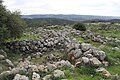 General view of ruins at Kh. Jurish
 -
 Burial chambers, cut in rock at Kh. Jurish
 -
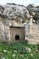 Tomb at Ruin Jurish
 -
 Burial stone used to cover entrance to burial cave
 -
 Burial chambers in Kh. Jurish
 -
 Ruin of Jurish
 -
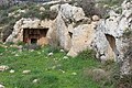
 Cave dwelling
 -
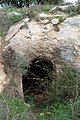
 Cistern at Khirbet Jurish
 -
 Rock-cut tombs
 -
 Burial tombs
 -
 View looking west from Khirbet Jurish


References
- ^ meaning "The ruin of Jurish", according to Palmer, 1881, p. 307
- ^ a b c Zissu, Boaz (2007). "לזיהוי היישוב 'גרסה' ביהודה". מחקרי יהודה ושומרון. 16: 219–228.
- ^ a b "גיליון 125 לשנת 2013חורבת גרס". www.hadashot-esi.org.il. Retrieved 2024-05-22.
- ^ "Elah Roman Road". BibleWalks 500+ sites. Retrieved 2023-08-07.
- ^ Conder and Kitchener (1883), p. 116
- ^ Zissu (2007), p. 221
Bibliography
- Conder, C.R.; Kitchener, H.H. (1883). The Survey of Western Palestine: Memoirs of the Topography, Orography, Hydrography, and Archaeology. Vol. 3. London: Committee of the Palestine Exploration Fund.
- Palmer, E.H. (1881). The Survey of Western Palestine: Arabic and English Name Lists Collected During the Survey by Lieutenants Conder and Kitchener, R. E. Transliterated and Explained by E.H. Palmer. Committee of the Palestine Exploration Fund.
- Zissu, Boaz (2007). Ya'acov Eshel (ed.). "Excavations and Surveys - Identification of Gerasa in Judea". Judea and Samaria Research Studies (in Hebrew). 16. Ariel: 219–231.
External links
- Survey of Western Palestine, Map 17: IAA, Wikimedia commons


