Katwoude
Village in North Holland, Netherlands

Coat of arms
52°28′N 5°3′E / 52.467°N 5.050°E / 52.467; 5.050
 North Holland
 (2021)[1]
1145[1]
Katwoude is a village in the province of North Holland, Netherlands. It is a part of the municipality of Waterland, and lies on the coast of the IJsselmeer, about 2 km north of Monnickendam.
The village was first mentioned in 1310 as "lant van Kattwoude". Even though there is a cat in the shield dating from 1566, it is not related to the animal.[3] The name of the village refers to a swamp forest (-woude) that grew on kattige soil. This refers to the poor, lumpy peat soil around Katwoude.[4]
Katwoude was home to 182 people in 1840. It used to be a separate municipality between 1817 and 1991, when it became part of Waterland.[5] Katwoude used to share a mayor with Monnickendam.[6]
The hamlet Zedde is part of Katwoude.
Gallery
-
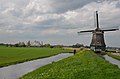 Polder windmill
 -
 Farm in Katwoude
 -
 Monnickendam seen from Katwoude
 -
 Jacobshoeve cheese factory


References
- ^ a b c "Kerncijfers wijken en buurten 2021". Central Bureau of Statistics. Retrieved 2 May 2022.
- ^ "Postcodetool for 1145PK". Actueel Hoogtebestand Nederland (in Dutch). Het Waterschapshuis. Retrieved 2 May 2022.
- ^ "Katwoude - (geografische naam)". Etymologiebank (in Dutch). Retrieved 2 May 2022.
- ^ "Katwoude". www.absolutefacts.com. Retrieved 2023-10-25.
- ^ Ad van der Meer and Onno Boonstra, Repertorium van Nederlandse gemeenten, KNAW, 2011.
- ^ "Katwoude". Plaatsengids (in Dutch). Retrieved 2 May 2022.
- v
- t
- e
Populated places in the municipality of Waterland
- Broek in Waterland
- Ilpendam
- Katwoude
- Marken
- Purmer (partially)
- Uitdam
- Watergang
- Zuiderwoude
 | This North Holland location article is a stub. You can help Wikipedia by expanding it. |
- v
- t
- e


