Jermantown, Virginia
Unincorporated community in Virginia, United States
Unincorporated community in Virginia, United States
38°51′25″N 77°19′56″W / 38.85694°N 77.33222°W / 38.85694; -77.33222Jermantown is an unincorporated community in Fairfax County, Virginia, United States. Various parts of Jermantown are included within the independent city of Fairfax to its south and east. Today, this once rural community is centered at the intersection of Jermantown Road and Lee Jackson Memorial Highway (U.S. Route 50). The Old Jermantown School was located at the present site of Providence Elementary School.[2]
History
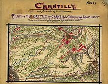
Jermantown/Germantown, located near the critical intersection of the Little River Turnpike (today Route 50) and Warrenton Turnpike (today Route 29), was part of the Ox Hill battlefield on September 1, 1862, and was held by Union troops under General Joseph Hooker.
References
- v
- t
- e
Municipalities and communities of Fairfax County, Virginia, United States
County seat: Fairfax
- Clifton
- Herndon
- Vienna

- Annandale
- Bailey's Crossroads
- Belle Haven
- Braddock
- Bull Run
- Burke
- Burke Centre
- Centreville
- Chantilly
- Crosspointe
- Difficult Run
- Dranesville
- Dunn Loring
- Fair Lakes
- Fair Oaks
- Fairfax Station
- Floris
- Fort Belvoir
- Fort Hunt
- Franconia
- Franklin Farm
- George Mason
- Great Falls
- Great Falls Crossing
- Greenbriar
- Groveton
- Hayfield
- Huntington
- Hutchison
- Hybla Valley
- Idylwood
- Kings Park
- Kings Park West
- Kingstowne
- Lake Barcroft
- Laurel Hill
- Lincolnia
- Long Branch
- Lorton
- Mantua
- Mason Neck
- McLean
- McNair
- Merrifield
- Mount Vernon
- Navy
- Newington
- Newington Forest
- North Springfield
- Oakton
- Pimmit Hills
- Ravensworth
- Reston
- Rose Hill
- Seven Corners
- South Falls Church
- South Run
- Springfield
- Sully Square
- Tysons
- Union Mill
- Wakefield
- West Falls Church
- West Springfield
- Wolf Trap
- Woodburn
- Woodlawn
communities
- Accotink
- Arcturus
- Barkers Crossroads
- Blevinstown
- Browns Mill
- Colchester
- Colchester Hunt
- Cooktown
- Culmore
- Doveville
- Farrs Corner
- Five Forks
- Gum Springs
- Hattontown
- Hollin Hills
- Hollindale
- Jermantown
- Langley
- Lewinsville
- Lewis Park
- New Alexandria
- Oak Hill
- Odricks Corner
- Pohick
- Rainbow
- Shady Oak
- Sleepy Hollow
- South Alexandria
- Uniontown
- Westhampton
- West McLean
- Virginia portal
- United States portal
 | This Fairfax County, Virginia state location article is a stub. You can help Wikipedia by expanding it. |
- v
- t
- e


