Indori fort
18°44′09.8″N 73°42′50.7″E / 18.736056°N 73.714083°E / 18.736056; 73.714083
 Maratha Confederacy (1720–1818)
 United Kingdom
 East India Company (1818–1857)
 British Raj (1857–1947)


 India (1947-)
the public
Indori fort also known as Induri Fort (Marathi: इन्दुरी किल्ला)is one of the many Land forts of Maharashtra state in India. Situated close to the hill station Lonavala and 35 km (22 mi) north of Pune, Indori fort rises to an elevation of 1,033 m (3,389 ft) above sea level. The fort is located on the banks of Indrayani river.[1] The fort was under the Maratha empire for the majority of the time.
History
Indori fort was built by Sarsenapati Khandojirao Yesajirao Dabhade in the year 1720–21.[2] The fort also has a mint building inside the fort which is in a dilapidated state. The widow of Khanderao (Khandojirao), Sarsenapati Umabai Dabhade, was the first and only woman to become Commander-in-Chief of the Maratha forces in 1732. Their daughter Savitribai Dabhade married Srimant Yeshwantrao Mande (Sardar or equivalent of Earl), a descendent of Moropant Trimbak Pingle, the first Peshwa of the Maratha Empire, serving on Shivaji Maharaj's Ashta Pradhan (Council of Eight Ministers).
Induri Fort is also famous as the 'Sarsenapati Dabhade Gaadi' (seat of power) at Induri in 1720–21. The Samadhi of Sarsenapati Khanderao Dabhade is situated at the Shrimant Sarsenapati Dabhade Baneshwar Mandir in Talegaon Dabhade. The current Srimant is Abhishek Mande Bhot, who ascended upon the 'Gaadi' in 1990 upon turning 15.
Accessibility
Indori fort can be accessed by various modes of travel. The nearest railway station is the Ghorawadi 4 km and Talegaon Dabhade railway station which is 4.8 km from Indori Fort are easily accessed by suburban trains between Lonavala and Pune. The nearest major train station is Lonavala, on the Mumbai-Pune railway line. Indori is connected by the Mumbai-Pune Highway and can also be accessed from Talegaon Dabhade (PIN -410506) town.
Places to see
The fort is close to the village Indori. The entrance gate is in good condition. The fort has 9 bastions which are well connected by fortification wall. The walls of the fort are 30–40 feet high made of basalt rock with brick work at the top. There is a temple of Kadjai inside the fort.[3]

Gallery
-

-

-
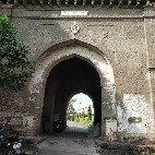 Entrance gate
 -
 Kadjai temple inside the fort


See also
References
- ^ Choudhary, K.K. (15 June 1991). Gazetteers of Bombay Presidency, Poona District. Bombay: Government of Maharashtra. p. Places. Retrieved 16 December 2019.
- ^ Rajadhyaksha, Abhijit. "Modern India". www.historyfiles.co.uk. Retrieved 3 May 2020.
- ^ Trekshitiz. "Induri Fort". www.trekshitiz.com. Trekshitiz. Retrieved 16 December 2019.
External links
- v
- t
- e
Forts in Maharashtra
- Ahmednagar Fort
- Bahadurgad
- Bhairavgad
- Bitangad
- Harishchandragad
- Kaladgad
- Kharda
- Kunjargad
- Madan Fort
- Manjarsumbha fort
- Pabargad
- Patta Fort
- Ratangad
- Amner Fort
- Gawilghur
- Chandrapur Fort
- Ballarpur Fort
- Bhadravati Fort
- Manikgad
- Aavandhagad
- Achala Fort
- Ahivant Fort
- Alang
- Anjaneri
- Ankai Fort
- Bahulagad
- Bhaskargad
- Chandwad
- Chauler Fort
- Dermal
- Dhodap
- Hargad
- Harihar fort
- Hatgad
- Indrai
- Kanchangad
- Kanhergad
- Kavnai fort
- Kulang
- Madangad
- Malegaon
- Mangi-Tungi
- Moragad
- Mulher
- Nhavigad
- Rajdher fort
- Ramsej
- Salher
- Salota
- Saptashrungi
- Tankai fort
- Tringalwadi
- Waghera
- Anghaai Fort
- Bhorgiri Fort
- Chawand
- Dhakoba
- Ghangad
- Hadsar Fort
- Induri Fort
- Jivdhan
- Kailasgad
- Kawla
- Korigad/Koraigad
- Lohagad
- Malhargad
- Manaranjan
- Mangalgad
- Morgiri Fort
- Narayangad
- Nimgiri
- Purandar
- Rajgad
- Rajmachi
- Rayri Fort
- Rohida
- Sangram Durg
- Sindola Fort
- Shaniwar Wada
- Shivneri
- Shrivardhan
- Sinhagad
- Tikona
- Torna
- Tung
- Vajragad Fort
- Visapur
- Agarkot
- Avchitgad
- Bhimashankar Fort
- Birwadi
- Chambhargad
- Chandragad
- Dhak Bahiri
- Dronagiri
- Gadad Bahiri
- Ghangad
- Ghosalgad
- Irshalgad
- Karnala
- Khaderi
- Khanderi
- Kondhawi Fort
- Korlai
- Kothaligad Peb fort
- Kulaba
- Kurdugad
- Lingana
- Maangad
- Madgad
- Malanggad
- Mangalgad (Kangori)
- Manikgad
- Mirgad
- Mrugagad
- Murud-Janjira
- Padargad
- Padmadurg/ Kasa Fort
- Prabalgad
- Raigad
- Ratnagad
- Revdanda
- Sagargad
- Samrajgad
- Sankshi Fort
- Sarasgad
- Sarjekot
- Songad
- Songiri Fort
- Sudhagad
- Surgad
- Talagad
- Underi
- Vikatgad Peb fort
- Aambolgad
- Anjanwel
- Bankot
- Gowalkot
- Jaigad
- Kanakdurg
- Mahipatgad
- Mandangad
- Prachitgad
- Prunagad
- Rasalgad
- Ratnagiri (Ratnadurg)
- Sumargad
- Suvarnadurg
- Yashwantgad
- Ajinkyatara
- Bhairavgad
- Bhushangad
- Chandan-Vandan
- Dategad
- Gunavantgad
- Jangali Jayagad
- Kalyangad
- Kamalgad
- Kenjalgad
- Mahimangad
- Pandavgad
- Prachitgad
- Pratapgad
- Sajjangad
- Santoshgad
- Vairatgad
- Vardhangad
- Varugad
- Vasantgad
- Vasota
- Aasavgad
- Bharatgad
- Rajkot Fort
- Sanrjekot
- Sindhudurg
- Vijaydurg
- Aasawa
- Arnala
- Asherigad
- Ballalgad
- Balwantgad
- Belapur Fort
- Bhairavgad
- Bhandargad
- Bhavanigad
- Bhupatgad
- Chanderigad
- Dahanugad
- Daulatmandal
- Dharavi
- Durgadi Fort
- Gambhirgad
- Ghodbunder Fort
- Gorakhgad
- Gotara
- Jivdhaanigad
- Kamandurg
- Kelwegad
- Kohojgad
- Mahuli
- Malang gad
- Palasgad
- Pankot
- Tahuli
- Shirgav Fort
- Jalna Fort(Mastgarh)
- Rohilagarh
- Jafrabad Qila
| |
|---|---|
| Chhatrapatis | |
| Peshwas | |
| Amatya & Pratinidhi | |
| Women | |
| Maratha Confederacy | |
| Battles |
|
| Wars | |
| Adversaries | |
| Forts | |
| Coins | |


