Hverfjall
Volcano in northern Iceland
Hverfjall (Icelandic pronunciation: [ˈkʰvɛrˌfjatl̥] ⓘ; also known as Hverfell [ˈkʰvɛrˌfɛtl̥]) is a tephra cone or tuff ring volcano in northern Iceland, to the east of Mývatn.
It erupted in 2500 BP in the southern part of the Krafla fissure swarm.[1] The crater is approximately 1 km in diameter.[2]
Tephra has been carried from Hverfjall all over the Mývatn area. A landslide apparently occurred in the south part of the crater during the eruption, which accounts for the disruption to the round shape of the mountain.[citation needed] During the Age of Settlement, lava flowed from Svörtuborgir [ˈsvœr̥tʏˌpɔrcɪr̥], at the southern end of Námafjall [ˈnauːmaˌfjatl̥], around Hverfjall, which was nearly engulfed by the lava. At the same time an eruption occurred in the slopes above the valley of Hlíðardalur [ˈl̥iːðarˌtaːlʏr̥].[citation needed]
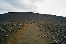
The rim of the crater is only accessible by two paths, from the northwest and south. It is strictly forbidden to use other routes in ascent or descent.
See also
- Volcanism of Iceland
References

External links
![]() Media related to Hverfjall at Wikimedia Commons
Media related to Hverfjall at Wikimedia Commons
Authority control databases | |
|---|---|
| International |
|
| Geographic |
|
- v
- t
- e


