Helliar Holm
Uninhabited tidal island off the coast of Shapinsay in the Orkney Islands, Scotland
59°01′23″N 2°54′04″W / 59.023°N 2.901°W / 59.023; -2.901


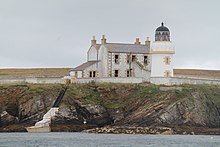
Saeva Ness lighthouse at the southern end of Helliar Holm
red: 10 nautical miles (19 km; 12 mi) [1]
Helliar Holm is an uninhabited island off the coast of Shapinsay in the Orkney Islands, Scotland. It is home to a 42-foot-tall (13 m) lighthouse, which was built in 1893 and automated in 1967.[3] It is a tidal island that used to be connected to Shapinsay. It is still possible to walk across from the mainland during very low tides.
The island also has the ruins of a broch, cairn and chapel.[4]
In the Orkneyinga Saga it is referred to as both "Hellisey" and "Eller Holm" [5] and John of Fordun refers to it as "Helene-holm"
Gallery
-
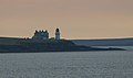 Saeva Ness lighthouse on the tip of Helliar Holm
 -
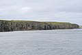 Cliffs and chambered cairn on Helliar Holm.


See also
 Scotland portal
 Engineering portal


References
- ^ Helliar Holm Light Lighthouses Explorer. Retrieved 27 May 2016
- ^ Rowlett, Russ. "Lighthouses of Scotland: Orkney". The Lighthouse Directory. University of North Carolina at Chapel Hill. Retrieved 27 May 2016.
- ^ "Lighthouse Explorer database". Archived from the original on 13 February 2006. Retrieved 14 August 2007.
- ^ Haswell-Smith, Hamish. (2004) The Scottish Islands. Edinburgh. Canongate.
- ^ Anderson, Joseph (Ed.) (1893) Orkneyinga Saga. Translated by Jón A. Hjaltalin & Gilbert Goudie. Edinburgh. James Thin and Mercat Press (1990 reprint). ISBN 0-901824-25-9
External links
- Northern Lighthouse Board
Wikimedia Commons has media related to Helliar Holm.
59°01′23″N 02°54′05″W / 59.02306°N 2.90139°W / 59.02306; -2.90139
- v
- t
- e
North East Orkney Islands
| Authority control databases: Helliar Holm Lighthouse |
|
|---|
 | This Orkney location article is a stub. You can help Wikipedia by expanding it. |
- v
- t
- e
 | This British lighthouse-related article is a stub. You can help Wikipedia by expanding it. |
- v
- t
- e


