Hegyvidék
You can help expand this article with text translated from the corresponding article in Hungarian. (December 2009) Click [show] for important translation instructions.
- View a machine-translated version of the Hungarian article.
- Machine translation, like DeepL or Google Translate, is a useful starting point for translations, but translators must revise errors as necessary and confirm that the translation is accurate, rather than simply copy-pasting machine-translated text into the English Wikipedia.
- Consider adding a topic to this template: there are already 594 articles in the main category, and specifying
|topic=will aid in categorization. - Do not translate text that appears unreliable or low-quality. If possible, verify the text with references provided in the foreign-language article.
- You must provide copyright attribution in the edit summary accompanying your translation by providing an interlanguage link to the source of your translation. A model attribution edit summary is
Content in this edit is translated from the existing Hungarian Wikipedia article at [[:hu:Budapest XII. kerülete]]; see its history for attribution. - You may also add the template
{{Translated|hu|Budapest XII. kerülete}}to the talk page. - For more guidance, see Wikipedia:Translation.
District of Budapest in Central Hungary, Hungary
12th District of Budapest Budapest XII. kerülete Hegyvidék | |
|---|---|
| District XII | |
 Flag  Coat of arms | |
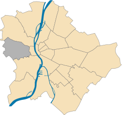 Location of District XII in Budapest (shown in grey) | |
| Coordinates: 47°30′N 19°00′E / 47.5°N 19°E / 47.5; 19 | |
| Country | Hungary |
| Region | Central Hungary |
| City | Budapest |
| Established | 1 July 1940 |
| Quarters[1] | List
|
| Government | |
| • Mayor | Zoltán Pokorni (Fidesz-KDNP) |
| Area | |
| • Total | 26.67 km2 (10.30 sq mi) |
| • Rank | 11th |
| Population (2016)[2] | |
| • Total | 58,171 |
| • Rank | 17th |
| • Density | 2,181/km2 (5,650/sq mi) |
| Demonym | tizenkettedik kerületi ("12th districter") |
| Time zone | UTC+1 (CET) |
| • Summer (DST) | UTC+2 (CEST) |
| Postal code | 1121 ... 1126 |
| Website | www |

Hegyvidék (German: Bergland, literally "Highlands", or "Mountain-land") is the official name of the XII district of Budapest (Hungarian: Budapest XII. kerülete), capital of Hungary. It is a region of Buda, on the west bank of river Danube.
Geography

Being the only district in Buda which has not got a connection to the river Danube, it lies on the green, hilly suburban area of Budapest. It borders 2nd district to the north, the 1st district (Castle district and Gellérthegy) to the east and 11th district (Kelenföld and Sashegy) to the south. Its western border marks the border of the whole city as well. Hegyvidék is said to be the lung of Budapest, as it gives place to many of the untouched green forests of the city and it also houses the highest hill of the entire urban area, János Hill (527 m above sea level).
Neighbourhoods
The district lies on 26.7 square kilometers and has around 75 thousand inhabitants. It has several neighbourhoods: Budakeszierdő, Csillebérc, Farkasrét, Farkasvölgy, Istenhegy, János Hill, Kissvábhegy, Krisztinaváros, Kútvölgy, Magasút, Mártonhegy, Németvölgy, Orbánhegy, Sashegy, Svábhegy, Széchenyihegy, Virányos, Zugliget.
List of mayors
| Member | Party | Date | |
|---|---|---|---|
| Gábor Sebes | SZDSZ | 1990–1994 | |
| István Udvardy-Nagy | MDF | 1994–1998 | |
| György Mitnyan | Fidesz | 1998–2006 | |
| Zoltán Pokorni | Fidesz | 2006– | |
Twin towns
Hegyvidék is twinned with:


Gallery

See also
References
- ^ "94/2012. (XII. 27.) Főv. Kgy. rendelet - a közterület- és városrésznevek megállapításáról, azok jelöléséről, valamint a házszám-megállapítás szabályairól" (in Hungarian).
- ^ a b "A fővárosi kerületek, a megyei jogú városok, a városok területe, lakónépessége és a lakások száma" [The area of districts of the capital, of the towns with county's rights, resident population and number of dwellings]. Magyarország közigazgatási helynévkönyve 2016. január 1 [Gazetteer of Hungary 1st January, 2016] (PDF). Hungarian Central Statistical Office. 2016. p. 21.
External links
Wikivoyage has a travel guide for Hegyvidék.
- Official Homepage (In Hungarian)
- Hegyvidék.hu
- Aerial photographs of Hegyvidék
- v
- t
- e

- I. Várkerület
- II. 2nd district
- III. Óbuda-Békásmegyer
- IV. Újpest
- V. Belváros-Lipótváros
- VI. Terézváros
- VII. Erzsébetváros
- VIII. Józsefváros
- IX. Ferencváros
- X. Kőbánya
- XI. Újbuda
- XII. Hegyvidék
- XIII. 13th district
- XIV. Zugló
- XV. 15th district
- XVI. 16th district
- XVII. Rákosmente
- XVIII. Pestszentlőrinc-Pestszentimre
- XIX. Kispest
- XX. Pesterzsébet
- XXI. Csepel
- XXII. Budafok-Tétény
- XXIII. Soroksár
traditions
- Budapest Business School
- Budapest University of Technology
- Corvinus University
- Eötvös Loránd University
- Hungarian University of Fine Arts
- Liszt Ferenc Academy of Music
- Moholy-Nagy University of Art and Design
- National University of Public Service
- Óbuda University
- Semmelweis University
- University of Physical Education
- Academy of Drama and Film
- Andrássy University
- Aquincum Institute of Technology
- Budapest Metropolitan University
- Budapest University of Jewish Studies
- Central European University
- International Business School
- Károli Gáspár University of Reformed Church
- Pázmány Péter Catholic University
 History of Budapest
 Category


| ||
|---|---|---|
|  | |
| Authority control databases |
|
|---|
 | This Budapest location article is a stub. You can help Wikipedia by expanding it. |
- v
- t
- e


