Hajdúhadház
Town in Hajdú-Bihar, Hungary

Coat of arms
 Hungary
 (2015)
4242
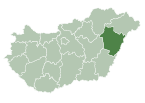
Hajdúhadház is a town in Hajdú-Bihar county, in the Northern Great Plain region of eastern Hungary.
Geography

It covers an area of 87.81 km2 (34 sq mi) and has a population of 12,724 people (2015).[1]
Twin towns – sister cities
Hajdúhadház is twinned with:[2]
 Łęczna, Poland (1996)

References
- ^ a b Gazetteer of Hungary, 1 January 2015. Hungarian Central Statistical Office. 3 September 2015
- ^ "Látnivalók". hajduhadhaz.hu (in Hungarian). Hajdúhadház. Retrieved 9 April 2021.
External links
Wikimedia Commons has media related to Hajdúhadház.
- Official website in Hungarian

| ||
|---|---|---|
| City with county rights |
|   |
| Towns | ||
| Large villages | ||
| Villages |
| |
| Other topics |
| |
47°41′N 21°40′E / 47.683°N 21.667°E / 47.683; 21.667
Authority control databases | |
|---|---|
| International |
|
| National |
|
 | This Hajdú-Bihar location article is a stub. You can help Wikipedia by expanding it. |
- v
- t
- e


