HX postcode area
Postcode area within the United Kingdom
53°43′12″N 1°53′46″W / 53.720°N 1.896°W / 53.720; -1.896
HX
Halifax
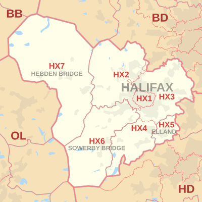
The HX postcode area, also known as the Halifax postcode area,[2] is a group of seven postcode districts in England, within four post towns. These cover most of the Metropolitan Borough of Calderdale in western West Yorkshire, including Halifax, Elland, Sowerby Bridge and Hebden Bridge.
Coverage
The approximate coverage of the postcode districts:
| Postcode district | Post town | Coverage | Local authority area(s) |
|---|---|---|---|
| HX1 | HALIFAX | Halifax Town Centre, Savile Park | Calderdale |
| HX2 | HALIFAX | Highroad Well, Illingworth, Luddenden, Luddenden Foot, Midgley, Mixenden, Mount Tabor, Norton Tower, Ogden, Wainstalls, Warley Town | Calderdale |
| HX3 | HALIFAX | Akroydon, Boothtown, Copley, Hipperholme, Lightcliffe, Northowram, Norwood Green, Ovenden, Shelf, Shibden, Skircoat Green, Southowram | Calderdale |
| HX4 | HALIFAX | Barkisland, Greetland, Holywell Green, Sowood, Stainland, West Vale | Calderdale |
| HX5 | ELLAND | Elland, Blackley | Calderdale |
| HX6 | SOWERBY BRIDGE | Norland, Ripponden, Rishworth, Sowerby, Sowerby Bridge | Calderdale |
| HX7 | HEBDEN BRIDGE | Cragg Vale, Hebden Bridge, Heptonstall, Mytholmroyd, Old Town | Calderdale |
Map
KML file (edit • help)
Template:Attached KML/HX postcode area
KML is from Wikidata
See also
References
- ^ "ONS Postcode Directory Version Notes" (ZIP). National Statistics Postcode Products. Office for National Statistics. May 2020. Table 2. Retrieved 19 June 2020. Coordinates from mean of unit postcode points, "Code-Point Open". OS OpenData. Ordnance Survey. February 2012. Retrieved 21 April 2012.
- ^ Royal Mail, Address Management Guide, (2004)
External links
- Royal Mail's Postcode Address File
- A quick introduction to Royal Mail's Postcode Address File (PAF)
- v
- t
- e
- AB
- AL
- B
- BA
- BB
- BD
- BH
- BL
- BN
- BR
- BS
- BT
- CA
- CB
- CF
- CH
- CM
- CO
- CR
- CT
- CV
- CW
- DA
- DD
- DE
- DG
- DH
- DL
- DN
- DT
- DY
- E
- EC
- EH
- EN
- EX
- FK
- FY
- G
- GL
- GU
- HA
- HD
- HG
- HP
- HR
- HS
- HU
- HX
- IG
- IP
- IV
- KA
- KT
- KW
- KY
- L
- LA
- LD
- LE
- LL
- LN
- LS
- LU
- M
- ME
- MK
- ML
- N
- NE
- NG
- NN
- NP
- NR
- NW
- OL
- OX
- PA
- PE
- PH
- PL
- PO
- PR
- RG
- RH
- RM
- S
- SA
- SE
- SG
- SK
- SL
- SM
- SN
- SO
- SP
- SR
- SS
- ST
- SW
- SY
- TA
- TD
- TF
- TN
- TQ
- TR
- TS
- TW
- UB
- W
- WA
- WC
- WD
- WF
- WN
- WR
- WS
- WV
- YO
- ZE
- Related UK lists: Postcode districts
- Post towns
- Postal counties
- London postal district


