Grade I listed buildings in the City of London
Map all coordinates using OpenStreetMap
Download coordinates as:
- KML
- GPX (all coordinates)
- GPX (primary coordinates)
- GPX (secondary coordinates)
There are over 9,000 Grade I listed buildings in England. This page is a list of these buildings in the City of London.
Buildings
Churches
| Name | Location | Type | Completed [note 1] | Date designated | Grid ref.[note 2] Geo-coordinates | Entry number [note 3] | Image |
|---|---|---|---|---|---|---|---|
| St Paul's Cathedral | Castle Baynard | Cathedral | The previous building Medieval. The present building 1711[1] | 4 January 1950 | TQ3204281141 51°30′50″N 0°05′55″W / 51.513771°N 0.098523°W / 51.513771; -0.098523 (St Paul's Cathedral) | 1079157 | 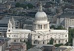 More images |
| Christ Church Greyfriars | Farringdon Within | Church | 1677–91 | 4 January 1950 | TQ3198181372 51°30′57″N 0°05′58″W / 51.515861°N 0.099315°W / 51.515861; -0.099315 (Christ Church Greyfriars) | 1359217 | 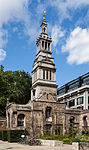 More images |
| Church of All Hallows-on-the-Wall | Broad Street | Church | 1765-7 | 4 January 1950 | TQ3302281485 51°31′00″N 0°05′03″W / 51.516633°N 0.084279°W / 51.516633; -0.084279 (Church of All Hallows-on-the-Wall) | 1064632 |  More images |
| Church of All Hallows by the Tower | Tower | Church | 15th century | 4 January 1950 | TQ3338580687 51°30′34″N 0°04′46″W / 51.509376°N 0.079352°W / 51.509376; -0.079352 (Church of All Hallows by the Tower) | 1064671 |  More images |
| Church of St Andrew | Farringdon Without | Church | 15th century | 4 January 1950 | TQ3147081518 51°31′02″N 0°06′24″W / 51.517293°N 0.106621°W / 51.517293; -0.106621 (Church of St Andrew) | 1064643 |  More images |
| Church of St Andrew by the Wardrobe | Castle Baynard | Church | 1685–95 | 4 January 1950 | TQ3185580980 51°30′45″N 0°06′05″W / 51.512368°N 0.101277°W / 51.512368; -0.101277 (Church of St Andrew by the Wardrobe) | 1079148 |  More images |
| Church of St Andrew Undershaft | Aldgate | Church | 15th century | 4 January 1950 | TQ3325281173 51°30′50″N 0°04′52″W / 51.513775°N 0.081084°W / 51.513775; -0.081084 (Church of St Andrew Undershaft) | 1079155 |  More images |
| Church of St Anne and St Agnes | Aldersgate | Church | Medieval | 4 January 1950 | TQ3218781449 51°30′59″N 0°05′47″W / 51.516505°N 0.09632°W / 51.516505; -0.09632 (Church of St Anne and St Agnes) | 1286384 |  More images |
| Church of St Bartholomew the Great | Farringdon Within | Church | 12th century | 4 January 1950 | TQ3195681711 51°31′08″N 0°05′58″W / 51.518914°N 0.099549°W / 51.518914; -0.099549 (Church of St Bartholomew the Great) | 1180873 |  More images |
| Church of St Benet, Paul's Wharf | Queenhithe | Church | 1677–85 | 4 January 1950 | TQ3200080907 51°30′42″N 0°05′57″W / 51.511678°N 0.099216°W / 51.511678; -0.099216 (Church of St Benet, Paul's Wharf) | 1180700 |  More images |
| Church of St Botolph | Aldersgate | Church | Medieval | 4 January 1950 | TQ3212381501 51°31′01″N 0°05′50″W / 51.516988°N 0.097222°W / 51.516988; -0.097222 (Church of St Botolph) | 1064732 |  More images |
| Church of St Botolph | Portsoken | Church | 1741-4 | 4 January 1950 | TQ3357581215 51°30′51″N 0°04′35″W / 51.514076°N 0.076416°W / 51.514076; -0.076416 (Church of St Botolph) | 1359143 |  More images |
| Church of St Bride | City and County of the City of London | Church | 1670–1684 | 4 January 1950 | TQ3155681128 51°30′50″N 0°06′20″W / 51.513768°N 0.105528°W / 51.513768; -0.105528 (Church of St Bride) | 1064657 |  More images |
| Church of St Clement | City and County of the City of London | Church | 1683-7 | 4 January 1950 | TQ3286480895 51°30′41″N 0°05′12″W / 51.511368°N 0.086777°W / 51.511368; -0.086777 (Church of St Clement) | 1064699 |  More images |
| Church of St Dunstan in the East | City and County of the City of London | Gate | 1698 | 4 January 1950 | TQ3314980718 51°30′35″N 0°04′58″W / 51.509711°N 0.082739°W / 51.509711; -0.082739 (Church of St Dunstan in the East) | 1359173 |  More images |
| Church of St Dunstan-in-the-West (including attached Sunday School) | City and County of the City of London | Statue | 1586 | 4 January 1950 | TQ3122981172 51°30′51″N 0°06′37″W / 51.514239°N 0.110221°W / 51.514239; -0.110221 (Church of St Dunstan-in-the-West (including attached Sunday School)) | 1064663 | 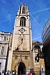 More images |
| Church of St Edmund | City and County of the City of London | Church | 1670-9 | 4 January 1950 | TQ3289581020 51°30′45″N 0°05′11″W / 51.512484°N 0.086284°W / 51.512484; -0.086284 (Church of St Edmund) | 1064631 |  More images |
| Church of St Giles | City and County of the City of London | Church | Mid 16th century | 4 January 1950 | TQ3235181699 51°31′07″N 0°05′38″W / 51.518714°N 0.093864°W / 51.518714; -0.093864 (Church of St Giles) | 1359183 |  More images |
| Church of St Helen | City and County of the City of London | Church | 13th century | 4 January 1950 | TQ3320481285 51°30′53″N 0°04′54″W / 51.514793°N 0.081733°W / 51.514793; -0.081733 (Church of St Helen) | 1286458 |  More images |
| Church of St James Garlickhithe | City and County of the City of London | Church | 1674–87 | 4 January 1950 | TQ3238480854 51°30′40″N 0°05′37″W / 51.511112°N 0.093705°W / 51.511112; -0.093705 (Church of St James Garlickhithe) | 1064669 | 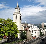 More images |
| Church of St Katherine Cree | City and County of the City of London | Church | Late 18th – Early 19th century | 4 January 1950 | TQ3339781140 51°30′48″N 0°04′44″W / 51.513444°N 0.079008°W / 51.513444; -0.079008 (Church of St Katherine Cree) | 1064627 |  More images |
| Church of St Lawrence Jewry | City and County of the City of London | Church | 1670–86 | 4 January 1950 | TQ3245881325 51°30′55″N 0°05′33″W / 51.515328°N 0.092463°W / 51.515328; -0.092463 (Church of St Lawrence Jewry) | 1064673 |  More images |
| Church of St Magnus the Martyr | City and County of the City of London | Church | 1671–87 | 4 January 1950 | TQ3291080671 51°30′34″N 0°05′10″W / 51.509344°N 0.086199°W / 51.509344; -0.086199 (Church of St Magnus the Martyr) | 1064601 |  More images |
| Church of St Margaret | City and County of the City of London | Church | 1686–95 | 4 January 1950 | TQ3271281280 51°30′54″N 0°05′20″W / 51.514864°N 0.088821°W / 51.514864; -0.088821 (Church of St Margaret) | 1064634 |  More images |
| Church of St Margaret Pattens | City and County of the City of London | Church | 1684-9 | 4 January 1950 | TQ3313080840 51°30′39″N 0°04′59″W / 51.510811°N 0.082967°W / 51.510811; -0.082967 (Church of St Margaret Pattens) | 1286593 | 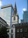 More images |
| Church of St Martin | City and County of the City of London | Church | 1677–87 | 4 January 1950 | TQ3180281172 51°30′51″N 0°06′07″W / 51.514106°N 0.101968°W / 51.514106; -0.101968 (Church of St Martin) | 1359194 |  More images |
| Church of St Mary | City and County of the City of London | Church | 1681–87 | 4 January 1950 | TQ3275580927 51°30′42″N 0°05′18″W / 51.511681°N 0.088335°W / 51.511681; -0.088335 (Church of St Mary) | 1359119 |  More images |
| Church of St Mary-at-Hill | City and County of the City of London | Church | 1670-6 | 4 January 1950 | TQ3308080760 51°30′36″N 0°05′01″W / 51.510104°N 0.083717°W / 51.510104; -0.083717 (Church of St Mary-at-Hill) | 1064600 | 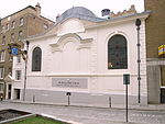 More images |
| Church of St Mary Aldermary | City and County of the City of London | Church | Early 16th century | 4 January 1950 | TQ3240981035 51°30′46″N 0°05′36″W / 51.512733°N 0.093277°W / 51.512733; -0.093277 (Church of St Mary Aldermary) | 1079145 |  More images |
| Church of St Mary Le Bow | City and County of the City of London | Church | 1670–1683 | 4 January 1950 | TQ3238681143 51°30′49″N 0°05′37″W / 51.513709°N 0.093568°W / 51.513709; -0.093568 (Church of St Mary Le Bow) | 1064696 |  More images |
| Church of St Mary Woolnoth | City and County of the City of London | Church | 1716–27 | 4 January 1950 | TQ3277181047 51°30′46″N 0°05′17″W / 51.512756°N 0.088059°W / 51.512756; -0.088059 (Church of St Mary Woolnoth) | 1064620 |  More images |
| Church of St Michael | City and County of the City of London | Church | 1670-7 | 4 January 1950 | TQ3295181101 51°30′48″N 0°05′08″W / 51.513199°N 0.085447°W / 51.513199; -0.085447 (Church of St Michael) | 1286688 |  More images |
| Church of St Michael Paternoster Royal | City and County of the City of London | Church | 1686–94 | 4 January 1950 | TQ3249380866 51°30′40″N 0°05′32″W / 51.511195°N 0.092131°W / 51.511195; -0.092131 (Church of St Michael Paternoster Royal) | 1286707 |  More images |
| Church of St Nicholas Cole Abbey | Bread Street | Church | 1671–81 | 4 January 1950 | TQ3216180959 51°30′44″N 0°05′49″W / 51.512108°N 0.096878°W / 51.512108; -0.096878 (Church of St Nicholas Cole Abbey) | 1079146 |  More images |
| Church of St Olave | Tower | Church | Late 13th century | 4 January 1950 | TQ3337280859 51°30′39″N 0°04′46″W / 51.510925°N 0.079475°W / 51.510925; -0.079475 (Church of St Olave) | 1064676 |  More images |
| Church of St Peter | Cornhill | Church | Medieval | 4 January 1950 | TQ3301081108 51°30′48″N 0°05′05″W / 51.513248°N 0.084594°W / 51.513248; -0.084594 (Church of St Peter) | 1192245 |  More images |
| Church of St Sepulchre | Farringdon Without | Church | Mid 15th century | 4 January 1950 | TQ3177581459 51°31′00″N 0°06′08″W / 51.516691°N 0.10225°W / 51.516691; -0.10225 (Church of St Sepulchre) | 1064640 |  More images |
| Church of St Stephen | Walbrook | Church | 1672–87 | 4 January 1950 | TQ3264681030 51°30′45″N 0°05′24″W / 51.512632°N 0.089866°W / 51.512632; -0.089866 (Church of St Stephen) | 1285320 |  More images |
| Church of St Vedast | City and County of the City of London | Church | 1670-3 | 4 January 1950 | TQ3220281272 51°30′54″N 0°05′46″W / 51.514911°N 0.09617°W / 51.514911; -0.09617 (Church of St Vedast) | 1064666 |  More images |
| Guild Church of St Ethelburga the Virgin | City and County of the City of London | Fountain | 1923 | 4 January 1950 | TQ3318581361 51°30′56″N 0°04′55″W / 51.51548°N 0.081978°W / 51.51548; -0.081978 (Guild Church of St Ethelburga the Virgin) | 1191603 |  More images |
| Temple Church (St Mary's) | Inner Temple, City and County of the City of London | Church | 1185 | 4 January 1950 | TQ3123581062 51°30′48″N 0°06′37″W / 51.513249°N 0.110176°W / 51.513249; -0.110176 (Temple Church (St Mary's)) | 1064646 |  More images |
| Tower and Remains of Church of All Hallows Staining | City and County of the City of London | Tower | 12th century OR 13th century | 4 January 1950 | TQ3330180934 51°30′42″N 0°04′50″W / 51.511616°N 0.080469°W / 51.511616; -0.080469 (Tower and Remains of Church of All Hallows Staining) | 1064605 |  More images |
| Tower of Former Church of St Augustine | City and County of the City of London | Tower | 1680-4 | 4 January 1950 | TQ3215081110 51°30′48″N 0°05′49″W / 51.513468°N 0.096979°W / 51.513468; -0.096979 (Tower of Former Church of St Augustine) | 1079121 |  More images |
| Tower of Former Church of St Mary Somerset | City and County of the City of London | Tower | 1686–94 | 4 January 1950 | TQ3216380880 51°30′41″N 0°05′49″W / 51.511398°N 0.096878°W / 51.511398; -0.096878 (Tower of Former Church of St Mary Somerset) | 1358904 |  More images |
| Tower of Former Church of St Olave | City and County of the City of London | Church | 1670-9 | 4 January 1950 | TQ3253081228 51°30′52″N 0°05′29″W / 51.514439°N 0.091462°W / 51.514439; -0.091462 (Tower of Former Church of St Olave) | 1359180 |  More images |
Livery company halls
| Name | Location | Type | Completed [note 1] | Date designated | Grid ref.[note 2] Geo-coordinates | Entry number [note 3] | Image |
|---|---|---|---|---|---|---|---|
| Apothecaries' Hall | Farringdon Within | Livery Hall | 1670 | 4 January 1950 | TQ3171981037 51°30′46″N 0°06′12″W / 51.512912°N 0.103214°W / 51.512912; -0.103214 (Apothecaries' Hall) | 1359133 | 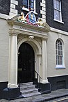 More images |
| Goldsmiths' Hall | City and County of the City of London | Livery Hall | 1829–35 | 4 January 1950 | TQ3221981357 51°30′56″N 0°05′45″W / 51.515671°N 0.095893°W / 51.515671; -0.095893 (Goldsmiths' Hall) | 1286469 |  More images |
| Skinners' Hall | City and County of the City of London | Livery Hall | Late 17th century | 4 January 1950 | TQ3255880861 51°30′40″N 0°05′28″W / 51.511134°N 0.091197°W / 51.511134; -0.091197 (Skinners' Hall) | 1064686 |  More images |
| Stationers' Hall | City and County of the City of London | Livery Hall | c. 1670 | 4 January 1950 | TQ3183181201 51°30′52″N 0°06′06″W / 51.51436°N 0.10154°W / 51.51436; -0.10154 (Stationers' Hall) | 1064742 | 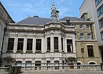 More images |
| Vintners Hall | City and County of the City of London | Livery Hall | 1840 | 4 January 1950 | TQ3239380809 51°30′39″N 0°05′37″W / 51.510706°N 0.093593°W / 51.510706; -0.093593 (Vintners Hall) | 1180690 |  More images |
Other
| Name | Location | Type | Completed [note 1] | Date designated | Grid ref.[note 2] Geo-coordinates | Entry number [note 3] | Image |
|---|---|---|---|---|---|---|---|
| Bank of England | Walbrook | Bank | Late 18th century to early 19th century | 4 January 1950 | TQ3273081211 51°30′51″N 0°05′19″W / 51.514239°N 0.088588°W / 51.514239; -0.088588 (Bank of England) | 1079134 | 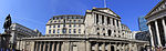 More images |
| College of Arms | City and County of the City of London | House and gate | 1956 | 4 January 1950 | TQ3203380971 51°30′44″N 0°05′55″W / 51.512246°N 0.098717°W / 51.512246; -0.098717 (College of Arms) | 1079147 | 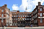 More images |
| Custom House | City and County of the City of London | Custom House | 1813–17 | 5 June 1972 | TQ3317280611 51°30′31″N 0°04′57″W / 51.508744°N 0.082449°W / 51.508744; -0.082449 (Custom House) | 1359193 |  More images |
| Dr. Johnson's House | City and County of the City of London | House | Late 17th century | 4 January 1950 | TQ3136781267 51°30′54″N 0°06′30″W / 51.515061°N 0.108198°W / 51.515061; -0.108198 (Dr. Johnson's House) | 1192738 |  More images |
| Gateway from Devereux Court, Middle Temple | Middle Temple, City and County of the City of London | Gate | Late 17th century | 4 January 1950 | TQ3108481009 51°30′46″N 0°06′45″W / 51.512808°N 0.11237°W / 51.512808; -0.11237 (Gateway from Devereux Court, Middle Temple) | 1193846 | 
|
| Guildhall | City and County of the City of London | Guildhall | Early 15th century | 4 January 1950 | TQ3248581384 51°30′57″N 0°05′31″W / 51.515851°N 0.092052°W / 51.515851; -0.092052 (Guildhall) | 1064675 |  More images |
| Lloyd's Building | City and County of the City of London | Commercial Office | 1978–86 | 19 December 2011 | TQ3315981082 51°30′47″N 0°04′57″W / 51.512979°N 0.082458°W / 51.512979; -0.082458 (Lloyd's Building) | 1405493 |  More images |
| St Bartholomew's Hospital Main North Block, East Block and West Block | City and County of the City of London | Courtyard | 1750-9 | 4 January 1950 | TQ3189281574 51°31′04″N 0°06′02″W / 51.517697°N 0.100522°W / 51.517697; -0.100522 (St Bartholomew's Hospital Main North Block, East Block and West Block) | 1079116 |  More images |
| Mansion House | City and County of the City of London | Courtyard | 1739–53 | 4 January 1950 | TQ3266981070 51°30′47″N 0°05′22″W / 51.512987°N 0.08952°W / 51.512987; -0.08952 (Mansion House) | 1064604 |  More images |
| Middle Temple Gatehouse | Middle Temple, City and County of the City of London | Inns of Court | 1684 | 4 January 1950 | TQ3114081104 51°30′49″N 0°06′42″W / 51.513649°N 0.111528°W / 51.513649; -0.111528 (Middle Temple Gatehouse) | 1064612 |  More images |
| Middle Temple Hall | Middle Temple, City and County of the City of London | Inns of Court | 1562–73 | 4 January 1950 | TQ3114880961 51°30′45″N 0°06′41″W / 51.512362°N 0.111466°W / 51.512362; -0.111466 (Middle Temple Hall) | 1064609 |  More images |
| Midland Bank, Poultry | City and County of the City of London | Commercial Office | 1924 | 5 June 1972 | TQ3262281144 51°30′49″N 0°05′25″W / 51.513663°N 0.090169°W / 51.513663; -0.090169 (Midland Bank, Poultry) | 1064598 |  More images |
| Numbers 4, 5 and 6 and attached pump, Staple Inn | High Holborn, City and County of the City of London | Inns of Chancery | c. 1586 | 24 October 1951 | TQ3115781585 51°31′05″N 0°06′40″W / 51.517967°N 0.111105°W / 51.517967; -0.111105 (Numbers 4, 5 and 6 and attached pump, Staple Inn) | 1246100 | 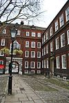 More images |
| Churchyard railings at St Paul's Cathedral | City and County of the City of London | Gate | 1714 | 5 June 1972 | TQ3197881099 51°30′48″N 0°05′58″W / 51.513409°N 0.099461°W / 51.513409; -0.099461 (Churchyard railings at St Paul's Cathedral) | 1194622 |  More images |
| Royal Exchange | City and County of the City of London | Exchange | 1841-4 | 4 January 1950 | TQ3282581144 51°30′49″N 0°05′14″W / 51.513615°N 0.087245°W / 51.513615; -0.087245 (Royal Exchange) | 1064713 | 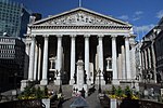 More images |
| Screen wall and gateways to the forecourt of St Paul's Cathedral Deanery | City and County of the City of London | Gate | 5 June 1972 | TQ3192181080 51°30′48″N 0°06′01″W / 51.513251°N 0.100289°W / 51.513251; -0.100289 (Screen wall and gateways to the forecourt of St Paul's Cathedral Deanery) | 1359191 |  | |
| St Paul's Cathedral Deanery | City and County of the City of London | Deanery | 1670 | 4 January 1950 | TQ3190081082 51°30′48″N 0°06′02″W / 51.513274°N 0.100591°W / 51.513274; -0.100591 (St Paul's Cathedral Deanery) | 1064683 |  More images |
| Bevis Marks Synagogue | City and County of the City of London | Synagogue | 1701 | 4 January 1950 | TQ3339581257 51°30′52″N 0°04′44″W / 51.514496°N 0.078993°W / 51.514496; -0.078993 (Bevis Marks Synagogue) | 1064745 |  More images |
| Temple Bar Gate | City and County of the City of London | Gate | 1806 | 15 June 2010 | TQ3196981195 51°30′51″N 0°05′58″W / 51.514274°N 0.099554°W / 51.514274; -0.099554 (Temple Bar Gate) | 1393844 |  More images
|
| St Bartholomew's Hospital Gatehouse | City and County of the City of London | Gate | 1702 | 4 January 1950 | TQ3186381599 51°31′05″N 0°06′03″W / 51.517929°N 0.10093°W / 51.517929; -0.10093 (St Bartholomew's Hospital Gatehouse) | 1079115 |  More images |
| The Monument | City and County of the City of London | Column | 1671-7 | 4 January 1950 | TQ3292380760 51°30′37″N 0°05′10″W / 51.510141°N 0.085978°W / 51.510141; -0.085978 (The Monument) | 1193901 |  More images
|
| Trinity House | City and County of the City of London | House | 1793-6 | 4 January 1950 | TQ3352280803 51°30′37″N 0°04′38″W / 51.510386°N 0.077336°W / 51.510386; -0.077336 (Trinity House) | 1079137 |  More images |
| Westminster Bank | City and County of the City of London | Bank (financial) | 1865 | 4 January 1950 | TQ3307081267 51°30′53″N 0°05′01″W / 51.514663°N 0.08367°W / 51.514663; -0.08367 (Westminster Bank) | 1191569 |  More images |
| 1 Kings Bench Walk | Inner Temple, City and County of the City of London | Inns of Court | Late 17th century | 4 January 1950 | TQ3131581071 51°30′48″N 0°06′32″W / 51.513312°N 0.10902°W / 51.513312; -0.10902 (1 Kings Bench Walk) | 1064647 |  |
| 7 Kings Bench Walk | Inner Temple, City and County of the City of London | Inns of Court | Late 17th century | 4 January 1950 | TQ3135180976 51°30′45″N 0°06′31″W / 51.512449°N 0.108537°W / 51.512449; -0.108537 (7 Kings Bench Walk) | 1064650 |  |
| 2 King's Bench Walk | Inner Temple, City and County of the City of London | Inns of Court | Late 17th century | 4 January 1950 | TQ3131681056 51°30′47″N 0°06′32″W / 51.513177°N 0.109011°W / 51.513177; -0.109011 (2 King's Bench Walk) | 1193156 |  More images |
| 4 King's Bench Walk | Inner Temple, City and County of the City of London | Inns of Court | Late 17th century | 4 January 1950 | TQ3134681033 51°30′47″N 0°06′31″W / 51.512962°N 0.10858577°W / 51.512962; -0.10858577 (4 King's Bench Walk) | 1193173 |  More images |
| 4–6 Pump Court | Middle Temple, City and County of the City of London | Inns of Court | 1686 | 4 January 1950 | TQ3116881031 51°30′47″N 0°06′40″W / 51.512986°N 0.111152°W / 51.512986; -0.111152 (4–6 Pump Court) | 1193870 |  |
| 1 Essex Court | Middle Temple, City and County of the City of London | Inns of Court | 1685 | 4 January 1950 | TQ3112581000 51°30′46″N 0°06′42″W / 51.512718°N 0.111783°W / 51.512718; -0.111783 (1 Essex Court) | 1286024 |  More images |
| 6 Kings Bench Walk | Inner Temple, City and County of the City of London | Inns of Court | Late 17th century | 4 January 1950 | TQ3134880998 51°30′46″N 0°06′31″W / 51.512648°N 0.108572°W / 51.512648; -0.108572 (6 Kings Bench Walk) | 1286279 |  |
| 1 Hare Court | Middle Temple, City and County of the City of London | Inns of Court | Late 17th century | 4 January 1950 | TQ3119381038 51°30′47″N 0°06′39″W / 51.513043°N 0.110789°W / 51.513043; -0.110789 (1 Hare Court) | 1359200 |  |
| 5 Kings Bench Walk | Inner Temple, City and County of the City of London | Inns of Court | Late 17th century | 4 January 1950 | TQ3134781014 51°30′46″N 0°06′31″W / 51.512792°N 0.10858°W / 51.512792; -0.10858 (5 Kings Bench Walk) | 1359177 | |
| 2 & 3 Essex Court | Middle Temple, City and County of the City of London | Inns of Court | 1677 | 4 January 1950 | TQ3110481011 51°30′46″N 0°06′43″W / 51.512821°N 0.112081°W / 51.512821; -0.112081 (2 & 3 Essex Court) | 1359199 |  More images |
| 3 Kings Bench Walk | Inner Temple, City and County of the City of London | Inns of Court | Late 17th century | 4 January 1950 | TQ3134681045 51°30′47″N 0°06′31″W / 51.513071°N 0.108583°W / 51.513071; -0.108583 (3 Kings Bench Walk) | 1064648 |  |
| 1–4 Holborn Bars | City and County of the City of London | House | 18th century | 14 May 1974 | TQ3115881588 51°31′05″N 0°06′40″W / 51.517994°N 0.111089°W / 51.517994; -0.111089 (1–4 Holborn Bars) | 1246103 |  More images |
See also
Notes
- ^ a b c The date given is the date used by Historic England as significant for the initial building or that of an important part in the structure's description.
- ^ a b c Sometimes known as OSGB36, the grid reference is based on the British national grid reference system used by the Ordnance Survey.
- ^ a b c The "List Entry Number" is a unique number assigned to each listed building and scheduled monument by Historic England.
External links
 Media related to Grade I listed buildings in the City of London at Wikimedia Commons
- v
- t
- e
- Aldersgate
- Aldgate
- Bassishaw
- Billingsgate
- Bishopsgate
- Bread Street
- Bridge
- Broad Street
- Candlewick
- Castle Baynard
- Cheap
- Coleman Street
- Cordwainer
- Cornhill
- Cripplegate
- Dowgate
- Farringdon Within
- Farringdon Without
- Langbourn
- Lime Street
- Portsoken
- Queenhithe
- Tower
- Vintry
- Walbrook
- 20 Fenchurch Street
- Bank of England Museum
- Barbican Centre
- Clockmakers' Museum
- College of Arms
- Dr Johnson's House
- Finsbury Circus
- Guildhall Art Gallery
- Leadenhall Market
- London Mithraeum
- London Stone
- Mansion House
- The Monument
- Museum of London
- One New Change
- Prince Henry's Room
- Royal Exchange
- St Paul's Cathedral
- Smithfield Market
structures
tube stations


- Coat of arms
- Flag
- History
- Listed buildings
- at Grade I
- at Grade II*
- Livery companies
- Lord Lieutenants
- Lord mayors
- Lord Mayor's Show
- Public art and memorials
- Sheriffs
- Street names
 Category

Portals:
 London
 Architecture
- ^ See Wikipedia St Paul's Cathedral.


