Eje Central
You can help expand this article with text translated from the corresponding article in Spanish. Click [show] for important translation instructions.
- Machine translation, like DeepL or Google Translate, is a useful starting point for translations, but translators must revise errors as necessary and confirm that the translation is accurate, rather than simply copy-pasting machine-translated text into the English Wikipedia.
- Do not translate text that appears unreliable or low-quality. If possible, verify the text with references provided in the foreign-language article.
- You must provide copyright attribution in the edit summary accompanying your translation by providing an interlanguage link to the source of your translation. A model attribution edit summary is
Content in this edit is translated from the existing Spanish Wikipedia article at [[:es:Eje Central Lázaro Cárdenas]]; see its history for attribution. - You may also add the template
{{Translated|es|Eje Central Lázaro Cárdenas}}to the talk page. - For more guidance, see Wikipedia:Translation.
 | |
|---|---|
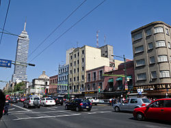 Eje Central at downtown Mexico City. | |
| Former name(s) | Avenida Panamá, Niño Perdido, San Juan de Letrán, Santa María la Redonda, Avenida de los 100 Metros |
| Namesake | Lázaro Cárdenas |
| Location | Mexico City, Mexico |
| Nearest metro station | See Metro |
| North end | Avenida Acueducto de Tenayuca |
| Major junctions | Monumento a la Raza Paseo de la Reforma |
| South end | Circuito Interior Av. Río Churubusco |
The Eje Central or Avenida Lázaro Cárdenas is an avenue in the Cuauhtémoc and Gustavo A. Madero boroughs of Mexico City, Mexico. It is part of a system called eje vial of roadways built by Carlos Hank González to modernize Mexico City for improved traffic flow through the city. As its name indicates, it runs through the central zones of the city, starting at Río de los Remedios Avenue (in the limits of Mexico City and Tlalnepantla, State of Mexico) and ending at Río Churubusco Avenue, near Eje Central metro station.[1]
Public transportation

Metro
Several Mexico City Metro stations are also located on Eje Central, most notably the Eje Central station of Line 12. Line 8 runs under Eje Central on its stretch that crosses downtown Mexico City.[2]
- Metro stations
- Politécnico

- Autobuses del Norte
- Instituto del Petróleo

- La Raza

- Garibaldi / Lagunilla


- Bellas Artes

- San Juan de Letrán
- Salto del Agua

- Doctores
- Obrera
- Lázaro Cárdenas

- Eje Central


Trolleybus
Trolleybus Line 1, also known as Corredor Cero Emisiones Eje Central Lázaro Cárdenas (Zero Emissions Corridor), runs through Eje Central from the Northern Bus Station to the Southern Bus Station (near Tasqueña metro station).
See also
- Eje vial, the whole system
- Streets in Mexico City
References
External links
Wikimedia Commons has media related to Eje Central Lázaro Cárdenas.
19°26′6.1″N 99°8′27.02″W / 19.435028°N 99.1408389°W / 19.435028; -99.1408389
- v
- t
- e
- Centro
- Barrio Chino
- La Merced
- Algarín
- Ampliación Asturias
- Asturias
- Atlampa
- Buenavista
- Buenos Aires
- Centro Urbano Benito Juárez
- Condesa
- Cuauhtémoc
- Doctores
- Esperanza
- Exhipódromo de Peralvillo
- Felipe Pescador
- Guerrero
- Hipódromo
- Hipódromo Condesa
- Juárez
- Maza
- Morelos
- Obrera
- Paulino Navarro
- Peralvillo
- Roma
- San Rafael
- San Simón Tolnáhuac
- Santa María Insurgentes
- Santa María la Ribera
- Tabacalera
- Tepito
- Tránsito
- Urbano Nonoalco Tlatelolco
- Vista Alegre
- Zona Rosa
- Alameda Central
- Antimonumenta
- Antimonumento +43
- Antimonumento +72
- Avenida Juárez
- Bench of Fidel Castro and Che Guevara
- Biblioteca Vasconcelos
- Buenavista railway station (current)
- Buenavista old train station
- Cruz de Mañozca
- El Sereno
- Former Aeromexico headquarters
- Forum Buenavista
- Fountain to Bartolomé de las Casas
- Fuente de la República
- Glorieta de la Palma
- Glorieta de los Insurgentes
- Hilton Mexico City Reforma
- How Doth the Little Crocodile
- Monumento a la Raza
- Monumento a la Revolución
- Monument to Pope John Paul II
- País de volcanes
- Palace of Iturbide
- Paseo de la Reforma
- Plaza Giordano Bruno
- Puerta 1808
- Taquería El Califa de León
- Torre del Caballito
- Torre Insignia
- Torre MAPFRE
- Historic buildings of Mexico City Centro
- Landmarks of Colonias Condesa and Roma
stations
- Allende
- Balderas
- Bellas Artes
- Buenavista
- Chabacano
- Chilpancingo
- Centro Médico
- Cuauhtémoc
- Doctores
- Garibaldi / Lagunilla
- Guerrero
- Hidalgo
- Hospital General
- Insurgentes
- Isabel la Católica
- Juárez
- La Viga
- Lagunilla
- Lázaro Cárdenas
- Misterios
- Niños Héroes / Poder Judicial CDMX
- Obrera
- Patriotismo
- Pino Suárez
- Revolución
- Salto del Agua
- San Antonio Abad
- San Cosme
- San Juan de Letrán
- Sevilla
- Tepito
- Tlatelolco
- Zócalo/Tenochtitlan
  | This article about the roads and road transport of Mexico is a stub. You can help Wikipedia by expanding it. |
- v
- t
- e
This article about a location in the Mexican Federal District is a stub. You can help Wikipedia by expanding it. |
- v
- t
- e


