Egglescliffe
Village and civil parish in County Durham, England
Village and civil parish in England
- Egglescliffe (Egglescliffe and Eaglescliffe Parish Council)
- Stockton-on-Tees
- County Durham
- North East
- Stockton South
- List of places
- UK
- England
- County Durham
Egglescliffe is a village and civil parish in County Durham, England.[1] Administratively it is located in the borough of Stockton-on-Tees.[2]
The civil parish is in the Teesdale with a population of 8,559 at the 2011 Census.[3] In the 2021 census the group of interconnected villages in the parish and Preston-on-Tees had a population of 10,250, in the larger village to small town classification.[4] It has Egglescliffe School (secondary and sixth-form), an light industrial estate, two railway stations and golf club. Villages in the parish include Eaglescliffe, Urlay Nook, Sunningdale, Orchard and a development on the former Allens West MOD site.[5]

The village is on top of a hill with the River Tees at the bottom, overlooking Yarm on the other bank. It had a 2001 population of around 595,[6] There is a Church of England primary school, small kids play area, farms, allotments and a public house (called the Pot and Glass).
History

North of the River Tees was not recorded in the 1068 Domesday Book. The parish church is dedicated to St John the Baptist and there has been a place of worship on the site since the twelfth century.
Bishop Skirlaw of Durham built a stone bridge, across the Tees in 1400 which still stands. An iron replacement was built in 1805, but it fell down in 1806.[7]
Governance
It was in the palatinate of Durham (the prince-bishop of Durham's domain) from its establishment until 1836 when it became a standard type of county. 1974 reforms lead to Egglescliffe being placed under the Stockton district of Cleveland county. The district became a unitary authority in 1996 and a part of the ceremony county Durham.
Etymology
Egglescliffe has been characterised by Victor Watts as "a difficult name".[8][9]: 55 The name is first attested in an 1172 copy of a 1085 charter, as Eggasclif; forms containing l in the earlier part of the name, such as Egglesclif, are first attested in the 1190s, but are rarer in the Middle Ages.[9]: 54–55 The second element of the name is certainly from Old English clif, "steep slope", presumably referring to the slope from Egglescliffe down to the River Tees.
The consensus among authorities in the twentieth century was that the first element came from Latin ecclesia "church" via Brittonic (where the borrowing of ecclesia is represented today by Welsh eglwys). If so, the name once meant "church-slope".[9]: 55 However, by 2007 Victor Watts had noted that Egglescliffe is distant from other examples of more reliably attested "Eccles" names, and that the l is usually absent from the first element in medieval sources. He concluded that Egglescliffe originated with the personal name Ecgwulf, which had the nickname form Ecgi. Thus the place was routinely known both as "Ecgwulf's slope" (producing forms like Egglesclif) and as "Ecgi's slope" (producing forms like Eggasclif), until the former type eventually became dominant.[9]: 56 [10][11]
Egglescliffe gave its name to their neighbouring Eaglescliffe, whose name is simply a variant of Egglescliffe produced by folk-etymological adaptation of the unfamiliar Eggles- to the familiar Eagles-.[12]
Geography
Egglescliffe parish villages | ||||||||||||||||
|---|---|---|---|---|---|---|---|---|---|---|---|---|---|---|---|---|
| ||||||||||||||||


The parish is divided by railway lines, such as the Tees Valley line and Northallerton–Eaglescliffe line. Vehicles can only get from the east to west of the parish to its far south or via the A66 road.
The parish includes the villages of Egglescliffe, Eaglescliffe, Sunningdale and Orchard. Urlay Nook and the former Allens West site are in development. There is also an industrial estate which includes the former Whitley Springs farm buildings.
The main road through eastern parish is the A135 Yarm Road which was part of the old route of the A19 until the 1970s when it was diverted east of Thornaby. The A67 runs through the west of the parish. Nearby large towns include Stockton-on-Tees (north), Middlesbrough (north east), Darlington (west) and Hartlepool (north east).
Gallery
-
 War memorial
 -
 Parish hall
 -
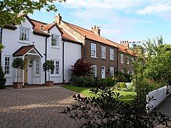 Church Road cottages
 -
 Pot & Glass public house


See also
References
- ^ County Durham, England's Cities, Towns, Villages and Settlements
- ^ Councils in Stockton-on-Tees, County Durham - Yahoo! Local UK
- ^ "Civil Parish population 2011". Retrieved 24 July 2015.
- ^ "Towns and cities, characteristics of built-up areas, England and Wales: Census 2021". Retrieved 3 August 2021.
- ^ "History of the Parish". www.egglescliffeandeaglescliffe-pc.org.uk. Egglescliffe & Eaglescliffe Parish Council. Retrieved 26 August 2021.
- ^ "Area Snapshot". Archived from the original on 27 September 2007. Retrieved 21 June 2007.
- ^ Historic England. "Yarm Bridge Over River Tees (1105658)". National Heritage List for England. Retrieved 13 September 2021.
- ^ The Cambridge Dictionary of English Place-Names, Based on the Collections of the English Place-Name Society, ed. by Victor Watts (Cambridge: Cambridge University Press, 2004), s.v. Egglescliffe; ISBN 9780521362092.
- ^ a b c d Victor Watts, The Place-Names of County Durham Part One: Stockton Ward, ed. by Paul Cavill, English Place-Name Society, 83 (Nottingham: English Place-Name Society, 2007).
- ^ Victor Watts, A Dictionary of Durham Place-Names, English Place-Name Society Popular Series, 3 (Nottingham: English Place-Name Society, 2002), pp. 38–39.
- ^ Bethany Fox, 'The P-Celtic Place-Names of North-East England and South-East Scotland', The Heroic Age, 10 (2007), http://www.heroicage.org/issues/10/fox.html (appendix at http://www.heroicage.org/issues/10/fox-appendix.html).
- ^ The Cambridge Dictionary of English Place-Names, Based on the Collections of the English Place-Name Society, ed. by Victor Watts (Cambridge: Cambridge University Press, 2004), s.v. Eaglescliffe; ISBN 9780521362092.
External links
- Egglescliffe & Eaglescliffe parish council website
![]() Media related to Egglescliffe at Wikimedia Commons
Media related to Egglescliffe at Wikimedia Commons
The borough of Stockton-on-Tees | |||||||
|---|---|---|---|---|---|---|---|
| Major Settlements | |||||||
| Villages | |||||||
| Governance |
| ||||||
| Culture, leisure and tourism | |||||||
| Services |
| ||||||
| Organisations |
| ||||||
| Sport | |||||||
| Waterways |
| ||||||
| Transport |
| ||||||
| Historic | |||||||
| Other |
| ||||||
 Category Category | |||||||
 | This Stockton-on-Tees location article is a stub. You can help Wikipedia by expanding it. |
- v
- t
- e


