Dotson Ice Shelf
Ice shelf in Marie Byrd Land, Antarctica

Dotson Ice Shelf is an ice shelf about 30 miles (50 km) wide between Martin Peninsula and Bear Peninsula on the coast of Marie Byrd Land in Antarctica. It was first mapped by the U.S. Geological Survey from air photos obtained by U.S. Navy Operation Highjump in January 1947, and was named by the Advisory Committee on Antarctic Names for Lieutenant William A. Dotson, US Navy, formerly Officer in Charge of the Ice Reconnaissance Unit of the Naval Oceanographic Office, killed in a plane crash in Alaska in November 1964 while on an ice reconnaissance mission.[1]
-
 Dotson Ice Shelf in east of map
 -
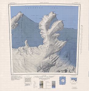
 Dotson Ice Shelf in west of map


Further reading
- David A. Lilien, Ian Joughin, Benjamin Smith, and David E. Shean, Changes in flow of Crosson and Dotson ice shelves, West Antarctica, in response to elevated melt, The Cryosphere, 12, 1415–1431, 2018 https://doi.org/10.5194/tc-12-1415-2018
- Goldberg, D. N., Gourmelen, N., Kimura, S., Millan, R., & Snow, K., How Accurately Should We Model Ice Shelf Melt Rates? Archived 2022-03-07 at the Wayback Machine, Geophysical Research Letters, 46, 189–199. https://doi.org/10.1029/2018GL080383
References
- ^ "Dotson Ice Shelf". Geographic Names Information System. United States Geological Survey, United States Department of the Interior. Retrieved 2012-01-26.
![]() This article incorporates public domain material from "Dotson Ice Shelf". Geographic Names Information System. United States Geological Survey.
This article incorporates public domain material from "Dotson Ice Shelf". Geographic Names Information System. United States Geological Survey.
74°24′S 112°22′W / 74.400°S 112.367°W / -74.400; -112.367
- v
- t
- e


