Djenné Cercle
Cercle in Mopti Region, Mali
Djenné Cercle | |
|---|---|
Cercle | |
 | |
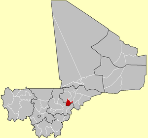 Location of the Cercle of Djenné in Mali | |
| Country |  Mali Mali |
| Region | Mopti Region |
| Admin HQ | Djenné |
| Area | |
| • Total | 4,563 km2 (1,762 sq mi) |
| Population (2009 Census)[2] | |
| • Total | 207,260 |
| • Density | 45/km2 (120/sq mi) |
| Time zone | UTC+0 (GMT) |
Djenné Cercle is an administrative subdivision of the Mopti Region of Mali. The administrative center (chef-lieu) is the town of Djenné. In the 2009 census the cercle had a population of 207,260 people.
Administrative subdivisions
The Djenné Cercle is divided into 12 communes:
- Dandougou Fakala
- Derary
- Djenné
- Fakala
- Femaye
- Kéwa
- Madiama
- Néma Badenyakafo
- Niansanarié
- Ouro Ali
- Pondori
- Togué Mourari
References
- ^ Synthèsis des Plans de Securité Alimentaire des Commune du Cercle de Djenné 2006-2010 (PDF) (in French), Commissariat à la Sécurité Alimentaire, République du Mali, USAID-Mali, 2006, archived from the original (PDF) on 2012-05-19.
- ^ Resultats Provisoires RGPH 2009 (Région de Mopti) (PDF) (in French), République de Mali: Institut National de la Statistique, archived from the original (PDF) on 2012-07-27.
- v
- t
- e


13°55′N 4°35′W / 13.917°N 4.583°W / 13.917; -4.583
 | This Mopti Region location article is a stub. You can help Wikipedia by expanding it. |
- v
- t
- e


