Delamere, Cheshire
Village in Cheshire, England
Human settlement in England
- Delamere and Oakmere[1]
- Cheshire
- North West
- Eddisbury
Delamere is a village and former civil parish, now in the parish of Delamere and Oakmere, within the unitary authority area of Cheshire West and Chester, in the ceremonial county of Cheshire, England. It is approximately 7 miles (11 km) west of Northwich. The population of the civil parish taken at the 2011 census was 1,025.[2] The name of the village comes from the French de la mer "of the sea". The civil parish was abolished on 1 April 2015 to form "Delamere and Oakmere"; parts also went to Kelsall, Utkinton and Cotebrook and Willington.[3][4]
The civil parish was well known for the Delamere Forest, an expanse of oak, pine and sycamore trees which forms the largest woodland in Cheshire.[5] It includes the hills of Old Pale and Eddisbury Hill, part of the Mid Cheshire Ridge.
There are several cafés, including the Station House Café at Delamere railway station and Delamere Café in Delamere Forest. Other services include a primary school (Delamere C of E Academy[6]), shop (Delamere Stores), community centre[7] and public house, the Vale Royal Abbey Arms on the A556.[8]
Gallery of images of Delamere
-
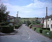 Frith Avenue
 -
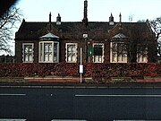 Delamere school
 -
 Station house


Transport
Delamere is served by Delamere railway station which opened on 22 June 1870. There are regular stopping services to both Chester and Manchester Piccadilly
Geodesy
On Pale Heights (National Grid SJ543696) was the origin (meridian) of the first Ordnance Survey one inch mapping of the whole of the United Kingdom.[9]
Notable people
- Alan Mayers (b. 1937), English footballer
- Henry Wilbraham (1825–1883), English mathematician
See also
 Cheshire portal

References
- ^ "The Parish Council – Delamere and Oakmere".
- ^ "Parish population 2011". Retrieved 30 May 2015.
- ^ "DELAMERE". GENUKI. Retrieved 15 April 2018.
- ^ "Cheshire West and Chester Registration District". UKBMD. Retrieved 1 September 2023.
- ^ Forestry Commission: Delamere Forest Park: Information Archived 16 April 2018 at the Wayback Machine (accessed 13 January 2013)
- ^ "Home page". Delamere Academy. Retrieved 25 September 2018.
- ^ "Delamere Community Centre". Cheshire Community Action. Retrieved 25 September 2018.
- ^ "Home page". Vale Royal Abbey Arms. Retrieved 25 September 2018.
- ^ Adams, Brian (1998–99). "198 years and 153 meridians, 152 defunct" (PDF). Streetlines. The Charles Close Society for the Study of Ordnance Survey Maps: 2. Archived from the original (PDF) on 26 October 2016. Retrieved 27 February 2016.
External links
Wikimedia Commons has media related to Delamere.
- v
- t
- e
- Acton Bridge
- Agden
- Aldersey
- Aldford and Saighton
- Allostock
- Alvanley
- Anderton with Marbury
- Antrobus
- Ashton Hayes and Horton-cum-Peel
- Aston
- Bache
- Backford
- Barnton
- Barrow
- Barton
- Beeston
- Bostock
- Broxton
- Burwardsley
- Byley
- Capenhurst
- Carden
- Chester Castle
- Chidlow
- Chorlton
- Chowley
- Christleton
- Churton
- Clotton Hoofield
- Clutton
- Coddington
- Comberbach
- Croughton
- Crowton
- Cuddington, Eddisbury
- Cuddington, Malpas
- Darnhall
- Davenham
- Delamere and Oakmere
- Dodleston
- Duckington
- Duddon and Burton
- Dunham-on-the-Hill and Hapsford
- Dutton
- Eaton and Eccleston
- Elton
- Farndon
- Frodsham
- Golborne David
- Great Boughton
- Great Budworth
- Guilden Sutton
- Handley
- Hargrave and Huxley
- Hartford
- Harthill
- Helsby
- Huntington
- Ince
- Kelsall
- Kingsley
- Kingsmead
- Lach Dennis
- Lea-by-Backford
- Ledsham
- Little Budworth
- Little Leigh
- Little Stanney
- Littleton
- Lostock Gralam
- Malpas
- Manley
- Marston
- Mickle Trafford and District
- Mollington
- Moston
- Mouldsworth
- Moulton
- Neston
- Nether Peover
- No Man’s Heath and District
- Norley
- Northwich
- Poulton and Pulford
- Puddington
- Rowton
- Rudheath
- Rushton
- Saughall and Shotwick Park
- Shocklach Oviatt and District
- Sproston
- Stanthorne and Wimboldsley
- Stoak
- Stretton
- Sutton Weaver
- Tarporley
- Tarvin
- Tattenhall and District
- Thornton-le-Moors
- Threapwood
- Tilston
- Tiverton and Tilstone Fearnall
- Tushingham-cum-Grindley, Macefen and Bradley
- Upton-by-Chester
- Utkinton and Cotebrook
- Waverton
- Weaverham
- Wervin
- Whitegate and Marton
- Whitley
- Wigland
- Willington
- Wincham
- Winsford
- Aldford
- Ashton Hayes
- Bickley
- Bradley
- Bridge Trafford
- Bruen Stapleford
- Buerton
- Burton
- Caldecott
- Caughall
- Chorlton-by-Backford
- Church Shocklach
- Churton by Aldford
- Churton by Farndon
- Churton Heath
- Claverton
- Cotton Abbotts
- Cotton Edmunds
- Crewe-by-Farndon
- Delamere
- Dunham-on-the-Hill
- Duddon
- Eaton
- Eccleston
- Edge
- Edgerley
- Foulk Stapleford
- Golborne Bellow
- Grafton
- Hampton
- Hapsford
- Hatton
- Hockenhull
- Hoole Village
- Horton-by-Malpas
- Horton-cum-Peel
- Huxley
- Iddinshall
- Kings Marsh
- Larkton
- Lea Newbold
- Lower Kinnerton
- Macefen
- Marlston-cum-Lache
- Mickle Trafford
- Newton by Malpas
- Newton-by-Tattenhall
- Oakmere
- Oldcastle
- Overton
- Picton
- Poulton
- Prior's Heys
- Pulford
- Saighton
- Saughall
- Shocklach Oviatt
- Shotwick
- Shotwick Park
- Stanthorne
- Stockton
- Tattenhall
- Tilstone Fearnall
- Tiverton
- Tushingham cum Grindley
- Utkinton
- Wimbolds Trafford
- Wimboldsley
- Woodbank
- Wychough
 | This Cheshire location article is a stub. You can help Wikipedia by expanding it. |
- v
- t
- e


