Cwm Penmachno
Human settlement in Wales
- Bro Machno
- Conwy
- Aberconwy
- Aberconwy
Cwm Penmachno (historically called Tre-Gynwal[1]) is a village at the head of Cwm Machno in North Wales.
History
The village was built in the 1860s as a quarry settlement. The Penmachno quarry lay immediately south and above the settlement. Higher up the valley was the Rhiwbach slate quarry, which was formerly linked by the Rhiwbach Tramway to the Ffestiniog Railway at Blaenau Ffestiniog.[2] Streams flow from the steep-sided valley, forming the source of the River Machno, which flows through the larger village of Penmachno before joining the River Conwy south of Betws-y-Coed.[3]
Facilities
The village attracts tourists, particularly mountain bikers, kayakers, canoeists and walkers. The Penmachno Mountain Bike Trail starts at the car park located between Cwm Penmachno and Penmachno.[3]
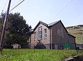
There is a community centre and Heritage Room in the village at the former Shiloh Chapel.[4][5]
Situated near the end of the valley is The Latymer School's outdoor centre, Ysgol Latymer Outdoor Pursuits Centre (occupying the buildings of the former primary school). The school runs residential trips each year for year 7 and year 9 pupils, as well as various Geography and PE trips. The Latymer School purchased this centre in Snowdonia National Park so that its pupils could get to know each other better and to discover their individual skills.[6]
-
 Terraced housing built for quarry workers (Rhiw Bach Terrace).
 -
 Cwm Penmachno from the south (quarry in foreground), 1969.
 -
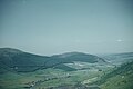
 The head of Cwm Machno, the village and quarry in the background.
 -
 Capel Shiloh, Cwm Penmachno.
 -
 The Ysgol Latymer Outdoor Pursuits Centre.


References
- ^ Caernarvonshire XXIX.NE (Map). Ordnance Survey. 1912.
- ^ "Rhiwbach Slate Quarry and its tramway".
- ^ a b "Cwm Penmachno, Conwy County". Wales Directory. Archived from the original on 22 September 2022. Retrieved 18 April 2015.
- ^ "New heritage room for Cwm Penmachno". Daily Post.
- ^ "Shiloh Community Centre". Conwy Borough Council. Archived from the original on 18 April 2015.
- ^ "Ysgol Latymer Outdoor Pursuits Centre". Latymer School. Archived from the original on 4 May 2015.
External links
Wikimedia Commons has media related to Cwm Penmachno.
- Photographs of Cwm Penmachno Slate Quarry
- v
- t
- e


