Curraghboy
Village in County Roscommon, Ireland
Village in Connacht, Ireland
Curraghboy An Currach Buí | |
|---|---|
Village | |
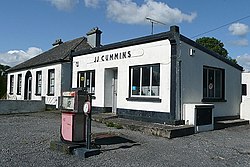 Disused garage at Curraghboy | |
| 53°29′02″N 8°06′36″W / 53.484°N 8.110°W / 53.484; -8.110 | |
| Country | Ireland |
| Province | Connacht |
| County | County Roscommon |
| Time zone | UTC+0 (WET) |
| • Summer (DST) | UTC-1 (IST (WEST)) |
Curraghboy (Irish: An Currach Buí, meaning 'the yellow marsh')[1] is a rural village in County Roscommon, Ireland. It lies 14 km (8.7 mi) northwest of Athlone on the R362 regional road. It has one public house and two grocery shops. It also has an indoor handball alley, Roman Catholic church and a national (primary) school.[2]
See also
References
- v
- t
- e
Places in County Roscommon
County town: Roscommon

Townlands
- Aghnasurn
- Ardcarn
- Arigna
- Athleague
- Ballinlough
- Ballintober
- Ballyfarnon
- Ballyforan
- Ballyleague
- Bellanagare
- Brideswell
- Castlecoote
- Castleplunket
- Cloonbonniffe
- Cloonfad
- Cloontuskert
- Cootehall
- Cornafulla
- Cortober
- Croghan
- Curraghboy
- Drum
- Dysart
- Four Roads
- Frenchpark
- Fuerty
- Keadue
- Killukin
- Kilteevan
- Kiltoom
- Knockvicar
- Knockcroghery
- Lecarrow
- Lisacul
- Loughglinn
- Old Town
- Portrun
- Rahara
- Roosky
- Taghmaconnell
- Tarmonbarry
- Tulsk
- List of townlands of County Roscommon
- Category:Mountains and hills of County Roscommon
- Category:Rivers of County Roscommon
- Category:Geography of County Roscommon
 | This article related to the geography of County Roscommon, Ireland is a stub. You can help Wikipedia by expanding it. |
- v
- t
- e


