Croix de Chavaux station
Metro station in Paris, France
48°51′29″N 2°26′09″E / 48.858055°N 2.435764°E / 48.858055; 2.435764| Preceding station | Following station | |||
|---|---|---|---|---|
| Robespierre towards Pont de Sèvres | Line 9 | Mairie de Montreuil Terminus | ||
Location | |
|---|---|
  Croix de Chavaux Place Jacques Duclos Location within Paris |
Croix de Chavaux (French pronunciation: [kʁwa də ʃavo]) is a station on line 9 of the Paris Métro, at the crossroads called Croix de Chavaux. The "chavaux" in the name of the crossroads is probably a corruption of the French "chevaux" ("horses"). The "croix" (French for "cross) may be a reference to the crossroads or to a wayside cross.
History
The station was opened on 14 October 1937 with the extension of the line from Porte de Montreuil to Mairie de Montreuil.
In 2019, the station was used by 4,954,717 passengers, making it the 85th busiest of the Métro network out of 302 stations.[1]
In 2020, the station was used by 2,839,564 passengers amidst the COVID-19 pandemic, making it the 60th busiest of the Métro network out of 305 stations.[2]
Passenger services
Access
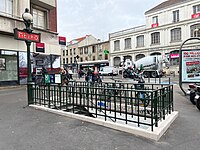
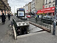
The station has 5 accesses:
- Access 1: Place Jacques-Duclos
- Access 2: rue de Paris
- Access 3: Boulevard Chanzy – Center commercial
- Access 4: rue Kléber – Office du Tourisme
- Access 5: Place du Marché
Station layout
| Street Level | ||
| B1 | Mezzanine | |
| Line 9 platforms | Side platform, doors will open on the right | |
| Westbound | ←  | |
| Eastbound | → | |
| Side platform, doors will open on the right | ||
Platforms
The station has a standard configuration with 2 tracks surrounded by 2 side platforms.
Other connections
The station is also served by lines 102, 115, 122, and 127 of the RATP bus network, and at night, by lines N16 and N34 of the Noctilien bus network.
Gallery
-
 Entrance 1
 -
 Entrance 2
 -
 Entrance 4
 -
 Entrance 5
 -


Wikimedia Commons has media related to Croix de Chavaux (Paris Metro).
References
- Roland, Gérard (2003). Stations de métro. D’Abbesses à Wagram. Éditions Bonneton.
- ^ "Trafic annuel entrant par station du réseau ferré 2019". dataratp2.opendatasoft.com (in French). Archived from the original on 21 January 2022. Retrieved 13 February 2022.
- ^ "Trafic annuel entrant par station du réseau ferré 2020". data.ratp.fr (in French). Archived from the original on 21 January 2022. Retrieved 13 February 2022.
- v
- t
- e
- Pont de Sèvres


- Billancourt
- Marcel Sembat
- Porte de Saint-Cloud
- Exelmans
- Michel-Ange–Molitor (eastbound only)


- Michel-Ange–Auteuil (westbound only)
- Jasmin
- Ranelagh
- La Muette
- Rue de la Pompe
- Trocadéro

- Iéna
- Alma–Marceau
- Franklin D. Roosevelt

- Saint-Philippe du Roule
- Miromesnil

- Saint-Augustin

- Havre–Caumartin


- Chaussée d'Antin–La Fayette

- Richelieu–Drouot

- Grands Boulevards
- Bonne Nouvelle
- Strasbourg–Saint-Denis

- République


- Oberkampf
- Saint-Ambroise
- Voltaire
- Charonne
- Rue des Boulets
- Nation

- Buzenval
- Maraîchers
- Porte de Montreuil

- Robespierre
- Croix de Chavaux
- Mairie de Montreuil
- Aristide Briand (planned)
- Montreuil-Hôpital (planned)
This article related to the Paris Métro is a stub. You can help Wikipedia by expanding it. |
- v
- t
- e


