Crizbav
Commune in Brașov, Romania

Coat of arms

Location within the county
(2021-12-01)[1]
507081
Crizbav (Hungarian: Krizba, German: Krebsbach) is a commune in Brașov County, Transylvania, Romania. It is composed of two villages, Crizbav and Cutuș (Kutastelep).
Geographical setting
Crizbav is located 24 km (15 mi) northwest of the county seat, the city of Brașov. It lies on the banks of the Crizbav River, on a high plateau of the Burzenland depression, at the southern foot of the Perșani Mountains. The commune belongs to the Burzenland historic region and is situated 10 km (6.2 mi) from national road DN13 [ro] (Feldioara commune) and 6 km (3.7 mi) from DN1 (Dumbrăvița commune).
Crizbav borders:
- to the north – the communes Comăna and Măieruș;
- to the east – the commune Feldioara;
- to the south – the commune Hălchiu;
- to the west – the communes Dumbrăvița and Părău.
The Crizbav commune altitude is 572 m (1,877 ft), decreasing to Feldioara and Satu Nou at 513–514 m (1,683–1,686 ft). Higher elevations in the commune are Horezu Peak, at 1,055 m (3,461 ft) and Citadel Peak, at 1,104 m (3,622 ft), both located in the foothills of the Perșani Mountains, approximately 6 km (3.7 mi) from the village center.
Short history
The first written documents of the material and spiritual life of the commune dates back to Roman times. Evidence is provided by the Crizbav Citadel, which experts consider that it was built by the Romans after the occupation of Dacia, but certain written attestations are from 1335.
The history of the village is rich, beginning with the German name of the city, (Krebs Bach = Crabs Valley) and continuing with the use of Crizbav Citadel as military observation tower, as confirmed by the "Diploma of King Louis the Great" of March 12, 1344, or that of Prince Stephen Báthory of October 30, 1484.
Demographics
At the 2011 census, Crizbav had 2,518 inhabitants; 83.1% of those were Romanians and 16.1% Hungarians. At the 2021 census, the commune had a population of 2,952, of which 80.79% were Romanians and 9.55% Hungarians.[2]
Landmarks
- Archaeological site "La Cetate" (Crizbav) code LMI 2004 ISA-11273-BV formed by:
- medieval fortification, LMI 2004 Code: BV-ImA-11273.01
- Hallstatt settlement, LMI 2004 Code: BV-ImA-11273.02
- Dacian fortress, LMI 2004 Code: BV-ImA-11273.03
- Heldenburg Citadel code LMI 2004: BV-II-I A-11662
References
-
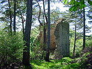 Archaeological site "La Cetate"
 -
 Lutheran church in Crizbav
 -
 Orthodox church in Crizbav
 -
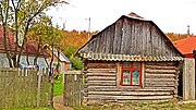 House in Cutuș


- v
- t
- e

- Apața
- Augustin
- Beclean
- Bod
- Bran
- Budila
- Bunești
- Cața
- Cincu
- Comăna
- Cristian
- Crizbav
- Drăguș
- Dumbrăvița
- Feldioara
- Fundata
- Hălchiu
- Hărman
- Hârseni
- Hoghiz
- Holbav
- Homorod
- Jibert
- Lisa
- Măieruș
- Mândra
- Moieciu
- Ormeniș
- Părău
- Poiana Mărului
- Prejmer
- Racoș
- Recea
- Sâmbăta de Sus
- Sânpetru
- Șercaia
- Șinca
- Șinca Nouă
- Șoarș
- Tărlungeni
- Teliu
- Ticușu
- Ucea
- Ungra
- Vama Buzăului
- Viștea
- Voila
- Vulcan
Wikimedia Commons has media related to Crizbav, Brașov.
 | This Brașov County location article is a stub. You can help Wikipedia by expanding it. |
- v
- t
- e


