Churches Complex

The Churches Complex in Jebel Ali Village, Dubai, United Arab Emirates, is an area for a number of churches and temples of different religious denominations, especially Christian denominations.[1] It is located immediately to south of the Al Muntazah residential neighbourhood complex.[2]
Churches and temples
Churches and temples in the complex include:[1]
- St Francis of Assisi Catholic Church[3]
- Christ Church Jebel Ali Anglican Church[4]
- Dubai Evangelical Church Centre (DECC)
- St Mina Copts Orthodox Church[5]
- The Mar Thoma Parish church
- Mor Ignatius Jacobite Syrian Orthodox Cathedral[6]
- Archdiocese of Roum Orthodox Church[7]
- Gurunanak Darbar Dubai Sikh Temple[8]
- Hindu Temple, Jebel Ali[9]
Gallery
-
 St Francis of Assisi Church
 -
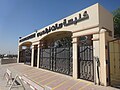 St Francis of Assisi Church entrance
 -
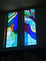 St Francis of Assisi Church stained glass window
 -
 Dubai Evangelical Church Centre (DECC)
 -
 The Mar Thoma Parish Church
 -
 Mor Ignatius Jacobite Syrian Orthodox Cathedral
 -
 Gurunanak Darbar Dubai Sikh Temple


Location and transport
The Churches Complex is close to the Ibn Battuta Mall to the north.[10] The nearest Dubai Metro station is the Energy metro station on the Red Line to the west. Both are connected to the complex by the F44 feeder bus service.[11]
References
- ^ a b Pittenger, Fernanda. "The 6 Best Churches & Cathedrals in Jebel Ali, Emirate of Dubai". thingstodopost.org. Retrieved 9 March 2022.
- ^ "Al Muntazah Complex: Neighbourhood, Jebel Ali District, Dubai". Propsearch.ae. UAE. Retrieved 26 May 2021.
- ^ "St. Francis of Assisi Catholic Church: Jebel Ali, Dubai, United Arab Emirates". sfacja.org. Retrieved 26 May 2021.
- ^ "Christ Church Jebel Ali". christchurchjebelali.org. Retrieved 26 May 2021.
- ^ "St Mina Copts Orthodox Church Jebel Ali Dubai". Facebook. Retrieved 9 March 2022.
- ^ "Mor Ignatius Jacobite Syrian Orthodox Cathedral". dubaichurch.com. Retrieved 9 March 2022.
- ^ "Archdiocese Of Roum Orthodox Church". Trip.com. Retrieved 9 March 2022.
- ^ "Gurunanak Darbar Dubai". gurudwaradubai.com. Retrieved 9 March 2022.
- ^ "Hindu Temple". 2gis.ae. 2GIS. Retrieved 9 March 2022.
- ^ "Al Muntazah Complex: Project Overview". dubaidevelopments.com. Dubai Developments. Retrieved 26 May 2021.
- ^ "F44 Bus Route in Dubai – Time Schedule, Stops and Maps". yourdubaiguide.com. Your Dubai Guide. 17 October 2018. Retrieved 9 March 2022.
External links
 Media related to Churches Complex at Wikimedia Commons
- v
- t
- e
- Al Ayas
- Al Garhoud
- Al Khawaneej
- Al Mizhar
- Al Rashidiya
- Al Nahda
- Al Qusais
- Al Twar
- Dubai Airport
- Mirdif
- Muhaisnah
- Mushraif
- Nad Shamma
- Oud Al Muteena
- Umm Ramool
- Wadi Alamardi
- Al Bada
- Al Barsha
- Al Hamriya
- Al Hudaiba
- Al Jaddaf
- Al Jafilia
- Al Karama
- Al Kifaf
- Al Manara
- Al Mankhool
- Al Merkad
- Al Quoz
- Al Rifa
- Al Safa
- Al Satwa
- Al Shindagha
- Al Souk Al Kabir
- Al Sufouh
- Al Thanyah
- Al Wasl
- Business Bay
- Downtown Dubai
- Dubai Marina
- Jumeirah
- Jumeirah Bay
- Jumeirah Island 2
- Madinat Dubai Al Melaheyah
- Nakhlat Jumeirah
- Oud Metha
- Trade Centre 1
- Trade Centre 2
- Umm Al Sheif
- Umm Hurair
- Umm Suqeim
- World Islands
- Zabeel
- Al Khairan First
- Al Kheeran
- Al Warqaa
- Nad Al Hammar
- Ras Al Khor
- Wadi Alshabak
- Al Wajeha Al Bahriah
- Dubai Investment Park
- Hessyan
- Jabal Ali
- Madinat Al Mataar
- Mena Jabal Ali
- Nakhlat Jabal Ali
- Saih Shuaib
- Al Barsha South
- Al Hebiah
- Bu Kadra
- Hadaeq Sheikh Mohammed Bin Rashid
- Me'aisem
- Nadd Al Shiba
- Nadd Hessa
- Ras Al Khor Industrial Area
- Wadi Al Safa
- Warsan
- Al Fagaa
- Al Hathmah
- Al Layan
- Al Lesaily
- Al Marmoom
- Al O'shoosh
- Al Selal
- Al Yalayis
- Al Yufrah
- Ghadeer Barashy
- Grayteesah
- Hefair
- Mugatrah
- Saih Al-Dahal
- Saih Al Salam
- Saih Shua'alah
- Umm Nahad
25°1′34.54″N 55°6′50.15″E / 25.0262611°N 55.1139306°E / 25.0262611; 55.1139306
 | This Dubai-related article is a stub. You can help Wikipedia by expanding it. |
- v
- t
- e
 | This United Arab Emirates location article is a stub. You can help Wikipedia by expanding it. |
- v
- t
- e


