Casola in Lunigiana
Comune in Tuscany, Italy

Coat of arms
Location of Casola in Lunigiana

44°12′N 10°11′E / 44.200°N 10.183°E / 44.200; 10.183
(30 June 2017)[2]
54014
Casola in Lunigiana is a comune (municipality) in the Province of Massa and Carrara in the Italian region Tuscany, located about 100 kilometres (62 mi) northwest of Florence and about 20 kilometres (12 mi) north of Massa.
Main sights
- Church of Santa Felicita. Known from the late 13th century, it was later restored in Baroque style.
- Pieve of Sts. Cornelio e Cipriano, at Codiponte. Probably existing before 793 AD, it includes a basilica with a nave and two aisles, dating from the 12th century.
- Pieve of San Pietro, at Offiano. Of Romanesque origin, it was modified in Baroque style in the 18th century.
- Church of Santa Margherita, at Regnano
- Church of Sant'Andrea (15th century), at Ugliancaldo.
-
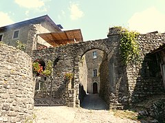 Gate of the historical centre.

References
![]() Media related to Casola in Lunigiana at Wikimedia Commons
Media related to Casola in Lunigiana at Wikimedia Commons
- v
- t
- e
| Authority control databases |
|
|---|
This Province of Massa-Carrara location article is a stub. You can help Wikipedia by expanding it. |
- v
- t
- e


