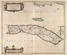
Cara Island
Iland located off the west coast of Kintyre in Scotland
66 ha (1⁄4 sq mi)

Cara Island (Scottish Gaelic: Cara) is a small island which is located off the west coast of Kintyre in Scotland.
Geography and etymology
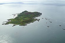
Cara is one kilometre (one-half nautical mile) south of Gigha. It is accessible from Gigha.
Cara has a translation in Gaelic as "dearest" or "dear one". Cara is a popular girl's name in the local area and in Scotland in general.
History
Cara Island is owned by the Macdonald family of Largie, Kintyre and is reputed to be the only island still in the possession of a direct descendant of the Lords of the Isles. The only habitable building on the island is Cara House.[6]
The liner Aska was sunk on 22 September 1940 on rocks northwest of the island after being struck by German bombers.
Wildlife
Cara is well known for a herd of feral goats, which still thrive on the wild landscape.
Mythology

Cara is famous as the home of the Uruisg/broonie, the familiar spirit of the Macdonald of Largie family. A rock formation known as the Broonie's Chair is found at the extreme southern tip of the island. In addition, there is also a renowned cliff Pilibín Mór affectionately nicknamed by the locals as Hick's Lump
.
References
- ^ Area and population ranks: there are c. 300 islands over 20 ha in extent and 93 permanently inhabited islands were listed in the 2011 census.
- ^ 2001 UK Census per List of islands of Scotland
- ^ Haswell-Smith, Hamish (2004). The Scottish Islands. Edinburgh: Canongate. ISBN 978-1-84195-454-7.
- ^ Get-a-map (Map). Ordnance Survey.
- ^ Anderson, Joseph (Ed.) (1893) Orkneyinga Saga. Translated by Jón A. Hjaltalin & Gilbert Goudie. Edinburgh. James Thin and Mercat Press (1990 reprint). ISBN 0-901824-25-9
- ^ "Cara House, Isle of Gigha". britishlistedbuildings.co.uk. Retrieved 27 September 2016.
External links
Wikimedia Commons has media related to Cara Island.
- v
- t
- e
Argyll Islands

| ||
|---|---|---|
| Settlements |  | |
| Other "non OS settlements" |
| |
| Surrounding islands |
| |
| Other places |
| |
Portal:
 Scotland
55°38′N 5°45′W / 55.633°N 5.750°W / 55.633; -5.750
 | This Argyll and Bute location article is a stub. You can help Wikipedia by expanding it. |
- v
- t
- e


