Braamt
Village in Gelderland, Netherlands
51°55′26″N 6°15′52″E / 51.92393°N 6.26440°E / 51.92393; 6.26440 (2021)[1]
6941[1]
Braamt is a village in the municipality of Montferland in the province of Gelderland, the Netherlands.
History
It was first mentioned in 1241 as Brameth, and means "place where blackberries grow".[3] De Kemnade is a havezate near Braamt on the Oude IJssel. The estate was first mentioned in 1418, and the tower dates from the 16th century.[4] In 1840, it was home to 292 people. In 1918, a school was built and the church dates from 1950.[5]
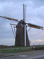
The Braamse Molen is a wind mill from 1856. In the 1990s, it was in very poor condition. It was purchased in 2017, and in 2021 the restoration of the wind mill commenced.[6]
Gallery
-
 Stroomboek
 -
-
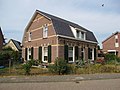 House in Braamt


References
- ^ a b c "Kerncijfers wijken en buurten 2021". Central Bureau of Statistics. Retrieved 23 March 2022.
- ^ "Postcodetool for 6941AA". Actueel Hoogtebestand Nederland (in Dutch). Het Waterschapshuis. Retrieved 23 March 2022.
- ^ "Braamt - (geografische naam)". Etymologiebank (in Dutch). Retrieved 23 March 2022.
- ^ Ronald Stenvert & Sabine Broekhoven (2000). "Braamt" (in Dutch). Zwolle: Waanders. ISBN 90 400 9406 3. Retrieved 23 March 2022.
- ^ "Braamt". Plaatsengids (in Dutch). Retrieved 23 March 2022.
- ^ "Braamse Molen / Koenders Möl". Molen database (in Dutch). Retrieved 23 March 2022.
Wikimedia Commons has media related to Braamt.
 | This Gelderland location article is a stub. You can help Wikipedia by expanding it. |
- v
- t
- e


