Bilecik Province
Province of Turkey
Province in Turkey
Bilecik Province Bilecik ili | |
|---|---|
Province | |
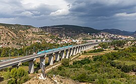 High speed train at Bilecik | |
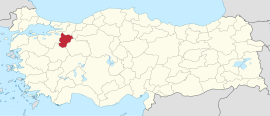 Location of the province within Turkey | |
| Country | Turkey |
| Seat | Bilecik |
| Government | |
| • Governor | Şefik Aygöl |
| Area | 4,179 km2 (1,614 sq mi) |
| Population (2022)[1] | 228,673 |
| • Density | 55/km2 (140/sq mi) |
| Time zone | UTC+3 (TRT) |
| Area code | 0228 |
| Website | www |
Bilecik Province (Turkish: Bilecik ili) is a province in midwest Turkey, neighboring Bursa to the west, Kocaeli and Sakarya to the north, Bolu to the east, Eskişehir to the southeast and Kütahya to the south. Its area is 4,179 km2,[2] and its population is 228,673 (2022).[1] Most of the province laid down in Marmara Region but eastern parts of Gölpazarı and Söğüt district and districts of İnhisar and Yenipazar remained in Black Sea Region, smaller southeastern parts of Bozüyük and Söğüt remained in Central Anatolia Region and smaller southwestern part of Bozüyük remained in Aegean Region.
History
The region was inhabited as early as 3000 BC, and was part of the territory controlled by such notable civilizations as the Hittites (1400–1200 BC), the Phrygians (1200–676 BC), Lydians (595–546 BC), Persians (546–334 BC), Romans (74–395 AD) and Byzantians (395 AD to late 13th century, with two brief occupations by Umayyads in between).
The region also contains Söğüt, the small town where the Kayi tribe of Turkomans under Osman Gazi united as the Ottomans and founded the Ottoman Beylik which would later develop into the Ottoman Empire which was founded in 1299, and is the source of important archeological as well as cultural artifacts.
Geography

Bilecik Province contains wide array of geographical and climatic zones in its borders. The province is dominated by hills and deep valleys. The western end of the Anatolian Plateau is also located in the province. Sakarya River and Karasu are the most important rivers in the province.[4]
Districts

Bilecik province is divided into 8 districts (capital district in bold):
Demographics
| Year | Pop. | ±% p.a. |
|---|---|---|
| 1927 | 113,660 | — |
| 1935 | 125,421 | +1.24% |
| 1940 | 127,977 | +0.40% |
| 1950 | 137,030 | +0.69% |
| 1960 | 145,699 | +0.62% |
| 1970 | 138,856 | −0.48% |
| 1980 | 147,001 | +0.57% |
| 1990 | 175,526 | +1.79% |
| 2000 | 194,326 | +1.02% |
| 2010 | 225,381 | +1.49% |
| 2020 | 218,717 | −0.30% |
| Source:Turkstat[5][6][7] | ||
Sites of interest
In Söğüt a site of interest is the Ethnographical Museum.
The town Bilecik is famous for its numerous restored Turkish houses.
Some other sites of interest in the province are: Osman Gazi and Orhan Gazi mosques, Seyh Edebali and Mal Hatun mausoleums, Köprülü Mehmet Pasha mosque, Köprülü Caravanserai, Kaplikaya tombs, Rüstem Pasha mosque, and Gülalan Pavilion.
Gallery
-
 A view from Çengeller village in Gölpazarı
 -
 Sheikh Edebali tomb
 -
 Bilecik Cultural Center
 -
 The türbe of Dursun Fakih in Söğüt
 -
 Küçükelmalı Nature Park Pond
 -
 Bilecik Mosque
 -
 Bilecik Osman Gazi Mosque


See also
References
- ^ a b "Address-based population registration system (ADNKS) results dated 31 December 2022, Favorite Reports" (XLS). TÜİK. Retrieved 19 September 2023.
- ^ "İl ve İlçe Yüz ölçümleri". General Directorate of Mapping. Retrieved 19 September 2023.
- ^ "Present and future Köppen-Geiger climate classification maps at 1-km resolution". Nature Scientific Data. DOI:10.1038/sdata.2018.214.
- ^ "Coğrafi Yapı". bilecik.tarimorman.gov.tr. Retrieved 2023-03-08.
- ^ Genel Nüfus Sayımları
- ^ Turkstat
- ^ "The Results of Address Based Population Registration System, 2020". Turkish Statistical Institute. Archived from the original on 2021-10-28. Retrieved 7 December 2021.
External links
Wikimedia Commons has media related to Bilecik Province.
- (in Turkish) Bilecik governor's official website
- (in Turkish) Bilecik municipality's official website
- Bilecik weather forecast information
- (in Turkish) Yerel Yöneylem Kalkınma Derneği - Gölpazarı
- (in Turkish) Bayırköy's local website
- (in Turkish) Virtual platform of Bilecik Archived 2019-06-02 at the Wayback Machine
- (in Turkish) Bilecik hayat platform Archived 2021-05-09 at the Wayback Machine
- v
- t
- e
Bilecik Province of Turkey


| Istanbul | |
|---|---|
| West Marmara | |
| Aegean | |
| East Marmara | |
| West Anatolia | |
| Mediterranean | |
| Central Anatolia | |
| West Black Sea | |
| East Black Sea | |
| Northeast Anatolia | |
| Central East Anatolia | |
| Southeast Anatolia | |
Metropolitan municipalities are bolded.
Authority control databases | |
|---|---|
| International |
|
| National |
|
| Geographic |
|
40°06′24″N 30°07′33″E / 40.10667°N 30.12583°E / 40.10667; 30.12583


