Beverly Boulevard
Thoroughfare in Los Angeles, United States
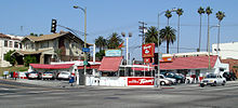 Original Tommy's at the corner of Rampart and Beverly Blvd. | |
| Location | Los Angeles, California, U.S. |
|---|---|
| Nearest metro station |   Vermont/Beverly Vermont/Beverly |
| West end | Santa Monica Boulevard in Beverly Hills |
| East end | Glendale Boulevard in Westlake |
Beverly Boulevard is one of the main east–west thoroughfares in Los Angeles, in the U.S. state of California. It begins off Santa Monica Boulevard in Beverly Hills and ends on the Lucas Avenue overpass near downtown Los Angeles to become 1st Street. A separate Beverly Boulevard (carrying Montebello Transit line 40 and nearby Atlantic E Line station) begins off 3rd Street and Pomona Boulevard in East Los Angeles, runs through Montebello and Pico Rivera, and becomes Turnbull Canyon Road in Whittier near Rose Hills Memorial Park.
Background
Beverly Boulevard from the Beverly Center


On the right 5x zoom showing the La Cienega Boulevard intersection (studio zone center) in the foreground (2023)
Work on paving Beverly Boulevard through Northwest Los Angeles began in the 1910s, making it one of Los Angeles's first boulevards.[1]
The Boulevard's most famous stretch is in West Hollywood, where it passes Cedars-Sinai Medical Center and the Beverly Center Mall (at the intersection with La Cienega Boulevard). In addition, much of the Fairfax District is centered on Beverly Boulevard. The Grove is southeast of Beverly and Fairfax. The intersection of Beverly and La Cienega is the center of the studio zone (also known as the "thirty-mile zone"), the area that Los Angeles-based entertainment industry unions consider as "local" for purposes of work rules.[citation needed]
Beverly Boulevard runs parallel to Melrose Avenue to the north and 3rd Street to the south. It passes directly through the Wilshire Country Club.[citation needed]
The famous CBS Television City is located on the corner of Beverly and Fairfax, opposite The Grove.[2] Original Tommy's, a famous Southern California burger chain, is located at the corner of Rampart and Beverly Boulevards.[3] Also situated on Beverly Boulevard are studios belonging to Westlake Recording Studios, noted as the site where music albums such as Michael Jackson's Thriller were recorded.[4]
La Cienega Design Quarter
The area of Beverly Boulevard that intersects La Cienega Boulevard and its satellite streets is part of the La Cienega Design Quarter. Its shops and galleries house many antiques, furniture, rugs, accessories, and art.
Education and transportation
- Belmont High School is located at Beverly Boulevard and Belmont Avenue.
- Metro Local line 14 operates on Beverly Boulevard.
- The Metro B Line serves an underground station at Vermont Avenue.
External links
Wikimedia Commons has media related to Beverly Boulevard (Los Angeles County, California).
References
 Los Angeles portal

- ^ "CITY TO SEA HIGHWAY AIM. First-street Property Owners Take Initial Step; Petition Council for Opening Great Thoroughfare; Agree on Specifications and Secure Signatures". Los Angeles Times. June 24, 1916. p. I11.
- ^ "Some History About CBS Television City".
- ^ "History of the Original Tommy's". Archived from the original on May 31, 2009. Retrieved June 1, 2009.
- ^ "Studios". Westlake Recording Studios. Archived from the original on May 13, 2016. Retrieved January 17, 2017.
- v
- t
- e
- Alameda St.
- Alvarado St.
- Atlantic Blvd./Atlantic Ave.
- Avalon Blvd.
- Aviation Blvd.
- Azusa Ave.
- Beverly Dr.
- Beverly Glen Blvd.
- Broadway
- Cahuenga Blvd.
- Central Ave.
- Crenshaw Blvd.
- Doheny Dr.
- Fairfax Ave.
- Fair Oaks Ave.
- Figueroa St.
- Garfield Ave./Cherry Ave.
- Glendale Blvd./Brand Blvd.
- Gower St.
- Grand Ave.
- Highland Ave.
- Hill St.
- Hoover
- La Brea Ave./Hawthorne Blvd.
- La Cienega Blvd.
- Lake Ave.
- Laurel Canyon Blvd./Crescent Heights Blvd.
- Lincoln Blvd.
- Los Angeles St.
- Main St.
- Normandie Ave.
- Ocean Ave.
- Orange Grove Blvd.
- Robertson Blvd.
- Rosemead Blvd./Lakewood Blvd.
- San Fernando Rd.
- San Pedro St.
- Sawtelle Blvd.
- Sepulveda Blvd.
- Sierra Hwy.
- Sierra Madre Blvd.
- Soto St.
- Pacific Blvd./Long Beach Blvd.
- Pacific Coast Hwy.
- Vermont Ave.
- Vine St.
- Western Ave.
- Westwood Blvd.
- Wilcox Ave.
- Adams Blvd.
- Alondra Blvd.
- Angeles Crest Hwy.
- Arrow Hwy.
- Artesia Blvd.
- Bandini Blvd.
- Beverly Blvd.
- Carroll Ave.
- Carson St.
- Century Blvd.
- Colima Rd./Golden Springs Dr.
- Compton Blvd./Marine Ave.
- Culver Blvd.
- Del Amo Blvd.
- El Segundo Blvd.
- Florence Ave.
- Franklin Ave.
- Garvey Ave.
- Hollywood Blvd.
- Huntington Dr.
- Imperial Hwy.
- Jefferson Blvd.
- Lomita Blvd.
- Los Feliz Blvd.
- Manchester Ave./Firestone Blvd.
- Manhattan Beach Blvd.
- Martin Luther King Jr. Blvd.
- Melrose Ave.
- Montana Ave.
- Mulholland Dr.
- Nadeau
- Obama Blvd.
- Olympic Blvd.
- Pico Blvd.
- Rosecrans Ave.
- Santa Monica Blvd.
- Slauson Ave.
- Sunset Blvd./Cesar Chavez Ave.
- Temple St.
- Vernon Ave.
- Venice Blvd.
- Washington Blvd.
- Whittier Blvd.
- Wilshire Blvd.
- Arrow Hwy.
- Balboa Blvd.
- Cahuenga Blvd.
- Coldwater Canyon Ave.
- Colorado Blvd.
- Foothill Blvd.
- Glenoaks Blvd.
- Lankershim Blvd.
- Laurel Canyon Blvd.
- Mulholland Dr.
- Reseda Blvd.
- Riverside Dr.
- San Fernando Rd.
- Sepulveda Blvd.
- Sierra Hwy.
- Sunland Blvd./Vineland Ave.
- Topanga Canyon Blvd.
- Valley Blvd.
- Van Nuys Blvd.
- Ventura Blvd.
- Victory Blvd.
traffic circles
- Gower Gulch
- Hollywood and Vine
- Naud Junction
- SM Entertainment Square
- Sunset Junction
- Abbot Kinney Blvd.
- California Incline
- Centinela Ave./Bundy Dr.
- Pacific Coast Hwy.
- San Vicente Blvd.
- Telegraph Rd.
- Gaffey St.
- Western Ave.
- 77 Sunset Strip
- "All I Wanna Do"
- "Blue Jay Way"
- "Dead Man's Curve"
- "Down Rodeo"
- "Free Fallin'"
- "I Love L.A."
- King of the Mountain
- "LA Devotee"
- Mulholland Drive
- "Pico and Sepulveda"
- Sunset Boulevard (film, musical)
- Vine Street (+Live+ song)
All un-suffixed roads are streets unless otherwise noted.
34°04′33″N 118°19′40″W / 34.07583°N 118.32778°W / 34.07583; -118.32778


