Berdorf
Commune in Echternach, Luxembourg
Berdorf Bäerdref | |
|---|---|
 | |
 Coat of arms | |
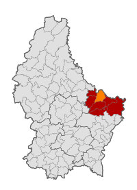 Map of Luxembourg with Berdorf highlighted in orange, and the canton in dark red | |
| Coordinates: 49°49′15″N 6°20′55″E / 49.8208°N 6.3486°E / 49.8208; 6.3486 | |
| Country |  Luxembourg Luxembourg |
| Canton | Echternach |
| Government | |
| • Mayor | Joé Nilles |
| Area | |
| • Total | 21.93 km2 (8.47 sq mi) |
| • Rank | 46th of 100 |
| Highest elevation | 384 m (1,260 ft) |
| • Rank | 65th of 100 |
| Lowest elevation | 165 m (541 ft) |
| • Rank | 10th of 100 |
| Population (2023) | |
| • Total | 2,219 |
| • Rank | 84th of 100 |
| • Density | 100/km2 (260/sq mi) |
| • Rank | 73rd of 100 |
| Time zone | UTC+1 (CET) |
| • Summer (DST) | UTC+2 (CEST) |
| LAU 2 | LU0001003 |
| Website | www |
Berdorf (Luxembourgish: Bäerdref) is a commune and small town in eastern Luxembourg. It is part of the canton of Echternach, which is part of the district of Grevenmacher. Berdorf is known for the sandstone rocks surrounding it.
As of 2024[update], the town of Berdorf, which lies in the centre of the commune, has a population of 1,466.[1] Other towns within the commune include Bollendorf-Pont, Grundhof, and Weilerbach.
-
 Berdorf town hall
 -
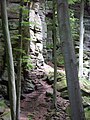 Sandstone Rocks
 -
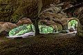 Hohllay ("hollow rock")


Population
Graphs are unavailable due to technical issues. There is more info on Phabricator and on MediaWiki.org. |
References
External links
 Media related to Berdorf at Wikimedia Commons
Places adjacent to Berdorf | ||||||||||||||||
|---|---|---|---|---|---|---|---|---|---|---|---|---|---|---|---|---|
| ||||||||||||||||


- v
- t
- e
Authority control databases | |
|---|---|
| International |
|
| Other |
|
 | This article related to the geography of Echternach canton is a stub. You can help Wikipedia by expanding it. |
- v
- t
- e


