Beit David
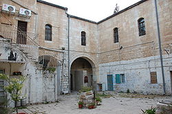
Beit David was the fourth Jewish neighborhood outside the walls of Jerusalem. This courtyard neighborhood was established in 1873.[1]
History
Beit David was founded as an almshouse for Jews on a plot of land donated by a kollel.[2] It was named for the philanthropist, David Reis. The name also alludes to the historical House of David and to the book known as Beit David, a treatise on Jewish law written by Joseph Ben David in the 18th century.[3] Because Beit David was far from the kollel's center in the Old City, it contained a synagogue and 10 apartments to ensure the existence of a minyan.[2]
The residence of Abraham Isaac Kook, Israel's first Askenanzic chief rabbi was on the second floor of the building, added in 1922. The Rabbi Kook House is now a museum of the life of Rabbi Kook.[4] The Museum of Psalms, located on the ground floor for many years, featured the paintings of Moshe Tzvi HaLevi Berger, a Kabbalist and painter. Berger was evicted in 2014 to make room for a yeshiva[5]
See also
References
- ^ Buzzy Gordon Frommer's Jerusalem Day by Day John Wiley & Sons, Oct 11, 2010 Google Books
- ^ a b Zvi Shilony (1993). "Ashkenazi Jewish Almshouses in Jerusalem". Journal of Cultural Geography. 14: 35–48. doi:10.1080/08873639309478379.
- ^ Eisenberg, Ronald L. The Streets of Jerusalem: Who, What, Why. Jerusalem: Devora, 2006. ISBN 9781932687545 WorldCat link as given in Google Books
- ^ Peeking through the highrises: famed Jerusalem street's old architectural glories, Haaretz
- ^ Museum of Psalms
- v
- t
- e
Neighborhoods of Jerusalem
Jerusalem neighborhoods in East Jerusalem are depicted in green, those in West Jerusalem in blue (see Green Line).
- Armenian Quarter
- Christian Quarter
- Muristan
- Jewish Quarter
- Muslim Quarter
- Bab al-Huta
- Arzei HaBira
- Batei Ungarin
- Beit David
- Beit Ya'akov
- Beit Yisrael
- Bukharim
- Downtown Triangle
- Geula
- Givat HaVradim
- Givat Ram
- Jerusalem Gateway
- Katamon
- Kerem Avraham
- Kiryat HaLeom
- Kiryat HaMemshala
- Kiryat Shmuel
- Kiryat Shomrei Emunim
- Kiryat Wolfson
- Mahane Israel
- Mahane Yehuda
- Mea Shearim
- Mekor Baruch
- Mount Zion
- Musrara
- Nahalat Shiv'a
- Nachlaot
- Nayot
- Neve Granot
- Neve Sha'anan
- Rehavia
- Romema
- Russian Compound
- Sha'arei Hesed
- Shmuel HaNavi
- Talbiya (Komemiyut)
- Yemin Moshe
- Zikhron Moshe
- Al-Ram
- Beit Hanina
- Dahiyat al–Barid
- Ezrat Torah
- French Hill
- Givat HaMivtar
- Givat Moshe
- Har Hotzvim
- Kafr 'Aqab
- Kiryat Belz
- Kiryat Itri
- Kiryat Mattersdorf
- Kiryat Sanz
- Ma'alot Dafna
- Mount Scopus
- Neve Yaakov
- Pisgat Ze'ev
- Ramat Eshkol
- Ramat Shlomo
- Ramot
- Ramot Polin
- Sanhedria
- Sanhedria Murhevet
- Shikun Chabad
- Shuafat
- Tel Arza
- Unsdorf
- Arab al–Jahalin
- American Colony
- Al Bustan
- Al-Issawiya
- At-Tur
- Bab a-Zahara
- Bethany
- Ir David
- Jabel Mukaber
- Kiryat Menachem Begin
- Ma'ale HaZeitim
- Nahalat Shimon
- Nof Zion
- Ras al-Amud
- Sheikh Jarrah
- Shimon HaTzadik
- Silwan
- Wadi al-Joz
- Abu Tor
- Arnona
- Baka
- Beit Safafa
- East Talpiot
- German Colony
- Gilo
- Givat HaMatos
- Givat Oranim
- Givat Massuah
- Greek colony
- Har Homa
- Katamonim
- Malha
- Mekor Chaim
- Pat
- Ramat Rachel
- San Simon
- Sharafat
- Sur Baher
- Talpiot
- Umm Tuba
- Atarot
- Batei Munkacs
- Batei Saidoff
- Even Yisrael
- Ezrat Yisrael
- Kirya Ne'emana
- Knesset Yisrael
- Lifta
- Mahane Yehuda
- Mamilla
- Mazkeret Moshe
- Mishkenot Sha'ananim
- Mughrabi Quarter
- Ohel Shlomo
- Sha'arei Yerushalayim
- Sheikh Badr
- Zikhron Tuvya
- Zikhron Yosef
- See also: Courtyard neighborhood • Ring Neighborhoods
| Authority control databases: National |
|
|---|
31°46′59.08″N 35°13′11.35″E / 31.7830778°N 35.2198194°E / 31.7830778; 35.2198194


