Barzeh, Syria
Municipality in Damascus Governorate, Syria
Barzeh بَرْزَة | |
|---|---|
Municipality | |
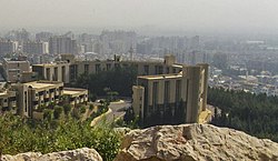 Barzeh as seen from Mount Qasioun | |
 District map of Damascus | |
33°33′24″N 36°19′14″E / 33.55667°N 36.32056°E / 33.55667; 36.32056 | |
| Country |  Syria Syria |
| Governorate | Damascus Governorate |
| City | Damascus |
| Population (2004)[1] | |
| • Total | 47,339 |
| Time zone | UTC+3 (EET) |
| • Summer (DST) | UTC+2 (EEST) |
| Climate | BSk |
Barzeh or Barza (Arabic: بَرْزَة, romanized: Barzah, also transliterated Berzé) is a municipality and a neighborhood to the north of Damascus, Syria.[2] According to the Syria Central Bureau of Statistics, Barzeh had a population of 47,339 in the 2004 census.[1]
History
Barzeh's foundation dates back to at least Roman times. There is archaeological evidence of Roman and Aramean tombs in the area. Traditionally it has always been a town of the Ghouta, and therefore closely linked to agriculture. Rice, oil and olives and various types of fruit are produced. In the 20th century, it was absorbed into Damascus.
Syrian Civil War
The municipality has been active in the Syrian civil war. The Sunni Barzeh al-Balad neighborhood was largely pro-rebel. However, the neighboring Alawite "slum" Ish al-Warwar is largely pro-government.[3][4] The Barzeh area has been under truce between the rebels and government since 2014.[3][5]
On 1 April 2015, the rebels (Jaish al-Islam and the Free Syrian Army's First Brigade) launched a military campaign to expel the Islamic State of Iraq and the Levant from the Barzeh and Qaboun neighborhoods,[6][7] which ended in success three days later.[8] On 8 February 2016, an IS car bomb targeting a government officer's club killed eight people in Masakin Barzeh.[9] On 29 May 2017 the Syrian government regained control of the entire district.[10]
Neighborhoods
- Al-Abbas (pop. 23,112)
- Barza al-Balad (pop. 31,634)
- Ish al-Warwar (pop. 20,458)
- Al-Manara (pop. 10,199)
- Masakin Barzeh (pop. 15,705)
- An-Nuzha (pop. 6,488)
Population
- 1922: 2000 inhabitants
- 1935: 3500 inhabitants
- 1950: 4,239 inhabitants
- 1960: 6554 inhabitants
- 2004: 47,339 inhabitants
Education
The Higher Institute for Applied Sciences and Technology has its main campus in the Hameesh area[11] of Barzeh.
References
- ^ a b Damascus city population
- ^ Khaled Yacoub Oweis (18 July 2012). "Battles break out near Syrian presidential palace". Reuters. Archived from the original on 24 September 2015. Retrieved 19 July 2012.
- ^ a b Lina Sinjab (18 January 2014). "In Syria, few conciliatory signs as peace talks loom". BBC. Retrieved 9 July 2016.
- ^ Nir Rosen (12 October 2011). "Assad's Alawites: An Entrenched Community". Al-Jazeera. Retrieved 9 July 2016.
- ^ Joshua Hersh (26 February 2014). "Syrian Government Sees An End Game, Block By Block". Huffington Post. Retrieved 9 July 2016.
- ^ "ISIS encroaches on east Damascus". NOW. 17 April 2015. Archived from the original on 17 September 2016. Retrieved 29 August 2016.
- ^ "Damascus: Islam Army attacks ISIS bases in Qaboun, Barzeh neighborhoods". Zaman al-Wasl. 17 April 2015. Retrieved 29 August 2016.
- ^ "Syrian rebels defeat ISIS in Damascus". Ara News. 20 April 2015. Archived from the original on 19 October 2017. Retrieved 29 August 2016.
- ^ Anne Barnard (9 February 2015). "ISIS, in a First, Says It Was Behind Attack in Syrian Capital". The New York Times. Retrieved 29 August 2016.
- ^ "Evacuation of rebels from Damascus district complete, city governor says". Reuters. 29 May 2017. Retrieved 29 May 2017.
- ^ "HIAST". Facebook. Retrieved 18 April 2018.
- v
- t
- e
other landmarks
- Al-Azem Palace
- Khan As'ad Pasha
- Straight Street
- Mausoleum of Saladin
- Umayyad Mosque
- Citadel of Damascus
- Grand Serail of Damascus
- Khadra Palace
- Nur al-Din Bimaristan
- Maktab Anbar
- Hejaz Train Station
- Statue of Saladin
- Tomb of the Unknown Soldier
- Temple of Jupiter
- Tishreen Palace
- Al-Shaab Palace
- October War Panorama
| Catholic | |
|---|---|
| Eastern Orthodox | |
| Oriental Orthodox |
education
- National Museum of Damascus
- Al-Assad National Library
- Damascus Opera House
- Damascus University
- Syrian Virtual University
- International University for Science and Technology
- Syrian Private University
- Arab International University
- Higher Institute for Applied Science and Technology
- Higher Institute of Music in Damascus
- Higher Institute for Dramatic Arts
- National Institute of Administration
- Damascus Community School
- Lycée Charles de Gaulle
- Shami Hospital
- Bakdash (ice cream parlor)
- Bawabet Dimashq
- Havana Cafe
- Beit al-Mamlouka Hotel
- Blue Tower Hotel
- Four Seasons Hotel Damascus
- Baghdad Street
- Marjeh Square
- Rawda Square
- Sabaa Bahrat Square
- Umayyad Square
- Yusuf al-Azma Square
| Venues |
|
|---|---|
| Clubs |
|
(List of rulers)
- Aram
- Siege (634)
- Jund Dimashq
- Burid dynasty
- Siege (1148)
- Eyalet
- Affair
- Protocol
- State
- Battle (1941)
- International Airport
- 1976 Pan Arab Games
- World Military Cup 1977
- International Film Festival
- 1981 Azbakiyah bombing
- 1986 bombings
- 1992 Pan Arab Games
- Spring
- 2002 West Asian Football Federation Championship
- 2004 WABA Champions Cup
- Declaration
- 2008 Arab Capital of Culture
- 2008 Arab League summit
- 2008 car bombing
- 2011 bombings
- 2011–2012 clashes
- January 2012 al-Midan bombing
- March 2012 bombings
- April 2012 bombings
- May 2012 bombings
- Battle (2012)
- July 2012 bombing
- 2017 bombings
 Category

 | This article about a location in Damascus Governorate, Syria is a stub. You can help Wikipedia by expanding it. |
- v
- t
- e


