Aurès
Natural region in Algeria
Aurès أَورَاس | |
|---|---|
Natural region | |
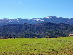 Overall overview of the Chelia mont from Yabous region, Khenchela province | |
| Country | Algeria |
| Elevation | 450 m (1,480 ft) |
Aurès (Arabic: أَوْرَاس, romanized: Awrās) is a natural region located in the mountainous area of the Aurès range in eastern Algeria. The region includes the Algerian provinces of Batna, Tebessa, Constantine, Khenchela, Oum El Bouaghi, Souk Ahras and Biskra.
History
The Awras or Aurès region is characterized both by its mountain terrain and by the Berber Chaoui ethnic group that historically has inhabited the area. The rugged terrain of the Aurès has made the region one of the less developed areas in the Maghreb. Traditionally the women of the region wore tattoos.[1]
It was in the Aurès region that the Algerian War of Independence was started by Berber independence fighters such as Mostefa Ben Boulaïd, who operated from the area.[2] A district of Algeria that existed during and after the War of Independence, from 1962 to 1974, was named after this region.
See also
- Chakhchoukha
References
External links
Wikimedia Commons has media related to Aurès.
- Algeria - Ethnic Groups and Languages
- Les Aurès - Algérie[permanent dead link]
- v
- t
- e
Cultural regions of Algeria

| Authority control databases: National |
|
|---|
35°20′N 6°40′E / 35.333°N 6.667°E / 35.333; 6.667
 | This Algeria location article is a stub. You can help Wikipedia by expanding it. |
- v
- t
- e


