Apéndice Island
Island in Graham Land, Antarctica
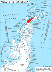
Apéndice Island, also known as Isla Telegrafista Rivera or Sterneck Island, is an island in Hughes Bay lying north of Renzo Point on Relyovo Peninsula and west of Sucia Point on Sladun Peninsula, Graham Land in Antarctica. The name appears on an Argentine government chart of 1957. It forms part of the Cierva Point and offshore islands Important Bird Area and ASPA 134.[1]
See also
References
- ^ "Cierva Point and offshore islands". BirdLife data zone: Important Bird Areas. BirdLife International. 2012. Archived from the original on 10 July 2007. Retrieved 13 December 2012.
 This article incorporates public domain material from "Apéndice Island". Geographic Names Information System. United States Geological Survey.
- v
- t
- e
- Dakshin Gangotri Glacier
- Svarthamaren Mountain
- Yukidori Valley
- Apéndice Island
- Avian Island
- Biscoe Point
- Bransfield Strait
- Cierva Point
- Dion Islands
- Eastern Dallmann Bay
- Emperor Island
- Green Island
- Lagotellerie Island
- Litchfield Island
- Midas Island
- Moss Islands
- Mount Flora
- Rothera Point
- South Bay
- Admiralty Bay
- Ardley Island
- Byers Peninsula
- Cape Shirreff
- Collins Point
- Coppermine Peninsula
- Crater Lake
- Deception Island
- Discovery Bay
- Fildes Peninsula
- Harmony Point
- Kroner Lake
- Lions Rump
- Mount Pond
- Narębski Point
- Pendulum Cove
- Port Foster
- Potter Peninsula
- Ronald Hill
- San Telmo Island
- South East Point
- Stonethrow Ridge
- Suffield Point
- Telefon Bay
64°11′S 61°2′W / 64.183°S 61.033°W / -64.183; -61.033
 | This Danco Coast location article is a stub. You can help Wikipedia by expanding it. |
- v
- t
- e


