Amboyna Cay
Island in the South China Sea
07°53′31″N 112°55′17″E / 7.89194°N 112.92139°E / 7.89194; 112.92139 Vietnam
 China
China Malaysia
 Philippines
 Taiwan Vietnam
Amboyna Cay, also known as Vietnamese: Đảo An Bang; Malay: Pulau Amboyna Kecil; Datu Kalantiaw Island (Filipino: Pulo ng Datu Kalantiaw, lit. 'Island of Datu Kalantiaw'); Mandarin Chinese: 安波沙洲; pinyin: Ānbō Shāzhōu,[1] and other names, is an island of the Spratly Islands group in the South China Sea located just outside (SW) of the southwest of Dangerous Ground.[2] It is SW of Barque Canada Reef, south of the London Reefs, and NW of Swallow Reef.
With an area of 1.6 hectares (4.0 acres), it is the thirteenth largest naturally occurring Spratly island and the sixth largest amongst those occupied by Vietnam.
The island has two parts: the eastern part consists of sand and coral, and the west part is covered with guano. It has a fringing reef. An obelisk, about 2.7 metres (8 ft 10 in) high, stands on the SW corner. There is little vegetation. It is described by some as heavily fortified.[3] A lighthouse has been operational on the island since May 1995.
The island is also claimed by China, Malaysia, the Philippines and Taiwan.
-
 An Bang Lighthouse
 -
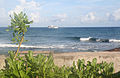 View from Amboyna Cay
 -
 Vietnamese guards on Amboyna Cay


Recent history
From 1956 on, in the face of Chinese and Philippine opposition, the Republic of Vietnam Navy began to launch various operations to reassert control over the Spratly Islands. Crewmembers erected sovereignty steles on almost all of them and built poles to hoist the Vietnamese flag. The cruiser Tuy Dong (HQ-04) was assigned these missions in August 1956.[4]
On 20 May 1963, the Republic of Vietnam Navy landed on Amboyna Cay and rebuilt the sovereignty stele.[5]
On 28 April 1975, the Vietnam People's Navy landed on Amboyna Cay but later left the cay due to harsh climate.
In 1978 the Royal Malaysian Navy landed on the island and placed markers. However, the markers were subsequently destroyed by Vietnam People's Navy who has returned and occupied the cay since 10 March 1978.[6]
On 31 March 1979, forces occupying the cay fired warning shots at a boat transporting six amateur radio operators ("hams") attempting a DX-pedition to Amboyna Cay.[7]
In 1982, a Singapore yacht operated by the owner and his wife transporting four German hams on a DX-pedition to Amboyna Cay was fired upon by Vietnamese forces. One of the hams, Diethelm Mueller, was hit by an artillery round and fell overboard. The yacht burned and the rest of the party drifted for 11 days on debris. Another ham, Gero Band, died of thirst the day before the survivors were rescued by a passing Japanese freighter which took them to Hong Kong.[8][9]
See also
References
- ^ "Vietnam Builds Up its Remote Outposts - Amboyna Cay". Center for Strategic and International Studies. Retrieved 1 November 2020.
- ^ NGA Chart 93047 showing the South West of Dangerous Ground, www.oceangrafix.com
- ^ "Digital Gazetter of Spratly Islands". Archived from the original on 21 March 2008. Retrieved 2008-03-22.
- ^ ""White Paper on the Hoang Sa (Paracel) and Truong Sa (Spratly) Islands (1975)". Ministry of Foreign Affairs (Republic of Vietnam).
- ^ ""White Paper on the Hoang Sa (Paracel) and Truong Sa (Spratly) Islands (1975)". Ministry of Foreign Affairs (Republic of Vietnam).
- ^ Joshua Ho; Sam Bateman (15 February 2013). Maritime Challenges and Priorities in Asia: Implications for Regional Security. Routledge. pp. 74–. ISBN 978-1-136-29820-2.
- ^ "Log of the Banyandah – South China Sea, March 31, 1979". Jack and Jude. Retrieved 2024-04-06.
- ^ "The Spratly Islands DXpedition Gets Wings". arrl.org. November 30, 2010.
- ^ Drobnica, Baldur (January 1989). "Disaster at Spratly: The 1983 German DXPedition" (PDF). The DX Magazine. Vol. I, no. 1. Retrieved 14 May 2023.
External links
- Maritime Transparency Initiative Island Tracker
- v
- t
- e
- Dangerous Ground
- Loaita Bank
- London Reefs
- North Danger Reef
- Reed Tablemount
- Tizard Bank
- Union Banks


