Altocumulus volutus
| Altocumulus volutus | |
|---|---|
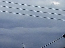 Distant altocumulus volutus cloud | |
| Abbreviation | Ac vol |
| Genus | Altocumulus |
| Species | Volutus |
| Altitude | 2,000-7,000 m (7,000-23,000 ft) |
| Appearance | small, single, horizontal, rolling mid-level altocumulus line |
| Precipitation | None |
Altocumulus volutus is a type of altocumulus cloud. This cloud type has the appearance of a single, small, horizontal, rolling line, it is relatively rare compared with its counterpart stratocumulus volutus,[1] This cloud does not attach to any other cloud. It may or may not appear with altocumulus clouds of different species. When found in a thunderstorm, it forms when cold air from a thunderstorm's downdraft makes the already present warm and moist air rise, expanding and cooling as it rises. It then condenses, although the most likely scenario is that it condenses into a shelf cloud or roll cloud, rather than an altocumulus volutus cloud.[2] When found in environments where it is not associated with a thunderstorm, it forms because of wind shear (difference of wind speed and direction between the mid-levels of the atmosphere and the surface).[3]
References
- v
- t
- e
Cloud genera and selected species, supplementary features, and other airborne hydrometeors - WMO Latin terminology except where indicated
| Extreme-level 80–85 km |
|
|---|
| Very high-level 15–30 km |
|
|---|
| High-level 3–18 km |
| ||||||||||||||||||||||||||||
|---|---|---|---|---|---|---|---|---|---|---|---|---|---|---|---|---|---|---|---|---|---|---|---|---|---|---|---|---|---|
| Medium-level 2–8 km |
| ||||||||||||||||||||||||||||
| Low-level 0–2 km |
| ||||||||||||||||||||||||||||
| Non-height specific |
|
 | This article related to a specific weather event is a stub. You can help Wikipedia by expanding it. |
- v
- t
- e


