1948 Lady Caycay earthquake
Earthquake in the Philippines
- MMI X (Extreme)
- PEIS IX (Devastating)
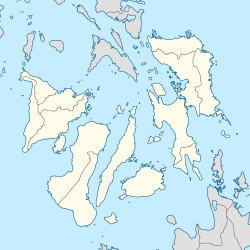
The 1948 Lady Caycay earthquake occurred at 01:46 PST (UTC+08:00) on 25 January 1948 with an estimated moment magnitude of 7.8 and a maximum Mercalli intensity of X (Extreme). The epicenter was between the municipalities of Anini-y, Antique, and Dao (present-day Tobias Fornier in Antique) on Panay Island, Philippines.
The earthquake was the second biggest on record in the country as it caused widespread damage in Panay and nearby islands. However, accounts of its intensity and the tsunamis it generated are sparse, possibly because the earthquake struck as the Philippines was recovering from the effects of the Second World War.[3]
Etymology
Caycay is a Kinaray-a and Hiligaynon term describing the scratches on the ground similar to those made by chickens. The effects of the earthquake, which chiefly manifested as fissures on the ground, were said to be similar to chicken scratches.[3] Much of Iloilo province lies on soft ground, which is one of the possible reasons for the numerous fissures that appeared, especially in low-lying parts of the province.
Effect

José María Cuenco, the Bishop of Jaro, estimated that the damage to 15 churches destroyed on Panay alone amounted to ₱7,000,000.
Antique province
In the town of Anini-y (the earthquake's epicentre), no distinct damage was seen in the century-old church—the only confirmed masonry structure existing at the time.[3] The church, which was originally built in 1830 had been damaged during the Second World War. In Pandan and Culasi towns, it was reported that 50% of the houses were destroyed. Massive landslides also occurred in the mountain area.[3]
Aklan province
Ibajay Bridge and Kalibo Bridge, which were the two of the biggest bridges in Panay, sustained damage.[3]
Capiz province
The Immaculate Conception Metropolitan Cathedral in Capiz (now Roxas City) was reported to have been damaged by the earthquake.[3]
Iloilo province
Most of the significant damage was found in the Iloilo province, specifically to extant Spanish-era churches. Bridges, communication lines, as well as public and private buildings all sustained heavy damage.
The churches in Igbaras, San Miguel, Oton, and Maasin were severely damaged and were demolished.[3] The belfries of churches in Alimodian, Duenas, Dumangas, Guimbal, Lambunao, Passi, San Joaquin, and Arevalo districts in Iloilo City collapsed, while Jaro Cathedral (the city's episcopal see) was also severely damaged. Twenty-one were reportedly killed in the city, and another forty-three were injured. Damage to churches was estimated at ₱200,000, with the total damage to the city reaching ₱1,000,000.[3] The Coronet Tower in Arevalo District also collapsed, as did the old Central School and back portion of the church in León. The churches of Pavia, Tubungan, Miag-ao, and Tigbauan also sustained damage.[3]
Fissures
Fissures erupted in the streets, causing traffic disruptions. Fissures were also observed along the roads between Pototan and Dingle and along the Santa Barbara railway. Fissures were also noted in the streets of Oton[3](Bautista, M.L.P, et al., 2011).
Ground disruptions described as “little canyons”, possibly the sand blows, were observed in Pototan, Cabatuan, Dingle, Passi, and Calinog. A new, small brook appeared after huge cracks appeared at Tiring Landing Field (now the site of the Iloilo International Airport) in Cabatuan. In the city's Fort San Pedro, large fissures 4 metres wide by 10 metres long opened such that seawater was already visible.[3]
Tsunami
Local accounts have pointed to a 2-metre high wave that was seen after the earthquake. Fish corals from the Iloilo shore towns of Oton to San Joaquin were destroyed by the tsunami. Damage was estimated to be at ₱250,000. The fish corals were detached from the log moorings. The waves did not move inward thereby sparing more damage to life and property.[3]
See also
References
- ^ a b c "M 7.8 – Panay, Philippines". United States Geological Survey. January 24, 1948. Retrieved August 27, 2017.
- ^ "PRESS RELEASE: "Join the earthquake drill" urges DOST-PHIVOLCS". phivolcs.dost.gov.ph. PHIVOLCS. Retrieved February 21, 2019.
- ^ a b c d e f g h i j k l Bautista M.L.P.; Bautista B.C.; Narag I.C.; Atando R.A. & Relota E.P. (April 2011). "The 1984 (Ms 8.2) Lady Caycay Earthquake and Tsunami and Its Possible Socio-economic Impact to Western Visayan Communities in the Philippines". Proceedings of the Ninth Pacific Conference on Earthquake Engineering Auckland, New Zealand.
- ^ "M 6.7 - Panay, Philippines". United States Geological Survey. Retrieved March 12, 2018.
- ^ "M 6.5 - Negeros, Philippines". United States Geological Survey. Retrieved March 12, 2018.
External links
- The International Seismological Centre has a bibliography and/or authoritative data for this event.
- v
- t
- e
Earthquakes in the 1940s
- El Centro (6.9, May 18)
- Lima (8.2, May 24)†
- Shakotan (7.5, Aug 1)
- Vrancea (7.7, Nov 10) †‡
- New Hampshire (5.3 & 5.6, Dec 20 & Dec 24)
- Sa'dah (5.8, Jan 11) †‡
- Colima (7.7, Apr 15) †
- Andaman Islands (7.7–8.1, June 26)
- Van–Erciş (5.9, Sept 10) †
- Hyūga-nada (8.0, Nov 18)
- Gloria Fault (8.0, Nov 25)
- Chungpu (7.1, Dec 17) †
- Ecuador (7.9, May 14) †
- Wairarapa, New Zealand (7.2, June 24) †
- Guatemala (7.7, Aug 6) †
- Peru (8.2, Aug 24) †
- Niksar–Erbaa, Turkey (7.0, Dec 20) †‡
- Ovalle (7.9–8.3, April 6)
- Alahan Panjang (7.2 & 7.5, June 8 & 9)
- Adapazarı–Hendek (6.6, June 20) †
- Central Java (7.0, July 23) †
- Tottori (7.0, Sept 10) †
- Tosya–Ladik (7.5, Nov 26) ‡†
- San Juan (6.7–.7.8, Jan 15) †‡
- Bolu–Gerede (7.5, Feb 1) †
- Cornwall–Massena (5.8, Sept 5)
- Gulf of Edremit–Ayvacik (6.7, Oct 6) †
- Tōnankai (8.1, Dec 5) †
- Valais (6.1, January 25)
- Aleutian Islands (8.6, April 1) †
- Varto–Hınıs (5.9, May 31) †
- Vancouver Island (7.3, June 23)
- Dominican Republic (8.1, Aug 4) ‡†
- Sagaing (8.0, 7.8, Sep 12)
- Kyrgyzstan (7.6, Nov 2)
- Peru (6.8, Nov 10) †
- Hsinhua (6.1, Dec 5) †
- Nankai (8.1, Dec 21) †
- Lady Caycay (8.2, Jan 25) †
- Litang (7.2, May 25) †
- Fukui (6.8, June 28) †
- Salta (7.0, Aug 25)
- Ashgabat (7.3, Oct 5) ‡†
- Desert Hot Springs (6.3, Dec 4)
- Olympia (6.7, April 13)
- Khait (7.4, July 10) ‡†
- Ambato (6.8, Aug 5) †
- Karlıova (6.7, Aug 17) †
- Queen Charlotte Islands (8.1, Aug 22)
- Tierra del Fuego (7.8, Dec 17)
† indicates earthquake resulting in at least 30 deaths
‡ indicates the deadliest earthquake of the year
‡ indicates the deadliest earthquake of the year


