1792 Unzen landslide and tsunami
Natural disaster in Japan
32°48′N 130°18′E / 32.8°N 130.3°E / 32.8; 130.3The 1792 Unzen landslide and tsunami resulted from the volcanic activities of Mount Unzen (in the Shimabara Peninsula of Nagasaki Prefecture, Japan) on 21 May. This caused the collapse of the southern flank of the Mayuyama dome in front of Mount Unzen, resulting in a tremendous tsunami, killing 15,000 people altogether.[2] It was also called Shimabara erupted, Higo affected (島原大変肥後迷惑), (Shimabara means the central mountain of the Shimabara Peninsula) since many people were killed by this tsunami in Higo (Kumamoto Prefecture, situated 20 km (12.4 mi) across the Ariake Sea).
Volcanic activities
Towards the end of 1791, a series of earthquakes occurred on the western flank of Mount Unzen which gradually moved towards Fugen-dake (one of Mount Unzen's peaks). In February 1792, Fugen-dake started to erupt, triggering a lava flow which continued for two months. Meanwhile, the earthquakes continued, shifting nearer to the city of Shimabara. On the night of 21 May, two large earthquakes were followed by a collapse of the eastern flank of Mount Unzen's Mayuyama dome, causing a landslide which swept through the city of Shimabara and into the Ariake Sea, triggering a great tsunami.
-
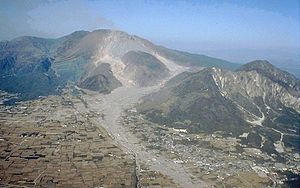 Mount Unzen (center) and Mayuyama (right) showing the destruction, recent photo
 -
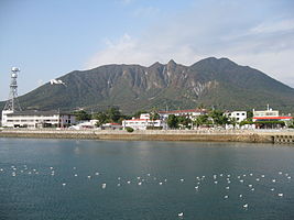 Mayuyama of Shimabara Peninsula, from the sea of Shimabara City


Megatsunami
It is not known whether the collapse occurred as a result of an eruption of the dome or as a result of the earthquakes. The tsunami struck Higo Province on the other side of Ariake Bay before bouncing back and hitting Shimabara again. Out of an estimated total of 15,000 fatalities, around 5,000 are thought to have been killed by the landslide, around 5,000 by the tsunami across the bay in Higo Province, and a further 5,000 by the tsunami returning to strike Shimabara. The initial wave once reached a height of 330 ft (100 m), classing this tsunami as a megatsunami. At the Osaki-bana point Futsu town, the waves locally grew to a height of 187 ft (57 m) due to the effect of sea bottom topography.
Monuments
As of July, 1991, the following monuments have been found:[3]
| Kind of Monument | Kumamoto Prefecture | Nagasaki Prefecture | Total |
|---|---|---|---|
| Memorial monument | 43 | 41 | 84 |
| Tsunami border monument | 5 | 0 | 5 |
| Graves | 16 | 90 | 106 |
| Simple monument | 1 | 0 | 1 |
| Others | 9 | 3 | 12 |
| Total | 74 | 134 | 208 |
Lake Shirachi

Lake Shirachi is a pond in Shimabara city, Nagasaki Prefecture which was created after the landslide at Mayuyama created by the inpouring of underground water. Its size was first 1 km (south-north) and 300m 400m (east to west), but the production of a water exit river made it smaller and it is now 200 m by 70 m.
Tsukumojima (99 Islets)
As a result of the destruction, Tsukumojima or 99 islets or rocks were distributed near Shimabara city. In the same Nagasaki Prefecture, there are 99 islands or Kujūkushima distributed from Sasebo city to Hirado city. These islands are different from Tsukumojima.
See also
 Earth sciences portal
- 1741 eruption of Oshima–Ōshima and the Kampo tsunami
- 1771 Great Yaeyama Tsunami
- List of earthquakes in Japan
- List of historical earthquakes
- 1888 Ritter Island eruption and tsunami
References
- ^ National Geophysical Data Center. "Comments for the Significant Earthquake". Retrieved 22 July 2011.
- ^ Johnston, Eric (1 March 2011). "Latest volcano show: Shinmoe". Japan Times. p. 3. Retrieved 5 May 2014.
- ^ 200 Years after the Kansei Great Tsunami, Symposium and Exhibition of Unzen Disaster Booklet published by Newspaper Museum, Yoyasu Machi, Kumamoto-shi, 1991
- v
- t
- e
- 684 Hakuho
- 869 Jōgan
- 1293 Kamakura
- 1361 Shōhei
- 1498 Meiō
- 1586 Tenshō
- 1596 Fushimi
- 1605 Keichō
- 1611 Aizu
- 1611 Sanriku
- 1662 Kanbun
- 1662 Hyūga-nada
- 1677 Bōsō
- 1703 Genroku
- 1707 Hōei
- 1741 Kampo
- 1751 Takada
- 1771 Great Yaeyama
- 1792 Unzen
- 1804 Kisakata
- 1828 Sanjō
- 1833 Shōnai
- 1847 Zenkoji
- 1854 Iga–Ueno
- 1854 Nankai
- 1854 Tōkai
- 1855 Edo
- 1858 Hietsu
- 1872 Hamada
- 1889 Kumamoto
- 1891 Mino–Owari
- 1894 Tokyo
- 1894 Shōnai
- 1896 Sanriku
- 1896 Rikuu
- 1911 Kikai Island
- 1914 Senboku
- 1922 Shimabara
- 1923 Great Kantō
- 1925 North Tajima
- 1927 North Tango
- 1930 North Izu
- 1933 Sanriku
- 1936 Miyagi
- 1939 Oga
- 1940 Shakotan
- 1941 Hyūga-nada
- 1943 Tottori
- 1944 Tōnankai
- 1945 Mikawa
- 1946 Nankai
- 1948 Fukui
- 1952 Tokachi
- 1961 North Mino
- 1963 Kuril Islands
- 1964 Niigata
- 1968 Ebino
- 1968 Hyūga-nada
- 1968 Tokachi
- 1973 Nemuro Peninsula
- 1974 Izu Peninsula
- 1978 Izu Ōshima
- 1978 Miyagi
- 1982 Urakawa
- 1983 Sea of Japan
- 1984 Nagano
- 1993 Kushiro
- 1993 Okushiri
- 1994 offshore Sanriku
- 1995 Hanshin
- 2000 Izu Islands
- 2000 Tottori
- 2001 Geiyo
- 2003 Miyagi
- 2003 Tokachi
- 2004 Chūetsu
- 2005 Fukuoka
- 2005 Miyagi
- 2006 Kuril Islands
- 2007 Chūetsu
- 2007 Kuril Islands
- 2007 Noto
- 2008 Iwate–Miyagi
- 2008 Iwate
- 2009 Shizuoka
- 2011 Tōhoku
- 2011 Nagano
- 2011 Shizuoka
- 2011 Miyagi
- 2011 Fukushima
- 2012 Chiba
- 2012 Sanriku
- 2014 Nagano
- 2015 Ogasawara
- 2016 Kumamoto
- 2016 Tottori
- 2016 Fukushima
- 2018 Osaka
- 2018 Hokkaido Eastern Iburi
- 2019 Yamagata
- 2021 Fukushima
- 2021 Miyagi
- 2021 Chiba
- 2022 Fukushima
- 2023 Noto
- 2024 Noto


